Sagebrush Valley E. Topo Map New Mexico
To zoom in, hover over the map of Sagebrush Valley E.
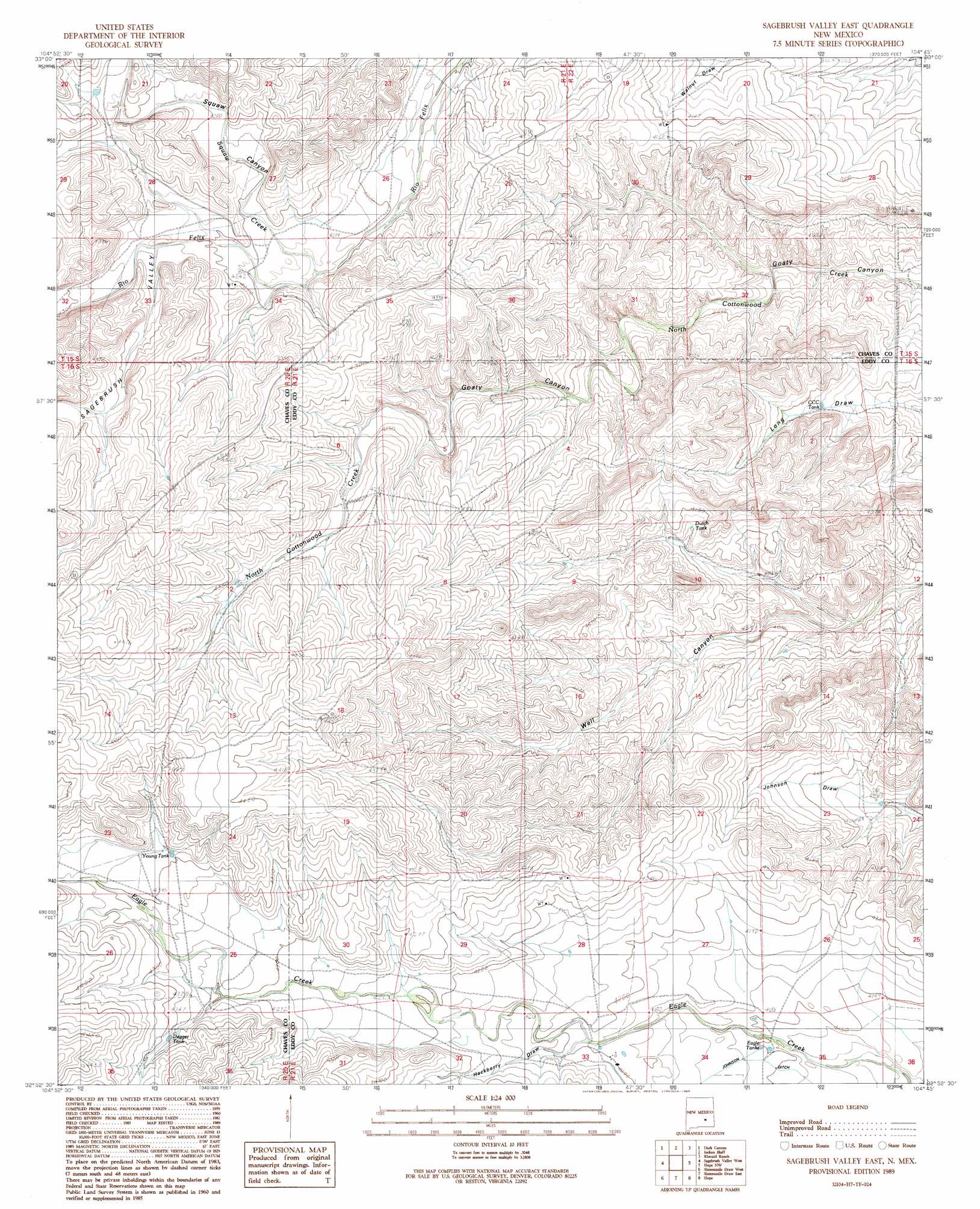
USGS Topo Quad 32104h7 - 1:24,000 scale
| Topo Map Name: | Sagebrush Valley E. |
| USGS Topo Quad ID: | 32104h7 |
| Print Size: | ca. 21 1/4" wide x 27" high |
| Southeast Coordinates: | 32.875° N latitude / 104.75° W longitude |
| Map Center Coordinates: | 32.9375° N latitude / 104.8125° W longitude |
| U.S. State: | NM |
| Filename: | o32104h7.jpg |
| Download Map JPG Image: | Sagebrush Valley E. topo map 1:24,000 scale |
| Map Type: | Topographic |
| Topo Series: | 7.5´ |
| Map Scale: | 1:24,000 |
| Source of Map Images: | United States Geological Survey (USGS) |
| Alternate Map Versions: |
Sagebrush Valley East NM 1989, updated 1989 Download PDF Buy paper map Sagebrush Valley East NM 2010 Download PDF Buy paper map Sagebrush Valley East NM 2013 Download PDF Buy paper map Sagebrush Valley East NM 2017 Download PDF Buy paper map |
1:24,000 Topo Quads surrounding Sagebrush Valley E.
Flying H Ne |
Skunk Canyon |
Lucky Lake |
Juan Lake |
Peters Lake |
Flying H |
Dark Canyon |
Indian Bluff |
Kincaid Ranch |
Hackberry Ranch |
Singer Lake |
Sagebrush Valley W. |
Sagebrush Valley E. |
Hope Nw |
Hope Ne |
Meadow Hill |
Sixteenmile Draw West |
Sixteenmile Draw East |
Hope |
Hope Se |
Lewis Peak Ne |
Encino Draw |
Holt Tank |
Antelope Sink |
Parish Ranch |
> Back to 32104e1 at 1:100,000 scale
> Back to 32104a1 at 1:250,000 scale
> Back to U.S. Topo Maps home
Sagebrush Valley E. topo map: Gazetteer
Sagebrush Valley E.: Canals
Johnson Ditch elevation 1265m 4150′Sagebrush Valley E.: Reservoirs
CCC Tank elevation 1244m 4081′Dagger Tank elevation 1321m 4333′
Dutch Tank elevation 1258m 4127′
Eagle Tanks elevation 1266m 4153′
Young Tank elevation 1334m 4376′
Sagebrush Valley E.: Streams
Squaw Creek elevation 1284m 4212′Sagebrush Valley E.: Valleys
Goaty Canyon elevation 1275m 4183′Hackberry Draw elevation 1278m 4192′
Sagebrush Valley elevation 1303m 4274′
Squaw Canyon elevation 1293m 4242′
Sagebrush Valley E. digital topo map on disk
Buy this Sagebrush Valley E. topo map showing relief, roads, GPS coordinates and other geographical features, as a high-resolution digital map file on DVD: