Tanner Ranch Topo Map New Mexico
To zoom in, hover over the map of Tanner Ranch
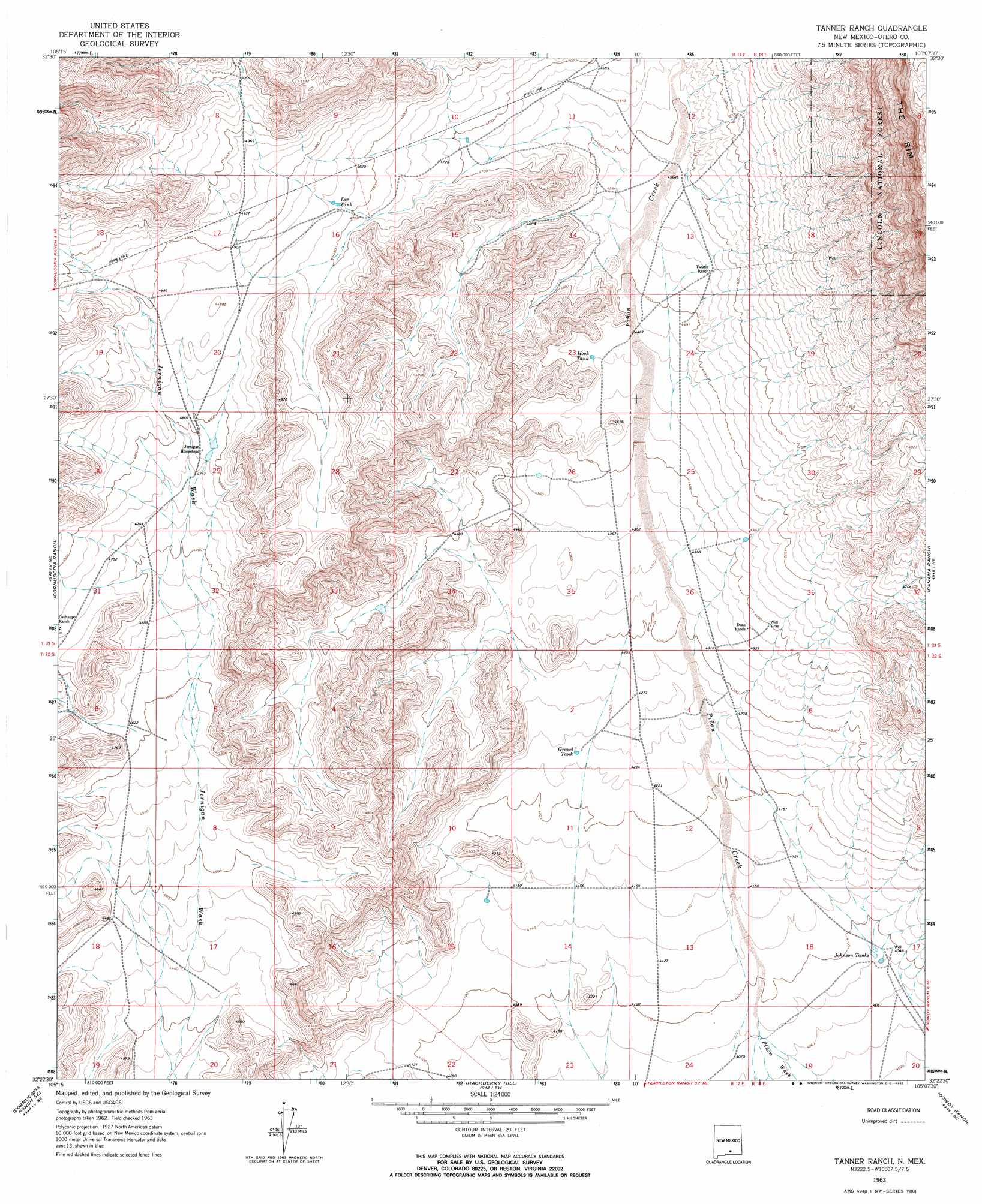
USGS Topo Quad 32105d2 - 1:24,000 scale
| Topo Map Name: | Tanner Ranch |
| USGS Topo Quad ID: | 32105d2 |
| Print Size: | ca. 21 1/4" wide x 27" high |
| Southeast Coordinates: | 32.375° N latitude / 105.125° W longitude |
| Map Center Coordinates: | 32.4375° N latitude / 105.1875° W longitude |
| U.S. State: | NM |
| Filename: | o32105d2.jpg |
| Download Map JPG Image: | Tanner Ranch topo map 1:24,000 scale |
| Map Type: | Topographic |
| Topo Series: | 7.5´ |
| Map Scale: | 1:24,000 |
| Source of Map Images: | United States Geological Survey (USGS) |
| Alternate Map Versions: |
Tanner Ranch NM 1963, updated 1965 Download PDF Buy paper map Tanner Ranch NM 1963, updated 1965 Download PDF Buy paper map Tanner Ranch NM 2001, updated 2003 Download PDF Buy paper map Tanner Ranch NM 2011 Download PDF Buy paper map Tanner Ranch NM 2013 Download PDF Buy paper map Tanner Ranch NM 2017 Download PDF Buy paper map |
| FStopo: | US Forest Service topo Tanner Ranch is available: Download FStopo PDF Download FStopo TIF |
1:24,000 Topo Quads surrounding Tanner Ranch
Avis |
Chimney Lake |
Lewis Peak |
Lewis Peak Ne |
Encino Draw |
Pinon |
Cornucopia Canyon |
Pinon Ranch |
Bullis Spring Ranch |
South Taylor Tank |
Indian Draw |
Cornucopia Ranch |
Tanner Ranch |
Panama Ranch |
Packsaddle Canyon |
Cleones Tank |
Cornucopia Ranch Se |
Hackberry Hill |
Gowdy Ranch |
Algerita Canyon |
Shiloh Hills |
Van Winkle Lake |
Lewis Canyon |
Sheep Draw |
La Paloma Canyon |
> Back to 32105a1 at 1:100,000 scale
> Back to 32104a1 at 1:250,000 scale
> Back to U.S. Topo Maps home
Tanner Ranch topo map: Gazetteer
Tanner Ranch: Reservoirs
Dee Tank elevation 1471m 4826′Gravel Tank elevation 1290m 4232′
Hook Tank elevation 1360m 4461′
Johnson Tanks elevation 1246m 4087′
Tanner Ranch: Streams
Piñon Creek elevation 1245m 4084′Tanner Ranch digital topo map on disk
Buy this Tanner Ranch topo map showing relief, roads, GPS coordinates and other geographical features, as a high-resolution digital map file on DVD: