Rogers Ruins Topo Map New Mexico
To zoom in, hover over the map of Rogers Ruins
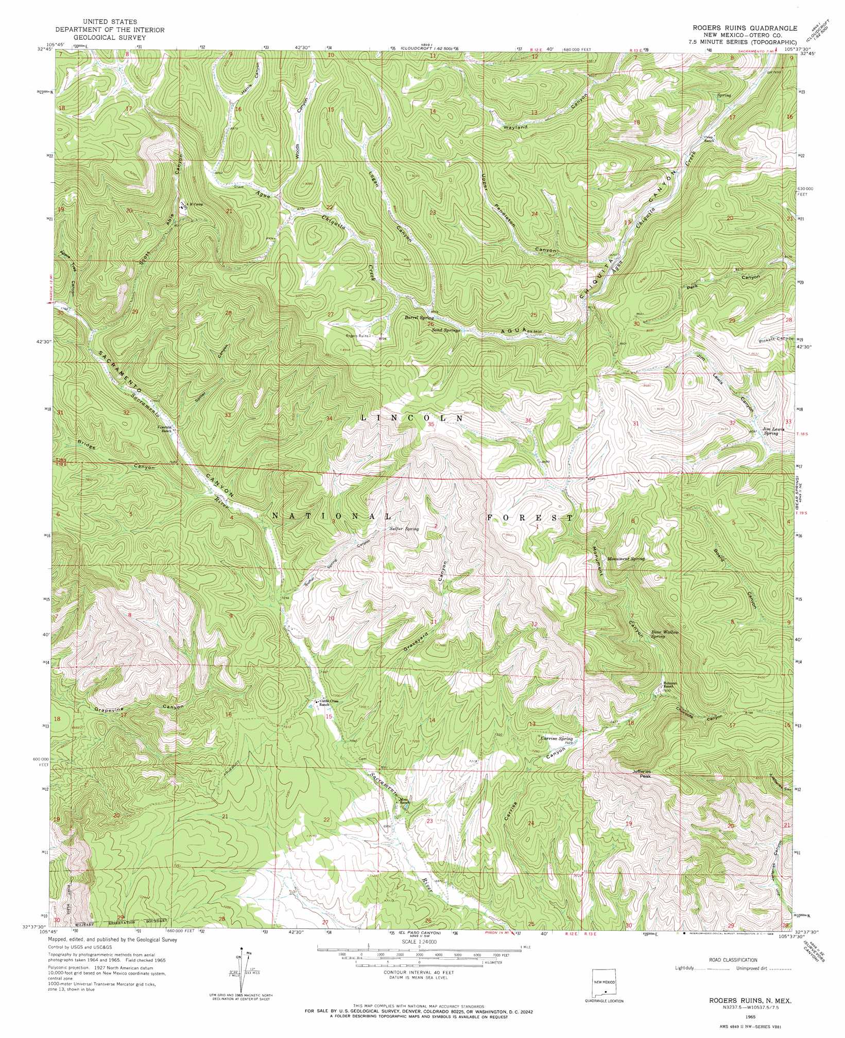
USGS Topo Quad 32105f6 - 1:24,000 scale
| Topo Map Name: | Rogers Ruins |
| USGS Topo Quad ID: | 32105f6 |
| Print Size: | ca. 21 1/4" wide x 27" high |
| Southeast Coordinates: | 32.625° N latitude / 105.625° W longitude |
| Map Center Coordinates: | 32.6875° N latitude / 105.6875° W longitude |
| U.S. State: | NM |
| Filename: | o32105f6.jpg |
| Download Map JPG Image: | Rogers Ruins topo map 1:24,000 scale |
| Map Type: | Topographic |
| Topo Series: | 7.5´ |
| Map Scale: | 1:24,000 |
| Source of Map Images: | United States Geological Survey (USGS) |
| Alternate Map Versions: |
Rogers Ruins NM 1965, updated 1968 Download PDF Buy paper map Graveyard Canyon NM 2004, updated 2006 Download PDF Buy paper map Graveyard Canyon NM 2011 Download PDF Buy paper map Graveyard Canyon NM 2013 Download PDF Buy paper map Graveyard Canyon NM 2017 Download PDF Buy paper map |
| FStopo: | US Forest Service topo Graveyard Canyon is available: Download FStopo PDF Download FStopo TIF |
1:24,000 Topo Quads surrounding Rogers Ruins
Alamogordo North |
High Rolls |
Cloudcroft |
Harvey Ranch |
Mayhill |
Alamogordo South |
Sacramento Peak |
Bluff Springs |
Sacramento |
Woodson Canyon |
Deadman Canyon |
Bug Scuffle Canyon |
Rogers Ruins |
Bear Spring |
Avis |
Pipeline Canyon |
Culp Canyon |
El Paso Canyon |
Surveyors Canyon |
Pinon |
Wilde Tank |
Otero Mesa North |
El Paso Draw |
Sixteen Canyon |
Indian Draw |
> Back to 32105e1 at 1:100,000 scale
> Back to 32104a1 at 1:250,000 scale
> Back to U.S. Topo Maps home
Rogers Ruins topo map: Gazetteer
Rogers Ruins: Airports
Timberon Airport elevation 2201m 7221′Rogers Ruins: Populated Places
Crisp elevation 2449m 8034′Rogers Ruins: Reservoirs
Board Tank elevation 2498m 8195′Logan Tank elevation 2742m 8996′
Rogers Tank elevation 2658m 8720′
Wood Tank elevation 2737m 8979′
Rogers Ruins: Springs
Barrel Spring elevation 2611m 8566′Bear Wallow Spring elevation 2385m 7824′
Carrisa Spring elevation 2239m 7345′
Jim Lewis Spring elevation 2467m 8093′
Monument Spring elevation 2496m 8188′
Sand Springs elevation 2599m 8526′
Sulfur Spring elevation 2337m 7667′
Rogers Ruins: Summits
Jefferies Peak elevation 2591m 8500′Rogers Ruins: Valleys
Apple Tree Canyon elevation 2365m 7759′Bridge Canyon elevation 2264m 7427′
Chilcoote Canyon elevation 2305m 7562′
Graveyard Canyon elevation 2156m 7073′
Harris Canyon elevation 2742m 8996′
Logan Canyon elevation 2616m 8582′
Monument Canyon elevation 2305m 7562′
Sacramento Canyon elevation 2203m 7227′
Scott Able Canyon elevation 2341m 7680′
Spiller Canyon elevation 2302m 7552′
Sulfur Spring Canyon elevation 2208m 7244′
Upper Pendleton Canyon elevation 2513m 8244′
Woods Canyon elevation 2682m 8799′
Rogers Ruins digital topo map on disk
Buy this Rogers Ruins topo map showing relief, roads, GPS coordinates and other geographical features, as a high-resolution digital map file on DVD: