Bug Scuffle Canyon Topo Map New Mexico
To zoom in, hover over the map of Bug Scuffle Canyon
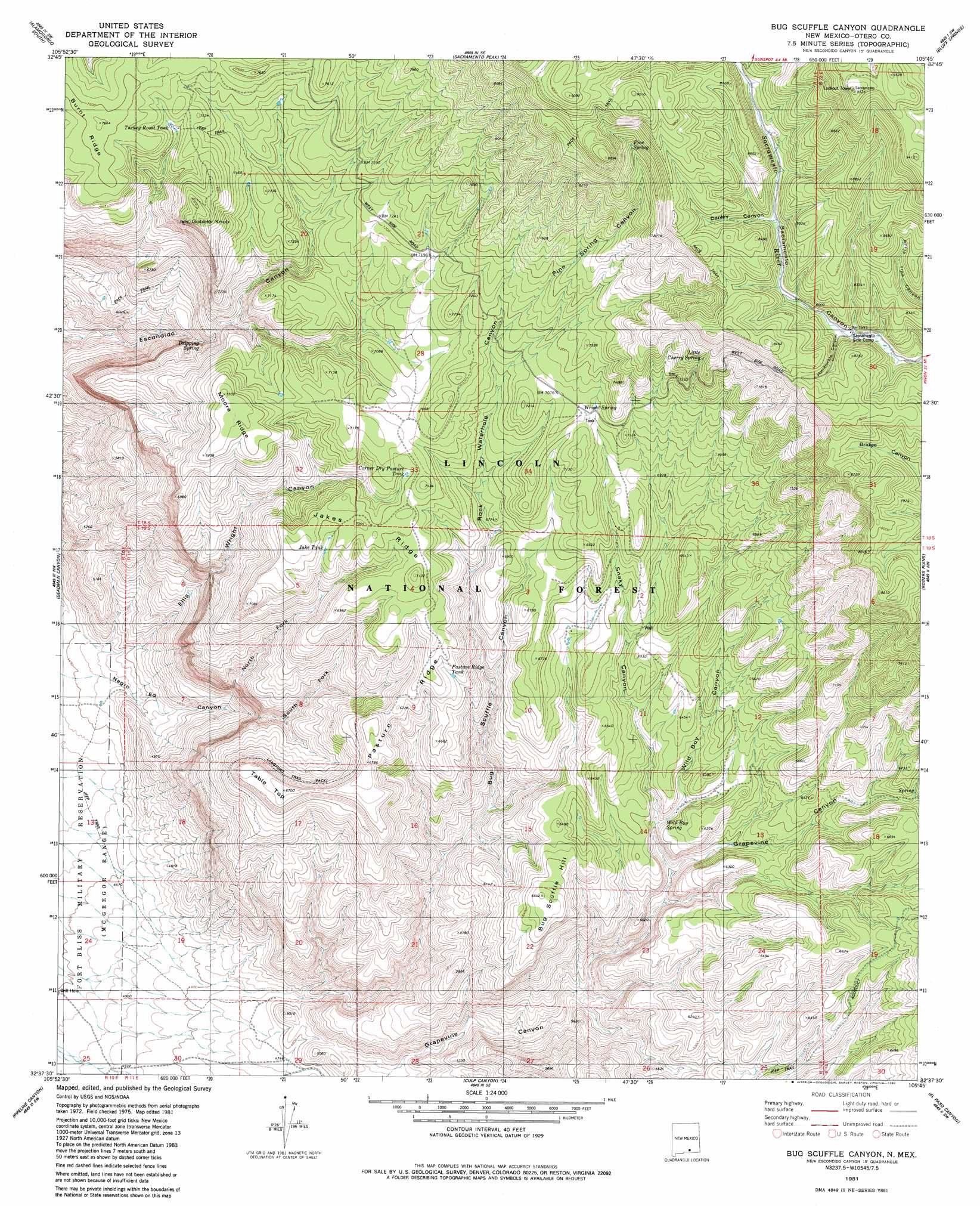
USGS Topo Quad 32105f7 - 1:24,000 scale
| Topo Map Name: | Bug Scuffle Canyon |
| USGS Topo Quad ID: | 32105f7 |
| Print Size: | ca. 21 1/4" wide x 27" high |
| Southeast Coordinates: | 32.625° N latitude / 105.75° W longitude |
| Map Center Coordinates: | 32.6875° N latitude / 105.8125° W longitude |
| U.S. State: | NM |
| Filename: | o32105f7.jpg |
| Download Map JPG Image: | Bug Scuffle Canyon topo map 1:24,000 scale |
| Map Type: | Topographic |
| Topo Series: | 7.5´ |
| Map Scale: | 1:24,000 |
| Source of Map Images: | United States Geological Survey (USGS) |
| Alternate Map Versions: |
Bug Scuffle Canyon NM 1981, updated 1982 Download PDF Buy paper map Bug Scuffle Canyon NM 2004, updated 2006 Download PDF Buy paper map Bug Scuffle Canyon NM 2011 Download PDF Buy paper map Bug Scuffle Canyon NM 2013 Download PDF Buy paper map Bug Scuffle Canyon NM 2017 Download PDF Buy paper map |
| FStopo: | US Forest Service topo Bug Scuffle Canyon is available: Download FStopo PDF Download FStopo TIF |
1:24,000 Topo Quads surrounding Bug Scuffle Canyon
Malone Draw |
Alamogordo North |
High Rolls |
Cloudcroft |
Harvey Ranch |
Holloman |
Alamogordo South |
Sacramento Peak |
Bluff Springs |
Sacramento |
Tres Hermanos |
Deadman Canyon |
Bug Scuffle Canyon |
Rogers Ruins |
Bear Spring |
Tres Hermanos Se |
Pipeline Canyon |
Culp Canyon |
El Paso Canyon |
Surveyors Canyon |
Orogrande North |
Wilde Tank |
Otero Mesa North |
El Paso Draw |
Sixteen Canyon |
> Back to 32105e1 at 1:100,000 scale
> Back to 32104a1 at 1:250,000 scale
> Back to U.S. Topo Maps home
Bug Scuffle Canyon topo map: Gazetteer
Bug Scuffle Canyon: Reservoirs
Corner Dry Pasture Tank elevation 2129m 6984′Jake Tank elevation 2132m 6994′
Moore Tank elevation 2138m 7014′
Pasture Ridge Tank elevation 2039m 6689′
Turkey Roost Tank elevation 2257m 7404′
Bug Scuffle Canyon: Ridges
Burnt Ridge elevation 2320m 7611′Jakes Ridge elevation 2147m 7043′
Moore Ridge elevation 2212m 7257′
Pasture Ridge elevation 2049m 6722′
Bug Scuffle Canyon: Springs
Dripping Spring elevation 1861m 6105′Little Cherry Spring elevation 2354m 7723′
Pine Spring elevation 2673m 8769′
Wild Boy Spring elevation 1848m 6062′
Wright Spring elevation 2153m 7063′
Bug Scuffle Canyon: Summits
Bug Scuffle Hill elevation 1976m 6482′Gobbler Knob elevation 2376m 7795′
Table Top elevation 2045m 6709′
Bug Scuffle Canyon: Valleys
Bug Scuffle Canyon elevation 1425m 4675′Danley Canyon elevation 2476m 8123′
Ellis Wright Canyon elevation 1360m 4461′
Grapevine Canyon elevation 1451m 4760′
Hornbuckle Canyon elevation 2412m 7913′
McCracken Canyon elevation 1741m 5711′
North Fork Negro Ed Canyon elevation 1507m 4944′
Pine Spring Canyon elevation 2160m 7086′
Rock Waterhole Canyon elevation 1896m 6220′
Snaky Canyon elevation 1797m 5895′
South Fork Negro Ed Canyon elevation 1770m 5807′
Wild Boy Canyon elevation 1841m 6040′
Bug Scuffle Canyon digital topo map on disk
Buy this Bug Scuffle Canyon topo map showing relief, roads, GPS coordinates and other geographical features, as a high-resolution digital map file on DVD: