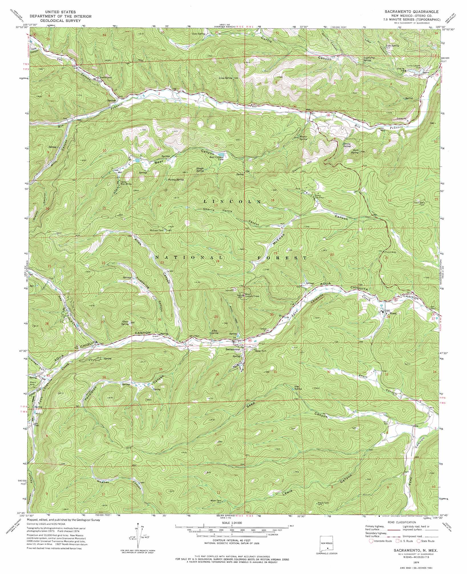
Sacramento Topo Map New Mexico
To zoom in, hover over the map of Sacramento
USGS Topo Quad 32105g5 - 1:24,000 scale
| Topo Map Name: | Sacramento |
| USGS Topo Quad ID: | 32105g5 |
| Print Size: | ca. 21 1/4" wide x 27" high |
| Southeast Coordinates: | 32.75° N latitude / 105.5° W longitude |
| Map Center Coordinates: | 32.8125° N latitude / 105.5625° W longitude |
| U.S. State: | NM |
| Filename: | o32105g5.jpg |
| Download Map JPG Image: | Sacramento topo map 1:24,000 scale |
| Map Type: | Topographic |
| Topo Series: | 7.5´ |
| Map Scale: | 1:24,000 |
| Source of Map Images: | United States Geological Survey (USGS) |
| Alternate Map Versions: |
Sacramento NM 1974, updated 1978 Download PDF Buy paper map Sacramento NM 2004, updated 2006 Download PDF Buy paper map Sacramento NM 2011 Download PDF Buy paper map Sacramento NM 2013 Download PDF Buy paper map Sacramento NM 2017 Download PDF Buy paper map |
| FStopo: | US Forest Service topo Sacramento is available: Download FStopo PDF Download FStopo TIF |
1:24,000 Topo Quads surrounding Sacramento
Domingo Peak |
Firman Canyon |
Elk-Silver |
Turkey Peak |
Clements Ranch |
High Rolls |
Cloudcroft |
Harvey Ranch |
Mayhill |
Elk |
Sacramento Peak |
Bluff Springs |
Sacramento |
Woodson Canyon |
Robertson Canyon |
Bug Scuffle Canyon |
Rogers Ruins |
Bear Spring |
Avis |
Chimney Lake |
Culp Canyon |
El Paso Canyon |
Surveyors Canyon |
Pinon |
Cornucopia Canyon |
> Back to 32105e1 at 1:100,000 scale
> Back to 32104a1 at 1:250,000 scale
> Back to U.S. Topo Maps home
Sacramento topo map: Gazetteer
Sacramento: Dams
Upper Rio Penasco Site One Dam elevation 2216m 7270′Upper Rio Penasco Site Two Dam elevation 2063m 6768′
Sacramento: Populated Places
Sacramento elevation 2221m 7286′Weed elevation 2148m 7047′
Sacramento: Post Offices
Weed Post Office elevation 2148m 7047′Sacramento: Reservoirs
Akers Trick Tank elevation 2265m 7431′Allen Tank elevation 2377m 7798′
Bear Canyon Lake elevation 2218m 7276′
Curtis Canyon Dam elevation 2073m 6801′
Ehart Tank elevation 2217m 7273′
Forks Tank elevation 2374m 7788′
Green Tank elevation 2393m 7851′
Lewis Tank elevation 2331m 7647′
McEwan Lake elevation 2499m 8198′
McEwan Trick Tank elevation 2501m 8205′
Middle Tank elevation 2413m 7916′
Prather Tank elevation 2201m 7221′
Robinson Tank elevation 2263m 7424′
Tower Tank elevation 2344m 7690′
Upper Allen Tank elevation 2407m 7896′
West Tank elevation 2414m 7919′
Sacramento: Springs
Allen Spring elevation 2275m 7463′Big Hill Spring elevation 2089m 6853′
Canyon Spring elevation 2159m 7083′
Denny Spring elevation 2164m 7099′
Goat Spring elevation 2282m 7486′
Green Spring elevation 2351m 7713′
Lake Spring elevation 2139m 7017′
Lightning Spring elevation 2121m 6958′
Lost Spring elevation 2206m 7237′
Lower Robinson Tank elevation 2221m 7286′
Red Hill Spring elevation 2093m 6866′
Robinson Spring elevation 2207m 7240′
Scott Spring elevation 2171m 7122′
Seep Spring elevation 2245m 7365′
Slough Spring elevation 2286m 7500′
Turkey Spring elevation 2308m 7572′
Weems Spring elevation 2117m 6945′
Sacramento: Streams
Bear Creek elevation 2089m 6853′Sacramento: Summits
Denny Hill elevation 2345m 7693′Sacramento: Valleys
Allen Canyon elevation 2242m 7355′Bear Canyon elevation 2113m 6932′
Charlie Harris Canyon elevation 2265m 7431′
Cienega Canyon elevation 2307m 7568′
Cox Canyon elevation 2170m 7119′
Cridebring Canyon elevation 2243m 7358′
Curtis Canyon elevation 2052m 6732′
Dark Canyon elevation 2252m 7388′
Dollins Canyon elevation 2134m 7001′
Ehart Canyon elevation 2098m 6883′
Greasy Canyon elevation 2256m 7401′
Hay Canyon elevation 2277m 7470′
Lake Canyon elevation 2081m 6827′
Lewis Canyon elevation 2135m 7004′
Little Lewis Canyon elevation 2151m 7057′
Mickison Canyon elevation 2212m 7257′
Pendleton Canyon elevation 2245m 7365′
Potato Canyon elevation 2315m 7595′
Seep Canyon elevation 2104m 6902′
Spring Canyon elevation 2308m 7572′
Wayland Canyon elevation 2337m 7667′
Wills Canyon elevation 2196m 7204′
Sacramento: Wells
10057 Water Well elevation 2132m 6994′Sacramento digital topo map on disk
Buy this Sacramento topo map showing relief, roads, GPS coordinates and other geographical features, as a high-resolution digital map file on DVD: