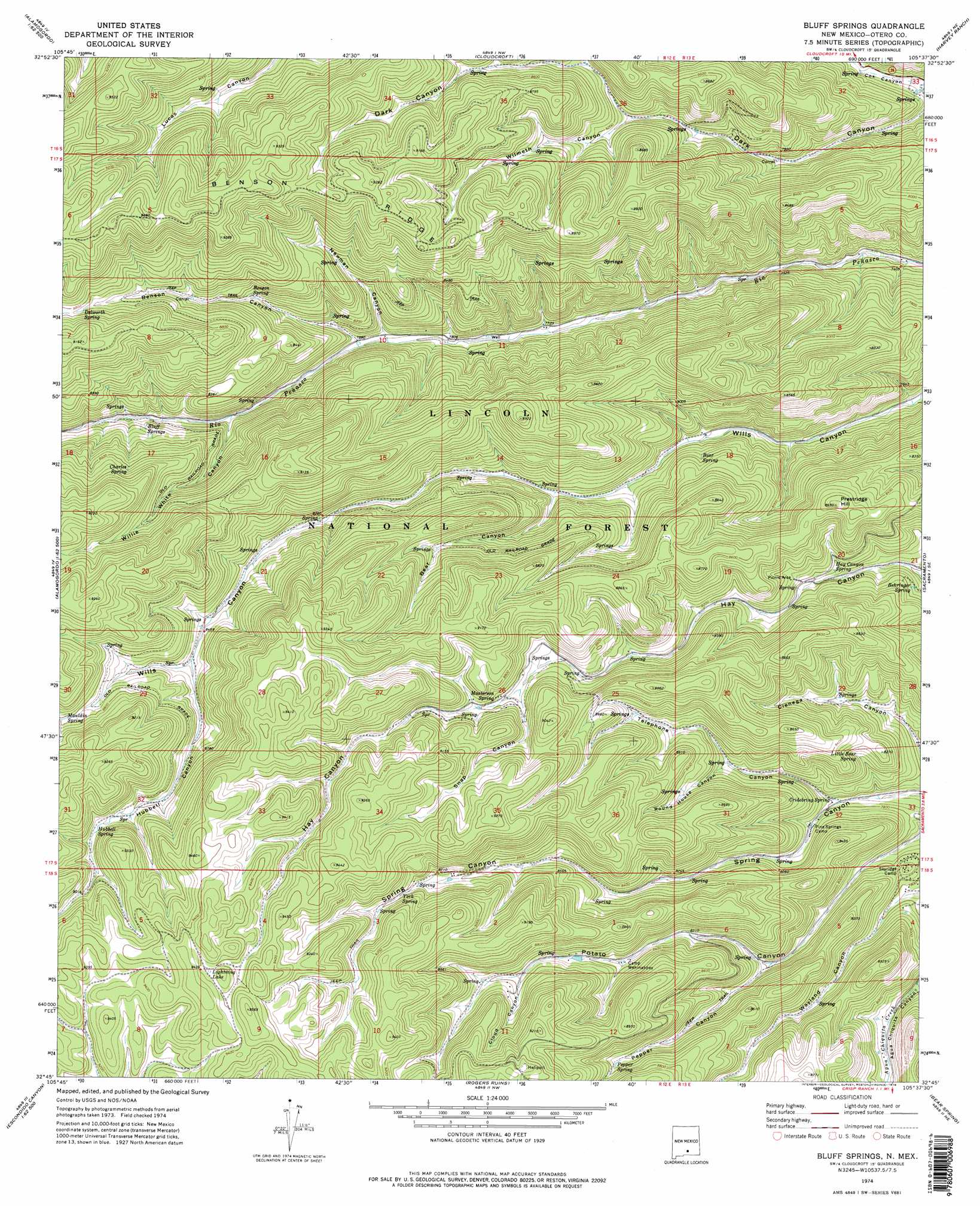
Bluff Springs Topo Map New Mexico
To zoom in, hover over the map of Bluff Springs
USGS Topo Quad 32105g6 - 1:24,000 scale
| Topo Map Name: | Bluff Springs |
| USGS Topo Quad ID: | 32105g6 |
| Print Size: | ca. 21 1/4" wide x 27" high |
| Southeast Coordinates: | 32.75° N latitude / 105.625° W longitude |
| Map Center Coordinates: | 32.8125° N latitude / 105.6875° W longitude |
| U.S. State: | NM |
| Filename: | o32105g6.jpg |
| Download Map JPG Image: | Bluff Springs topo map 1:24,000 scale |
| Map Type: | Topographic |
| Topo Series: | 7.5´ |
| Map Scale: | 1:24,000 |
| Source of Map Images: | United States Geological Survey (USGS) |
| Alternate Map Versions: |
Bluff Springs NM 1974, updated 1978 Download PDF Buy paper map Bluff Springs NM 2004, updated 2006 Download PDF Buy paper map Bluff Springs NM 2011 Download PDF Buy paper map Bluff Springs NM 2013 Download PDF Buy paper map Bluff Springs NM 2017 Download PDF Buy paper map |
| FStopo: | US Forest Service topo Bluff Springs is available: Download FStopo PDF Download FStopo TIF |
1:24,000 Topo Quads surrounding Bluff Springs
Sabinata Flat |
Domingo Peak |
Firman Canyon |
Elk-Silver |
Turkey Peak |
Alamogordo North |
High Rolls |
Cloudcroft |
Harvey Ranch |
Mayhill |
Alamogordo South |
Sacramento Peak |
Bluff Springs |
Sacramento |
Woodson Canyon |
Deadman Canyon |
Bug Scuffle Canyon |
Rogers Ruins |
Bear Spring |
Avis |
Pipeline Canyon |
Culp Canyon |
El Paso Canyon |
Surveyors Canyon |
Pinon |
> Back to 32105e1 at 1:100,000 scale
> Back to 32104a1 at 1:250,000 scale
> Back to U.S. Topo Maps home
Bluff Springs topo map: Gazetteer
Bluff Springs: Forests
Lincoln National Forest elevation 2484m 8149′Sacramento Ranger District elevation 2587m 8487′
Bluff Springs: Lakes
Lightning Lake elevation 2873m 9425′Bluff Springs: Mines
Copper Flat Group elevation 2504m 8215′Bluff Springs: Populated Places
Maxon elevation 2393m 7851′Bluff Springs: Ridges
Benson Ridge elevation 2806m 9206′Bluff Springs: Springs
Bear Spring elevation 2428m 7965′Behringer Spring elevation 2425m 7956′
Benson Spring elevation 2537m 8323′
Bluff Springs elevation 2494m 8182′
Charles Spring elevation 2633m 8638′
Cridebring Spring elevation 2378m 7801′
Delworth Spring elevation 2662m 8733′
Hay Canyon Spring elevation 2435m 7988′
Hidden Spring elevation 2429m 7969′
Hubbell Spring elevation 2715m 8907′
Little Bear Spring elevation 2465m 8087′
Masterson Spring elevation 2615m 8579′
Mauldin Spring elevation 2683m 8802′
Pepper Spring elevation 2615m 8579′
Prestridge Spring elevation 2445m 8021′
York Spring elevation 2674m 8772′
Bluff Springs: Summits
Prestridge Hill elevation 2638m 8654′Bluff Springs: Valleys
Bear Canyon elevation 2419m 7936′Benson Canyon elevation 2393m 7851′
Cloud Canyon elevation 2611m 8566′
Hoosier Canyon elevation 2373m 7785′
Hubbell Canyon elevation 2580m 8464′
Newman Canyon elevation 2404m 7887′
Pepper Canyon elevation 2437m 7995′
Round House Canyon elevation 2454m 8051′
Snap Canyon elevation 2603m 8540′
Telephone Canyon elevation 2373m 7785′
Willie White Canyon elevation 2441m 8008′
Wilmeth Canyon elevation 2461m 8074′
Bluff Springs digital topo map on disk
Buy this Bluff Springs topo map showing relief, roads, GPS coordinates and other geographical features, as a high-resolution digital map file on DVD: