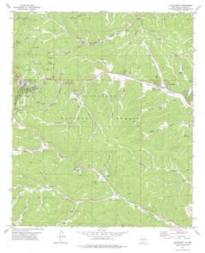
Cloudcroft Topo Map New Mexico
To zoom in, hover over the map of Cloudcroft
USGS Topo Quad 32105h6 - 1:24,000 scale
| Topo Map Name: | Cloudcroft |
| USGS Topo Quad ID: | 32105h6 |
| Print Size: | ca. 21 1/4" wide x 27" high |
| Southeast Coordinates: | 32.875° N latitude / 105.625° W longitude |
| Map Center Coordinates: | 32.9375° N latitude / 105.6875° W longitude |
| U.S. State: | NM |
| Filename: | o32105h6.jpg |
| Download Map JPG Image: | Cloudcroft topo map 1:24,000 scale |
| Map Type: | Topographic |
| Topo Series: | 7.5´ |
| Map Scale: | 1:24,000 |
| Source of Map Images: | United States Geological Survey (USGS) |
| Alternate Map Versions: |
Cloudcroft NM 1977, updated 1978 Download PDF Buy paper map Cloudcroft NM 2004, updated 2006 Download PDF Buy paper map Cloudcroft NM 2011 Download PDF Buy paper map Cloudcroft NM 2013 Download PDF Buy paper map Cloudcroft NM 2017 Download PDF Buy paper map |
| FStopo: | US Forest Service topo Cloudcroft is available: Download FStopo PDF Download FStopo TIF |
1:24,000 Topo Quads surrounding Cloudcroft
> Back to 32105e1 at 1:100,000 scale
> Back to 32104a1 at 1:250,000 scale
> Back to U.S. Topo Maps home
Cloudcroft topo map: Gazetteer
Cloudcroft: Bridges
Mexican Canyon Railroad Trestle Historic Site elevation 2642m 8667′Cloudcroft: Mines
Cloudcroft C335 elevation 2683m 8802′Cloudcroft: Parks
Cloud Climbing Railroad Historical Marker elevation 2642m 8667′Zenith Park elevation 2640m 8661′
Cloudcroft: Populated Places
Chippeway Park elevation 2516m 8254′Cloudcroft elevation 2642m 8667′
Wimsatt elevation 2399m 7870′
Cloudcroft: Post Offices
Cloudcroft Post Office elevation 2642m 8667′Cloudcroft: Reservoirs
Forks Tank elevation 2499m 8198′Grainery Tank elevation 2515m 8251′
Potato Tank elevation 2525m 8284′
Cloudcroft: Springs
Bird Spring elevation 2533m 8310′Fite Spring elevation 2520m 8267′
Johnson Spring elevation 2460m 8070′
Little Hay Spring elevation 2406m 7893′
Silver Spring elevation 2572m 8438′
Slough Spring elevation 2424m 7952′
Cloudcroft: Trails
Cascade Ski Trail elevation 2541m 8336′Cloud Nine Ski Trail elevation 2541m 8336′
Coyote Ski Trail elevation 2541m 8336′
Cross Tie Ski Trail elevation 2541m 8336′
El Oso Ski Trail elevation 2541m 8336′
Franks Plunge Ski Trail elevation 2541m 8336′
Little Lift Ski Trail elevation 2541m 8336′
Lumber Jack Ski Trail elevation 2541m 8336′
Narrow Gauge Ski Trail elevation 2541m 8336′
Pancho Villa Ski Trail elevation 2541m 8336′
Penny Whistle Ski Trail elevation 2541m 8336′
Pumphouse Ski Trail elevation 2541m 8336′
Quick Silver Ski Trail elevation 2541m 8336′
Rebeccas Revenge Ski Trail elevation 2541m 8336′
Red Dog Ski Trail elevation 2541m 8336′
Roadrunner Ski Trail elevation 2541m 8336′
Short Ski Trail elevation 2541m 8336′
Silver Spoon Ski Trail elevation 2541m 8336′
Snow Canyon Ski Trail elevation 2541m 8336′
The Cloud Climber Ski Trail elevation 2541m 8336′
The Couplings Ski Trail elevation 2541m 8336′
The Springs Ski Trail elevation 2541m 8336′
Thumper Ski Trail elevation 2541m 8336′
Trestle Ski Trail elevation 2541m 8336′
Whistle Ski Trail elevation 2541m 8336′
Cloudcroft: Valleys
Apache Canyon elevation 2583m 8474′Bradford Canyon elevation 2571m 8435′
Dry Canyon elevation 2361m 7746′
Fite Canyon elevation 2427m 7962′
Goodsell Canyon elevation 2549m 8362′
Jones Canyon elevation 2426m 7959′
Kerr Canyon elevation 2587m 8487′
Little Apache Canyon elevation 2591m 8500′
Lucas Canyon elevation 2453m 8047′
Orr Canyon elevation 2447m 8028′
Painter Canyon elevation 2418m 7933′
Peake Canyon elevation 2535m 8316′
Pierce Canyon elevation 2575m 8448′
Pumphouse Canyon elevation 2525m 8284′
Rawlins Canyon elevation 2560m 8398′
Russia Canyon elevation 2384m 7821′
Slough Canyon elevation 2330m 7644′
Spud Patch Canyon elevation 2434m 7985′
Sullivan Canyon elevation 2344m 7690′
Turkey Pen Canyon elevation 2425m 7956′
Wayne Canyon elevation 2565m 8415′
Young Canyon elevation 2442m 8011′
Cloudcroft digital topo map on disk
Buy this Cloudcroft topo map showing relief, roads, GPS coordinates and other geographical features, as a high-resolution digital map file on DVD:


