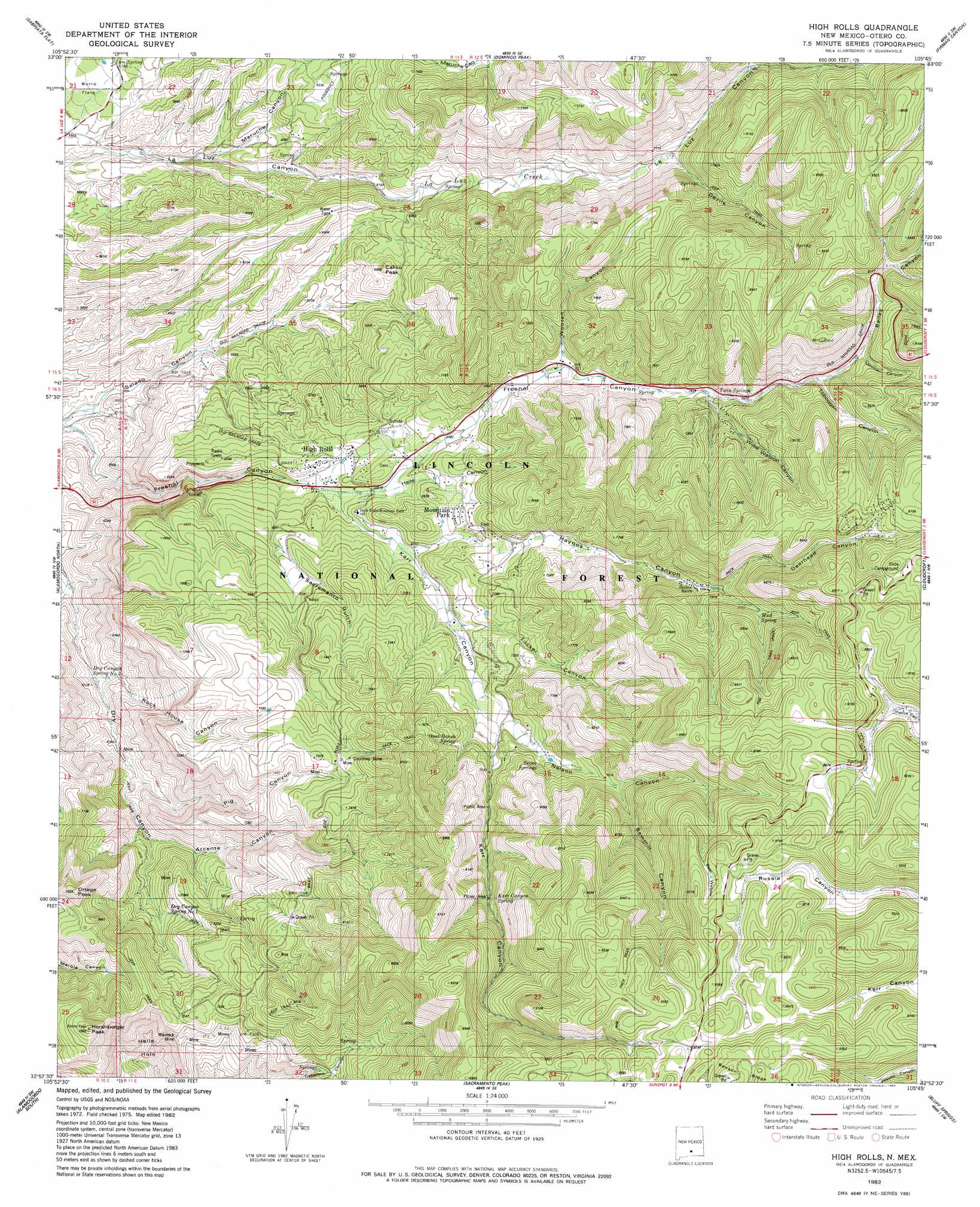
High Rolls Topo Map New Mexico
To zoom in, hover over the map of High Rolls
USGS Topo Quad 32105h7 - 1:24,000 scale
| Topo Map Name: | High Rolls |
| USGS Topo Quad ID: | 32105h7 |
| Print Size: | ca. 21 1/4" wide x 27" high |
| Southeast Coordinates: | 32.875° N latitude / 105.75° W longitude |
| Map Center Coordinates: | 32.9375° N latitude / 105.8125° W longitude |
| U.S. State: | NM |
| Filename: | o32105h7.jpg |
| Download Map JPG Image: | High Rolls topo map 1:24,000 scale |
| Map Type: | Topographic |
| Topo Series: | 7.5´ |
| Map Scale: | 1:24,000 |
| Source of Map Images: | United States Geological Survey (USGS) |
| Alternate Map Versions: |
High Rolls NM 1982, updated 1982 Download PDF Buy paper map High Rolls NM 2004, updated 2006 Download PDF Buy paper map High Rolls NM 2011 Download PDF Buy paper map High Rolls NM 2013 Download PDF Buy paper map High Rolls NM 2017 Download PDF Buy paper map |
| FStopo: | US Forest Service topo High Rolls is available: Download FStopo PDF Download FStopo TIF |
1:24,000 Topo Quads surrounding High Rolls
Tularosa Ne |
Cat Mountain |
Mescalero |
Apache Summit |
Whitetail |
Tularosa |
Sabinata Flat |
Domingo Peak |
Firman Canyon |
Elk-Silver |
Malone Draw |
Alamogordo North |
High Rolls |
Cloudcroft |
Harvey Ranch |
Holloman |
Alamogordo South |
Sacramento Peak |
Bluff Springs |
Sacramento |
Tres Hermanos |
Deadman Canyon |
Bug Scuffle Canyon |
Rogers Ruins |
Bear Spring |
> Back to 32105e1 at 1:100,000 scale
> Back to 32104a1 at 1:250,000 scale
> Back to U.S. Topo Maps home
High Rolls topo map: Gazetteer
High Rolls: Mines
Black Bear elevation 2197m 7208′Courtney Mine elevation 2322m 7618′
Courtney Mine elevation 2294m 7526′
Luz Prospects elevation 2189m 7181′
Warnock Mine elevation 2164m 7099′
High Rolls: Populated Places
High Rolls elevation 2002m 6568′Mountain Park elevation 2043m 6702′
High Rolls: Post Offices
Mountain Park Post Office (historical) elevation 2043m 6702′High Rolls: Springs
Dry Canyon Spring elevation 2051m 6729′Dry Canyon Spring Number One elevation 2051m 6729′
Dry Canyon Spring Number Two elevation 1928m 6325′
Goat Ranch Spring elevation 2245m 7365′
Karr Canyon Spring elevation 2431m 7975′
Mud Spring elevation 2465m 8087′
Seven Springs elevation 2265m 7431′
Twin Springs elevation 2294m 7526′
High Rolls: Summits
Calico Peak elevation 2024m 6640′Hershberger Peak elevation 2325m 7627′
Ortega Peak elevation 2334m 7657′
Red Hill elevation 2038m 6686′
High Rolls: Trails
Osha Trail elevation 2614m 8576′High Rolls: Valleys
Arcente Canyon elevation 1963m 6440′Bailey Canyon elevation 2415m 7923′
Bear Wallow elevation 2519m 8264′
Caballero Canyon elevation 2210m 7250′
Deerhead Canyon elevation 2616m 8582′
Devils Canyon elevation 2229m 7312′
Haile Canyon elevation 2013m 6604′
Haynes Canyon elevation 2043m 6702′
Karr Canyon elevation 2000m 6561′
Maruche Canyon elevation 1754m 5754′
Mexican Canyon elevation 2375m 7791′
Nelson Canyon elevation 2165m 7103′
Pig Canyon elevation 1916m 6286′
Rock House Canyon elevation 1838m 6030′
Sacramento Gulch elevation 2048m 6719′
Salado Canyon elevation 1693m 5554′
Sawmill Canyon elevation 2328m 7637′
Toboggan Canyon elevation 2351m 7713′
Tucker Canyon elevation 2084m 6837′
Willie Watson Canyon elevation 2259m 7411′
Wooten Canyon elevation 2167m 7109′
High Rolls digital topo map on disk
Buy this High Rolls topo map showing relief, roads, GPS coordinates and other geographical features, as a high-resolution digital map file on DVD: