Bishop Cap Topo Map New Mexico
To zoom in, hover over the map of Bishop Cap
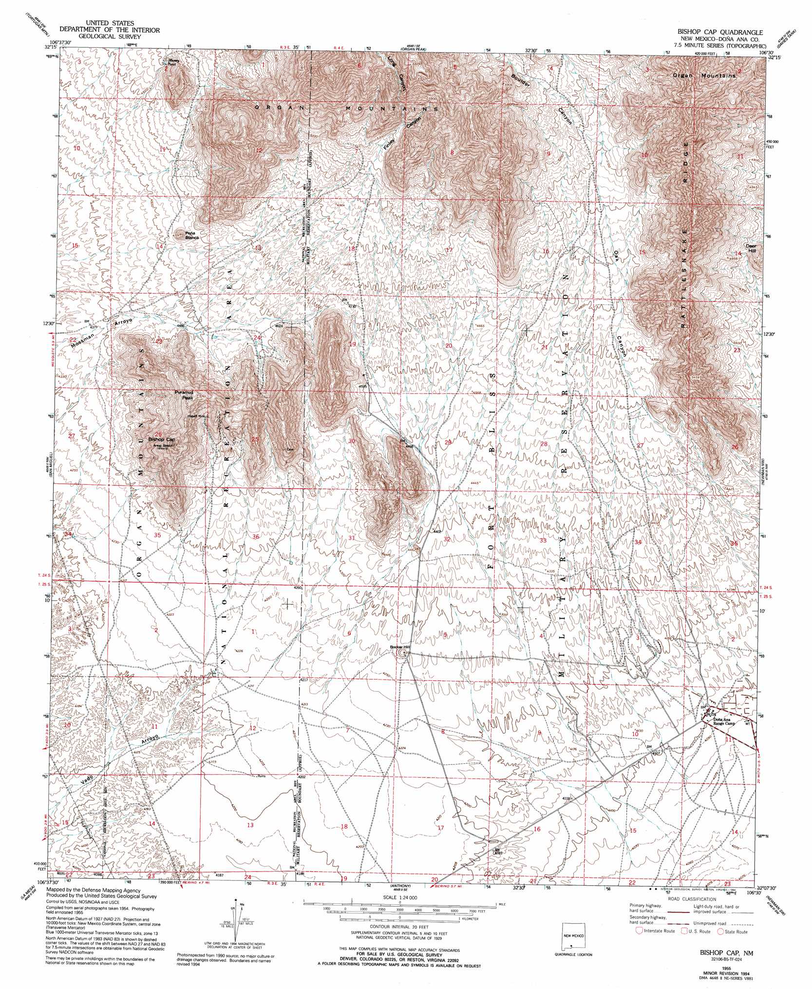
USGS Topo Quad 32106b5 - 1:24,000 scale
| Topo Map Name: | Bishop Cap |
| USGS Topo Quad ID: | 32106b5 |
| Print Size: | ca. 21 1/4" wide x 27" high |
| Southeast Coordinates: | 32.125° N latitude / 106.5° W longitude |
| Map Center Coordinates: | 32.1875° N latitude / 106.5625° W longitude |
| U.S. State: | NM |
| Filename: | o32106b5.jpg |
| Download Map JPG Image: | Bishop Cap topo map 1:24,000 scale |
| Map Type: | Topographic |
| Topo Series: | 7.5´ |
| Map Scale: | 1:24,000 |
| Source of Map Images: | United States Geological Survey (USGS) |
| Alternate Map Versions: |
Bishop Cap NM 1955, updated 1962 Download PDF Buy paper map Bishop Cap NM 1955, updated 1994 Download PDF Buy paper map Bishop Cap NM 1996, updated 2001 Download PDF Buy paper map Bishop Cap NM 2010 Download PDF Buy paper map Bishop Cap NM 2013 Download PDF Buy paper map Bishop Cap NM 2017 Download PDF Buy paper map |
1:24,000 Topo Quads surrounding Bishop Cap
Dona Ana |
Organ Peak Nw |
Organ |
White Sands |
White Sands Ne |
Las Cruces |
Tortugas Mountain |
Organ Peak |
Davies Tank |
White Sands Se |
Black Mesa |
San Miguel |
Bishop Cap |
Newman Nw |
Newman Ne |
Little Black Mountain |
La Mesa |
Anthony |
Newman Sw |
Newman |
Lanark |
La Union |
Canutillo |
North Franklin Mountain |
Fort Bliss Ne |
> Back to 32106a1 at 1:100,000 scale
> Back to 32106a1 at 1:250,000 scale
> Back to U.S. Topo Maps home
Bishop Cap topo map: Gazetteer
Bishop Cap: Mines
Bishops Cap Mine elevation 1495m 4904′Blue Star elevation 1522m 4993′
Blue Star Prospect elevation 1533m 5029′
Brick Shale elevation 1332m 4370′
Conklings Cave elevation 1465m 4806′
Grant Prospect elevation 1511m 4957′
Herbert Mine elevation 1426m 4678′
Bishop Cap: Reservoirs
Massey Tank elevation 1433m 4701′Bishop Cap: Ridges
Rattlesnake Ridge elevation 1832m 6010′Bishop Cap: Summits
Bishop Cap elevation 1651m 5416′Booker Hill elevation 1319m 4327′
Deer Hill elevation 1527m 5009′
Peña Blanca elevation 1426m 4678′
Pyramid Peak elevation 1597m 5239′
Bishop Cap: Valleys
Boulder Canyon elevation 1560m 5118′Finley Canyon elevation 1372m 4501′
Long Canyon elevation 1599m 5246′
Bishop Cap: Wells
10108 Water Well elevation 1296m 4251′10115 Water Well elevation 1284m 4212′
19 Water Well elevation 1244m 4081′
K 15 Water Well elevation 1244m 4081′
K-14 Water Well elevation 1272m 4173′
Number 1 Water Well elevation 1281m 4202′
Bishop Cap digital topo map on disk
Buy this Bishop Cap topo map showing relief, roads, GPS coordinates and other geographical features, as a high-resolution digital map file on DVD: