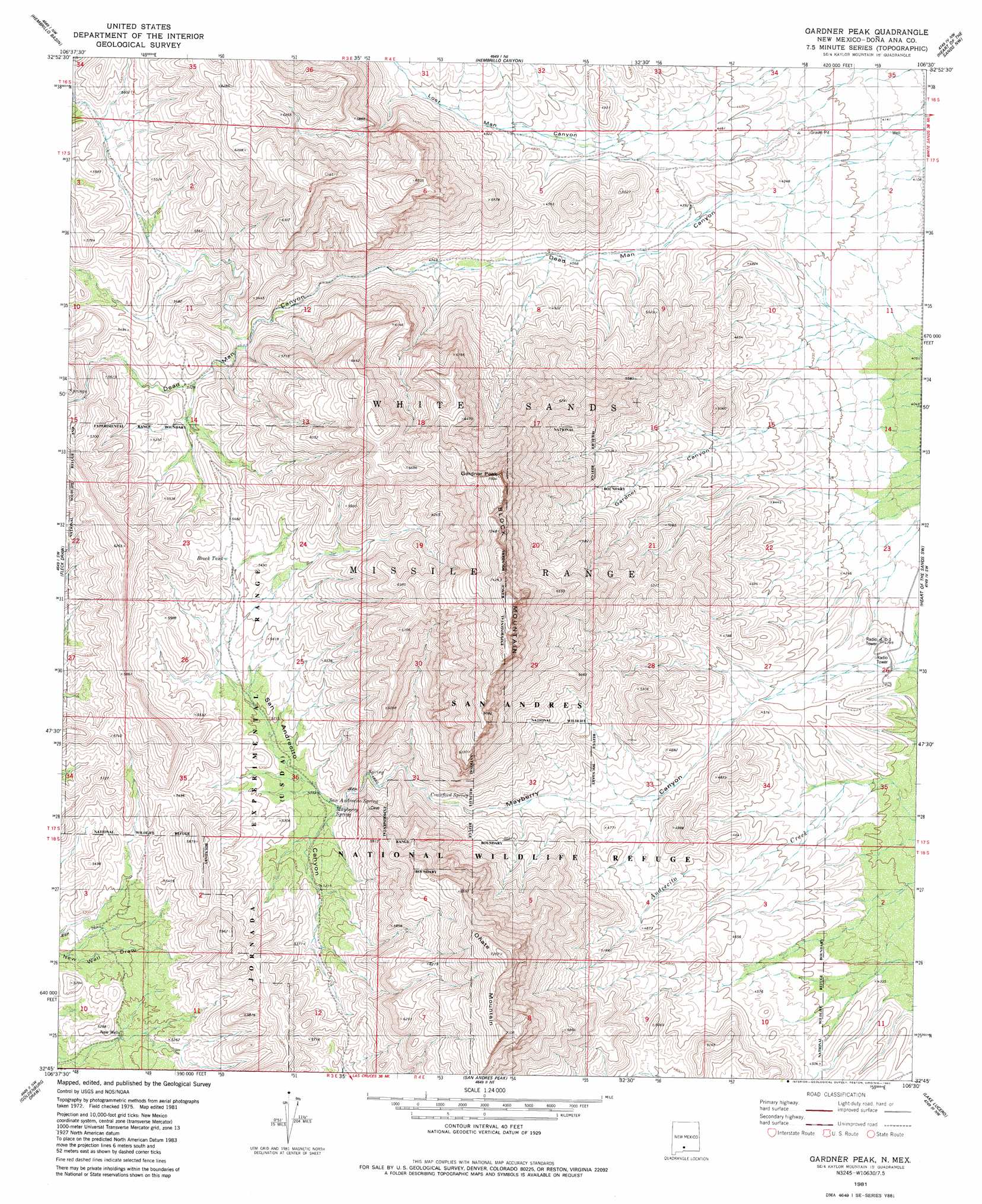
Gardner Peak Topo Map New Mexico
To zoom in, hover over the map of Gardner Peak
USGS Topo Quad 32106g5 - 1:24,000 scale
| Topo Map Name: | Gardner Peak |
| USGS Topo Quad ID: | 32106g5 |
| Print Size: | ca. 21 1/4" wide x 27" high |
| Southeast Coordinates: | 32.75° N latitude / 106.5° W longitude |
| Map Center Coordinates: | 32.8125° N latitude / 106.5625° W longitude |
| U.S. State: | NM |
| Filename: | o32106g5.jpg |
| Download Map JPG Image: | Gardner Peak topo map 1:24,000 scale |
| Map Type: | Topographic |
| Topo Series: | 7.5´ |
| Map Scale: | 1:24,000 |
| Source of Map Images: | United States Geological Survey (USGS) |
| Alternate Map Versions: |
Gardner Peak NM 1981, updated 1981 Download PDF Buy paper map Gardner Peak NM 1996, updated 2002 Download PDF Buy paper map Gardner Peak NM 2010 Download PDF Buy paper map Gardner Peak NM 2013 Download PDF Buy paper map Gardner Peak NM 2017 Download PDF Buy paper map |
1:24,000 Topo Quads surrounding Gardner Peak
Dugout Canyon |
Sulphur Pass |
Strawberry Peak |
Lumley Lake |
Fifteenmile Lake |
Prisor Well |
Hembrillo Basin |
Hembrillo Canyon |
Heart Of The Sands Nw |
Heart Of The Sands Ne |
Gilmore Draw |
Fleck Draw |
Gardner Peak |
Heart Of The Sands Sw |
Heart Of The Sands |
Seldon Canyon Ne |
Goldenburg Draw |
San Andres Peak |
Lake Lucero |
Lake Lucero Ne |
Summerford Mountain |
Taylor Well |
Bear Peak |
Bennett Mountain |
Lake Lucero Se |
> Back to 32106e1 at 1:100,000 scale
> Back to 32106a1 at 1:250,000 scale
> Back to U.S. Topo Maps home
Gardner Peak topo map: Gazetteer
Gardner Peak: Mines
Andrecito elevation 1300m 4265′Green Crawford elevation 1577m 5173′
Gardner Peak: Reservoirs
Brock Tank elevation 1659m 5442′Gardner Peak: Springs
Crawford Spring elevation 1486m 4875′Mayberry Spring elevation 1539m 5049′
San Adrecito Spring elevation 1546m 5072′
Gardner Peak: Summits
Block Mountain elevation 2216m 7270′Gardner Peak elevation 2171m 7122′
Onate Mountain elevation 1905m 6250′
Gardner Peak: Valleys
Dead Man Canyon elevation 1311m 4301′Gardner Canyon elevation 1341m 4399′
Lead Camp Canyon elevation 1712m 5616′
Lost Man Canyon elevation 1292m 4238′
Mayberry Canyon elevation 1291m 4235′
San Andrecito Canyon elevation 1707m 5600′
Gardner Peak: Wells
New Well elevation 1564m 5131′Gardner Peak digital topo map on disk
Buy this Gardner Peak topo map showing relief, roads, GPS coordinates and other geographical features, as a high-resolution digital map file on DVD: