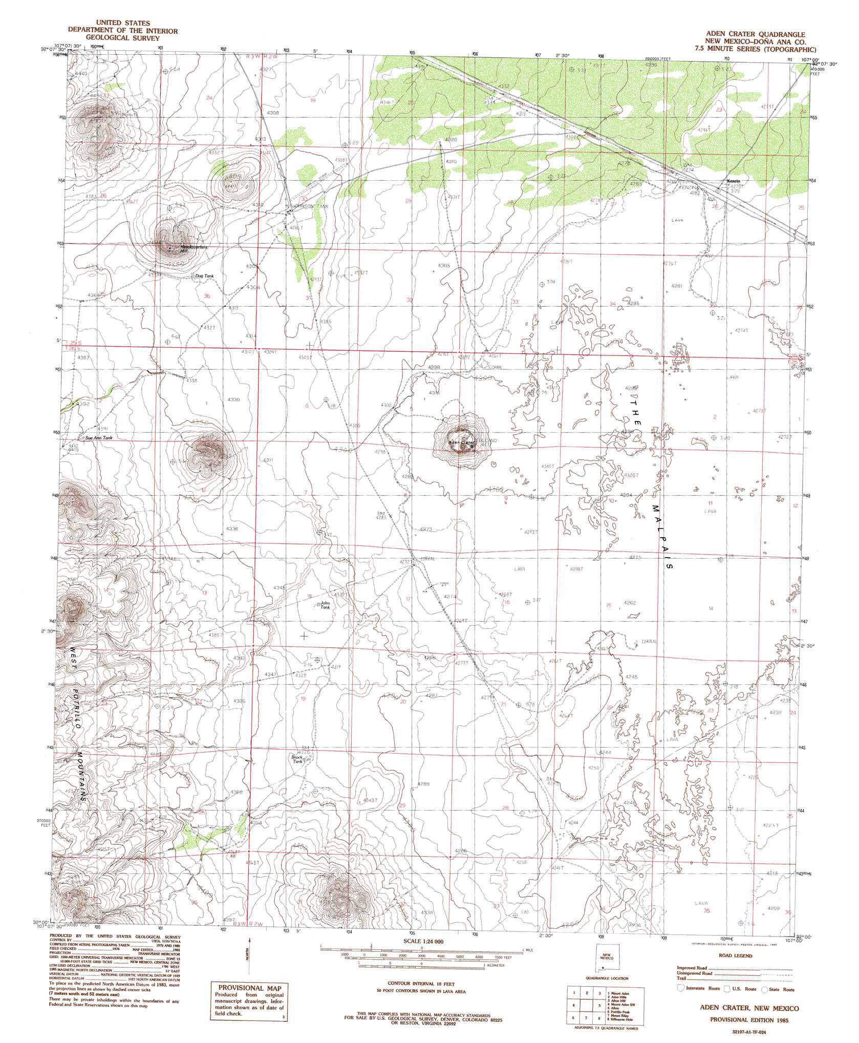
Aden Crater Topo Map New Mexico
To zoom in, hover over the map of Aden Crater
USGS Topo Quad 32107a1 - 1:24,000 scale
| Topo Map Name: | Aden Crater |
| USGS Topo Quad ID: | 32107a1 |
| Print Size: | ca. 21 1/4" wide x 27" high |
| Southeast Coordinates: | 32° N latitude / 107° W longitude |
| Map Center Coordinates: | 32.0625° N latitude / 107.0625° W longitude |
| U.S. State: | NM |
| Filename: | o32107a1.jpg |
| Download Map JPG Image: | Aden Crater topo map 1:24,000 scale |
| Map Type: | Topographic |
| Topo Series: | 7.5´ |
| Map Scale: | 1:24,000 |
| Source of Map Images: | United States Geological Survey (USGS) |
| Alternate Map Versions: |
Aden Crater NM 1985, updated 1985 Download PDF Buy paper map Aden Crater NM 1996, updated 2001 Download PDF Buy paper map Aden Crater NM 2010 Download PDF Buy paper map Aden Crater NM 2013 Download PDF Buy paper map Aden Crater NM 2017 Download PDF Buy paper map |
1:24,000 Topo Quads surrounding Aden Crater
Lazy E Ranch |
Magdalena Gap |
Sleeping Lady Hills |
Picacho Mountain |
Las Cruces |
Cambray |
Mount Aden |
Aden Hills |
Afton Nw |
Black Mesa |
X-7 Ranch |
Mount Aden Sw |
Aden Crater |
Afton |
Little Black Mountain |
P O L Ranch |
Potrillo Peak |
Mount Riley |
Kilbourne Hole |
Lanark |
Camel Mountain |
Guzmans Lookout Mountain |
Mount Riley Se |
Potrillo |
Noria |
> Back to 32107a1 at 1:100,000 scale
> Back to 32106a1 at 1:250,000 scale
> Back to U.S. Topo Maps home
Aden Crater topo map: Gazetteer
Aden Crater: Basins
Aden Crater elevation 1346m 4416′Aden Crater: Parks
Aden Lava Flow Wilderness Study Area elevation 1346m 4416′Aden Crater: Populated Places
Kenzin elevation 1303m 4274′Pronto elevation 1325m 4347′
Aden Crater: Reservoirs
Brock Tank elevation 1318m 4324′John Tank elevation 1313m 4307′
Johnson Ranch Tank elevation 1307m 4288′
New Tank elevation 1313m 4307′
Sue Anne Tank elevation 1341m 4399′
Aden Crater: Summits
Headquarters Hill elevation 1344m 4409′Aden Crater: Wells
The Tub elevation 1304m 4278′Aden Crater digital topo map on disk
Buy this Aden Crater topo map showing relief, roads, GPS coordinates and other geographical features, as a high-resolution digital map file on DVD: