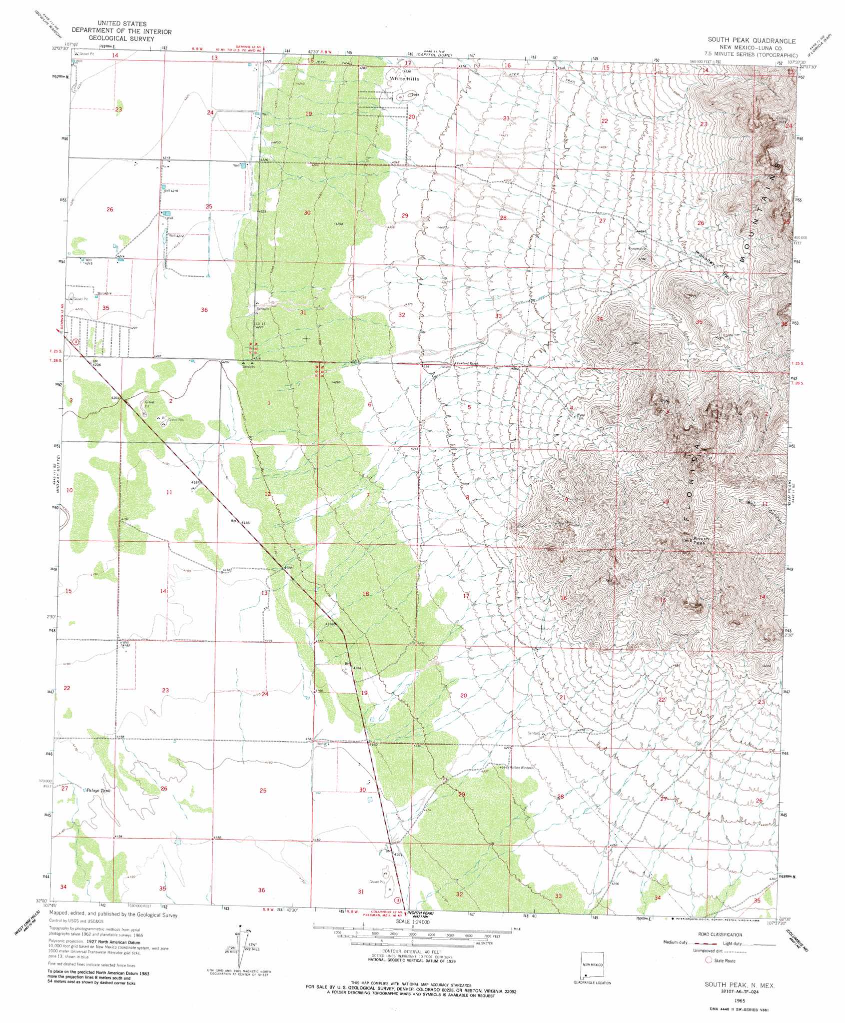
South Peak Topo Map New Mexico
To zoom in, hover over the map of South Peak
USGS Topo Quad 32107a6 - 1:24,000 scale
| Topo Map Name: | South Peak |
| USGS Topo Quad ID: | 32107a6 |
| Print Size: | ca. 21 1/4" wide x 27" high |
| Southeast Coordinates: | 32° N latitude / 107.625° W longitude |
| Map Center Coordinates: | 32.0625° N latitude / 107.6875° W longitude |
| U.S. State: | NM |
| Filename: | o32107a6.jpg |
| Download Map JPG Image: | South Peak topo map 1:24,000 scale |
| Map Type: | Topographic |
| Topo Series: | 7.5´ |
| Map Scale: | 1:24,000 |
| Source of Map Images: | United States Geological Survey (USGS) |
| Alternate Map Versions: |
South Peak NM 1965, updated 1966 Download PDF Buy paper map South Peak NM 1965, updated 1986 Download PDF Buy paper map South Peak NM 1996, updated 2002 Download PDF Buy paper map South Peak NM 2010 Download PDF Buy paper map South Peak NM 2013 Download PDF Buy paper map |
1:24,000 Topo Quads surrounding South Peak
Williams Ranch |
Deming West |
Deming East |
Carne |
Myndus |
Red Mountain |
Bowlin Ranch |
Capitol Dome |
Florida Gap |
Akela |
Bisbee Hills |
Midway Butte |
South Peak |
Gym Peak |
Sibley Hole |
Hermanas Nw |
West Lime Hills |
North Peak |
Columbus Ne |
Mesquite Lake |
Hermanas |
Malpais Hill |
Columbus |
Columbus Se |
Coyote Hill |
> Back to 32107a1 at 1:100,000 scale
> Back to 32106a1 at 1:250,000 scale
> Back to U.S. Topo Maps home
South Peak topo map: Gazetteer
South Peak: Flats
Mahoney Park elevation 1576m 5170′South Peak: Mines
Big Pocket-Florida Mountains Area elevation 1795m 5889′Park elevation 1605m 5265′
Shaw Prospect elevation 1611m 5285′
South Side elevation 1450m 4757′
South Peak: Reservoirs
Palayo Tank elevation 1269m 4163′South Peak: Summits
South Peak elevation 2156m 7073′White Hills elevation 1343m 4406′
South Peak: Wells
00659 Water Well elevation 1583m 5193′00660 Water Well elevation 1362m 4468′
00718 Water Well elevation 1290m 4232′
00719 Water Well elevation 1290m 4232′
00720 Water Well elevation 1286m 4219′
00721 Water Well elevation 1289m 4229′
00722 Water Well elevation 1285m 4215′
00725 Water Well elevation 1285m 4215′
00726 Water Well elevation 1285m 4215′
00804 Water Well elevation 1297m 4255′
00806 Water Well elevation 1276m 4186′
00807 Water Well elevation 1293m 4242′
00808 Water Well elevation 1273m 4176′
00811 Water Well elevation 1297m 4255′
00812 Water Well elevation 1268m 4160′
00813 Water Well elevation 1269m 4163′
00814 Water Well elevation 1269m 4163′
00828 Water Well elevation 1277m 4189′
00829 Water Well elevation 1277m 4189′
00832 Water Well elevation 1277m 4189′
00837 Water Well elevation 1275m 4183′
01436 Water Well elevation 1274m 4179′
06011 Water Well elevation 1273m 4176′
06146 Water Well elevation 1313m 4307′
10306 Water Well elevation 1313m 4307′
10326 Water Well elevation 1286m 4219′
10327 Water Well elevation 1286m 4219′
10328 Water Well elevation 1286m 4219′
10329 Water Well elevation 1286m 4219′
10338 Water Well elevation 1285m 4215′
10339 Water Well elevation 1285m 4215′
10349 Water Well elevation 1269m 4163′
10350 Water Well elevation 1282m 4206′
10352 Water Well elevation 1278m 4192′
South Peak digital topo map on disk
Buy this South Peak topo map showing relief, roads, GPS coordinates and other geographical features, as a high-resolution digital map file on DVD: