Mount Aden Topo Map New Mexico
To zoom in, hover over the map of Mount Aden
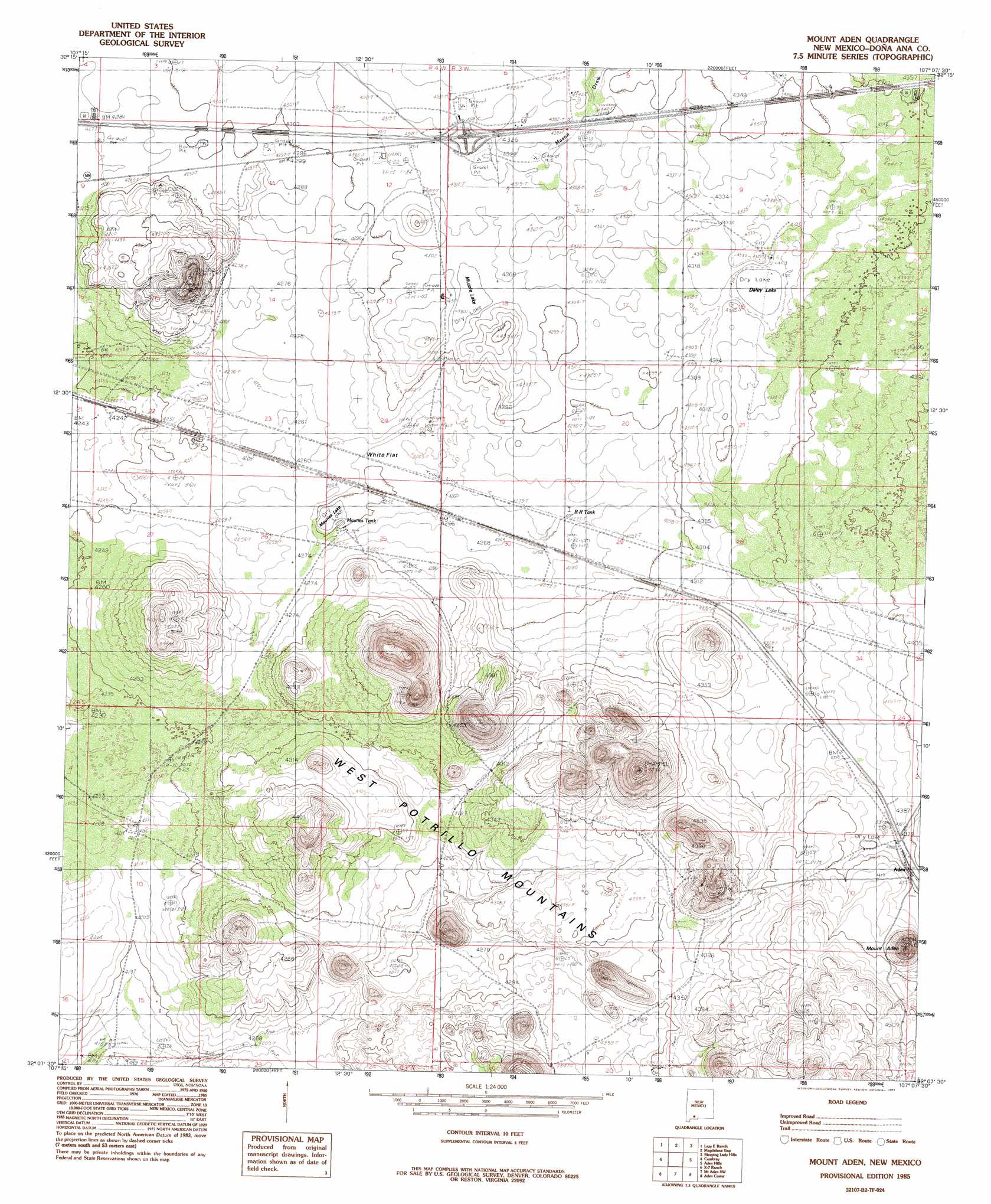
USGS Topo Quad 32107b2 - 1:24,000 scale
| Topo Map Name: | Mount Aden |
| USGS Topo Quad ID: | 32107b2 |
| Print Size: | ca. 21 1/4" wide x 27" high |
| Southeast Coordinates: | 32.125° N latitude / 107.125° W longitude |
| Map Center Coordinates: | 32.1875° N latitude / 107.1875° W longitude |
| U.S. State: | NM |
| Filename: | o32107b2.jpg |
| Download Map JPG Image: | Mount Aden topo map 1:24,000 scale |
| Map Type: | Topographic |
| Topo Series: | 7.5´ |
| Map Scale: | 1:24,000 |
| Source of Map Images: | United States Geological Survey (USGS) |
| Alternate Map Versions: |
Mount Aden NM 1985, updated 1985 Download PDF Buy paper map Mount Aden NM 1996, updated 2001 Download PDF Buy paper map Mount Aden NM 2010 Download PDF Buy paper map Mount Aden NM 2013 Download PDF Buy paper map Mount Aden NM 2017 Download PDF Buy paper map |
1:24,000 Topo Quads surrounding Mount Aden
Good Sight Peak |
Good Sight Peak Ne |
Magdalena Peak |
Rough And Ready Hills |
Leasburg |
Myndus |
Lazy E Ranch |
Magdalena Gap |
Sleeping Lady Hills |
Picacho Mountain |
Akela |
Cambray |
Mount Aden |
Aden Hills |
Afton Nw |
Sibley Hole |
X-7 Ranch |
Mount Aden Sw |
Aden Crater |
Afton |
Mesquite Lake |
P O L Ranch |
Potrillo Peak |
Mount Riley |
Kilbourne Hole |
> Back to 32107a1 at 1:100,000 scale
> Back to 32106a1 at 1:250,000 scale
> Back to U.S. Topo Maps home
Mount Aden topo map: Gazetteer
Mount Aden: Airports
Burris E Station Airport elevation 1321m 4333′Mount Aden: Flats
White Flat elevation 1299m 4261′Mount Aden: Lakes
Dalry Lake elevation 1319m 4327′Mauries Lake elevation 1295m 4248′
Muzzle Lake elevation 1313m 4307′
Mount Aden: Populated Places
Aden elevation 1339m 4393′Chappel elevation 1302m 4271′
Mount Aden: Post Offices
Aden Post Office (historical) elevation 1339m 4393′Mount Aden: Reservoirs
Mauries Tank elevation 1295m 4248′R R Tank elevation 1304m 4278′
Mount Aden: Summits
Aden Mountain elevation 1434m 4704′Mount Aden: Valleys
Mason Draw elevation 1314m 4311′Mount Aden: Wells
Biggs Wells elevation 1270m 4166′Lazy E Bar Water Well elevation 1297m 4255′
New Pipeline Tub elevation 1317m 4320′
West Line Well elevation 1318m 4324′
Mount Aden digital topo map on disk
Buy this Mount Aden topo map showing relief, roads, GPS coordinates and other geographical features, as a high-resolution digital map file on DVD: