Rough And Ready Hills Topo Map New Mexico
To zoom in, hover over the map of Rough And Ready Hills
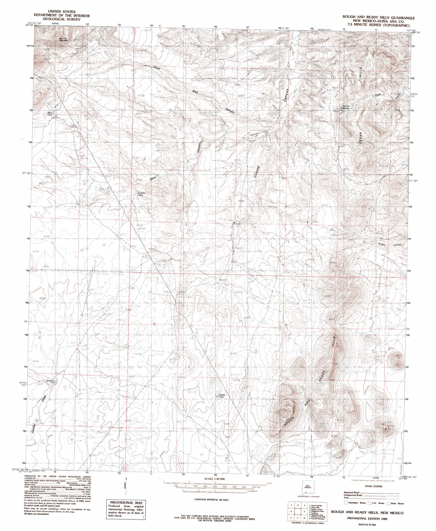
USGS Topo Quad 32107d1 - 1:24,000 scale
| Topo Map Name: | Rough And Ready Hills |
| USGS Topo Quad ID: | 32107d1 |
| Print Size: | ca. 21 1/4" wide x 27" high |
| Southeast Coordinates: | 32.375° N latitude / 107° W longitude |
| Map Center Coordinates: | 32.4375° N latitude / 107.0625° W longitude |
| U.S. State: | NM |
| Filename: | o32107d1.jpg |
| Download Map JPG Image: | Rough And Ready Hills topo map 1:24,000 scale |
| Map Type: | Topographic |
| Topo Series: | 7.5´ |
| Map Scale: | 1:24,000 |
| Source of Map Images: | United States Geological Survey (USGS) |
| Alternate Map Versions: |
Rough And Ready Hills NM 1985, updated 1985 Download PDF Buy paper map Rough And Ready Hills NM 2001, updated 2001 Download PDF Buy paper map Rough and Ready Hills NM 2010 Download PDF Buy paper map Rough and Ready Hills NM 2013 Download PDF Buy paper map Rough and Ready Hills NM 2017 Download PDF Buy paper map |
1:24,000 Topo Quads surrounding Rough And Ready Hills
Arroyo Cuervo |
Hatch |
Rincon |
Thorn Well |
Seldon Canyon Ne |
Hockett |
Souse Springs |
Sierra Alta |
Seldon Canyon |
Summerford Mountain |
Good Sight Peak Ne |
Magdalena Peak |
Rough And Ready Hills |
Leasburg |
Dona Ana |
Lazy E Ranch |
Magdalena Gap |
Sleeping Lady Hills |
Picacho Mountain |
Las Cruces |
Cambray |
Mount Aden |
Aden Hills |
Afton Nw |
Black Mesa |
> Back to 32107a1 at 1:100,000 scale
> Back to 32106a1 at 1:250,000 scale
> Back to U.S. Topo Maps home
Rough And Ready Hills topo map: Gazetteer
Rough And Ready Hills: Dams
Las Uvas Number Five Dam elevation 1453m 4767′Las Uvas Number Four Dam elevation 1444m 4737′
Las Uvas Number One Dam elevation 1415m 4642′
Las Uvas Number Six Dam elevation 1372m 4501′
Rough And Ready Hills: Ranges
Cedar Hills elevation 1453m 4767′Rough and Ready Hills elevation 1589m 5213′
Rough And Ready Hills: Reservoirs
Adobe Tank elevation 1440m 4724′Bill Shaw Tank elevation 1388m 4553′
Coyote Tank elevation 1426m 4678′
Marijuana Tank elevation 1405m 4609′
McCall Reservoir elevation 1360m 4461′
Silva Tank elevation 1480m 4855′
Rough And Ready Hills: Summits
Bell Top Mountain elevation 1722m 5649′Rough And Ready Hills: Valleys
Silva Canyon elevation 1364m 4475′Rough And Ready Hills: Wells
Adobe Ranch Water Well elevation 1439m 4721′Lloyd Well elevation 1452m 4763′
Rough And Ready Hills digital topo map on disk
Buy this Rough And Ready Hills topo map showing relief, roads, GPS coordinates and other geographical features, as a high-resolution digital map file on DVD: