Nutt Topo Map New Mexico
To zoom in, hover over the map of Nutt
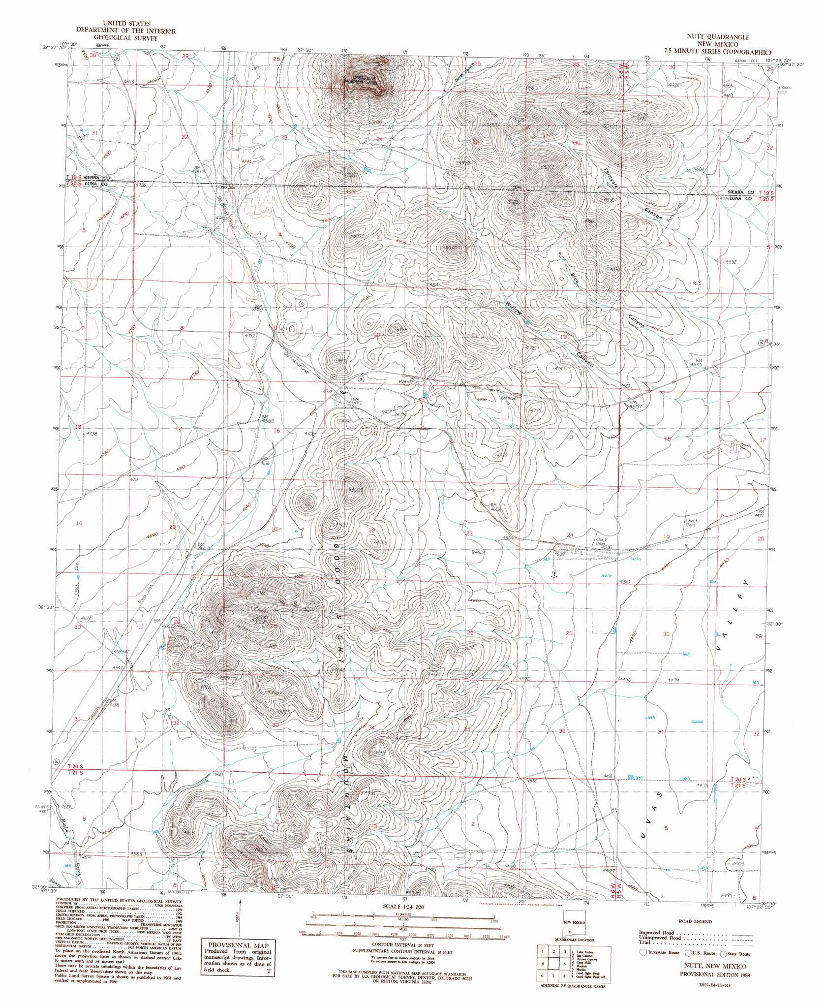
USGS Topo Quad 32107e4 - 1:24,000 scale
| Topo Map Name: | Nutt |
| USGS Topo Quad ID: | 32107e4 |
| Print Size: | ca. 21 1/4" wide x 27" high |
| Southeast Coordinates: | 32.5° N latitude / 107.375° W longitude |
| Map Center Coordinates: | 32.5625° N latitude / 107.4375° W longitude |
| U.S. State: | NM |
| Filename: | o32107e4.jpg |
| Download Map JPG Image: | Nutt topo map 1:24,000 scale |
| Map Type: | Topographic |
| Topo Series: | 7.5´ |
| Map Scale: | 1:24,000 |
| Source of Map Images: | United States Geological Survey (USGS) |
| Alternate Map Versions: |
Nutt NM 1989, updated 1989 Download PDF Buy paper map Nutt NM 2010 Download PDF Buy paper map Nutt NM 2013 Download PDF Buy paper map Nutt NM 2017 Download PDF Buy paper map |
1:24,000 Topo Quads surrounding Nutt
Pa Mountain |
Mcclede Mountain |
Clark Spring Canyon |
Garfield |
Mcleod Tank |
Whiterock Mountain |
Lake Valley |
Jug Canyon |
Arroyo Cuervo |
Hatch |
Ok Canyon |
Greg Hills |
Nutt |
Hockett |
Souse Springs |
Massacre Peak |
Florida |
Good Sight Peak |
Good Sight Peak Ne |
Magdalena Peak |
Deming East |
Carne |
Myndus |
Lazy E Ranch |
Magdalena Gap |
> Back to 32107e1 at 1:100,000 scale
> Back to 32106a1 at 1:250,000 scale
> Back to U.S. Topo Maps home
Nutt topo map: Gazetteer
Nutt: Populated Places
Nutt elevation 1439m 4721′Nutt: Post Offices
Nutt Post Office elevation 1439m 4721′Nutt: Summits
Nutt Mountain elevation 1781m 5843′Nutt: Valleys
Blue Canyon elevation 1381m 4530′Uvas Valley elevation 1363m 4471′
Willow Canyon elevation 1371m 4498′
Nutt: Wells
01501 Water Well elevation 1441m 4727′01502 Water Well elevation 1434m 4704′
01503 Water Well elevation 1409m 4622′
06155 Water Well elevation 1460m 4790′
10003 Water Well elevation 1366m 4481′
10004 Water Well elevation 1366m 4481′
10005 Water Well elevation 1368m 4488′
10011 Water Well elevation 1377m 4517′
10014 Water Well elevation 1370m 4494′
10446 Water Well elevation 1374m 4507′
10449 Water Well elevation 1366m 4481′
10454 Water Well elevation 1364m 4475′
10458 Water Well elevation 1381m 4530′
10459 Water Well elevation 1369m 4491′
NH 121 Water Well elevation 1367m 4484′
NH 160 Water Well elevation 1369m 4491′
NH 83 Water Well elevation 1377m 4517′
Nutt digital topo map on disk
Buy this Nutt topo map showing relief, roads, GPS coordinates and other geographical features, as a high-resolution digital map file on DVD: