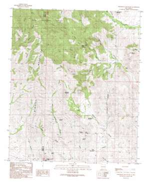
Whiterock Mountain Topo Map New Mexico
To zoom in, hover over the map of Whiterock Mountain
USGS Topo Quad 32107f6 - 1:24,000 scale
| Topo Map Name: | Whiterock Mountain |
| USGS Topo Quad ID: | 32107f6 |
| Print Size: | ca. 21 1/4" wide x 27" high |
| Southeast Coordinates: | 32.625° N latitude / 107.625° W longitude |
| Map Center Coordinates: | 32.6875° N latitude / 107.6875° W longitude |
| U.S. State: | NM |
| Filename: | o32107f6.jpg |
| Download Map JPG Image: | Whiterock Mountain topo map 1:24,000 scale |
| Map Type: | Topographic |
| Topo Series: | 7.5´ |
| Map Scale: | 1:24,000 |
| Source of Map Images: | United States Geological Survey (USGS) |
| Alternate Map Versions: |
White Rock Mountain NM 1989, updated 1989 Download PDF Buy paper map White Rock Mountain NM 1999, updated 2002 Download PDF Buy paper map Whiterock Mountain NM 2011 Download PDF Buy paper map Whiterock Mountain NM 2013 Download PDF Buy paper map Whiterock Mountain NM 2017 Download PDF Buy paper map |
| FStopo: | US Forest Service topo Whiterock Mountain is available: Download FStopo PDF Download FStopo TIF |
1:24,000 Topo Quads surrounding Whiterock Mountain
> Back to 32107e1 at 1:100,000 scale
> Back to 32106a1 at 1:250,000 scale
> Back to U.S. Topo Maps home
Whiterock Mountain topo map: Gazetteer
Whiterock Mountain: Reservoirs
Taylor Tank elevation 1950m 6397′Whiterock Mountain: Springs
Alkali Spring elevation 1731m 5679′Grapevine Spring elevation 1777m 5830′
Indian Spring elevation 1705m 5593′
Little Bear Springs elevation 1805m 5921′
Log Spring elevation 1739m 5705′
McAsh Spring elevation 1710m 5610′
Taylor Spring elevation 1785m 5856′
The Seep Spring elevation 1753m 5751′
Walnut Spring elevation 1700m 5577′
Whiterock Mountain: Streams
North Hollow Creek elevation 1727m 5666′Pollock Creek elevation 1731m 5679′
Taylor Creek elevation 1699m 5574′
Whiterock Mountain: Summits
Lee Mountain elevation 1946m 6384′Log Springs Mountain elevation 1769m 5803′
Mule Springs Peak elevation 1935m 6348′
Whiterock Mountain elevation 2005m 6578′
Whiterock Mountain: Valleys
Alkali Canyon elevation 1692m 5551′Fuller Canyon elevation 1682m 5518′
Indian Springs Canyon elevation 1655m 5429′
Outlaw Canyon elevation 1882m 6174′
Road Canyon elevation 1723m 5652′
South Taylor Canyon elevation 1740m 5708′
Taylor Canyon elevation 1720m 5643′
Taylor Canyon elevation 1708m 5603′
Whiterock Mountain: Wells
Macho Well elevation 1804m 5918′Taylor Well elevation 1873m 6145′
Whiterock Mountain digital topo map on disk
Buy this Whiterock Mountain topo map showing relief, roads, GPS coordinates and other geographical features, as a high-resolution digital map file on DVD:


