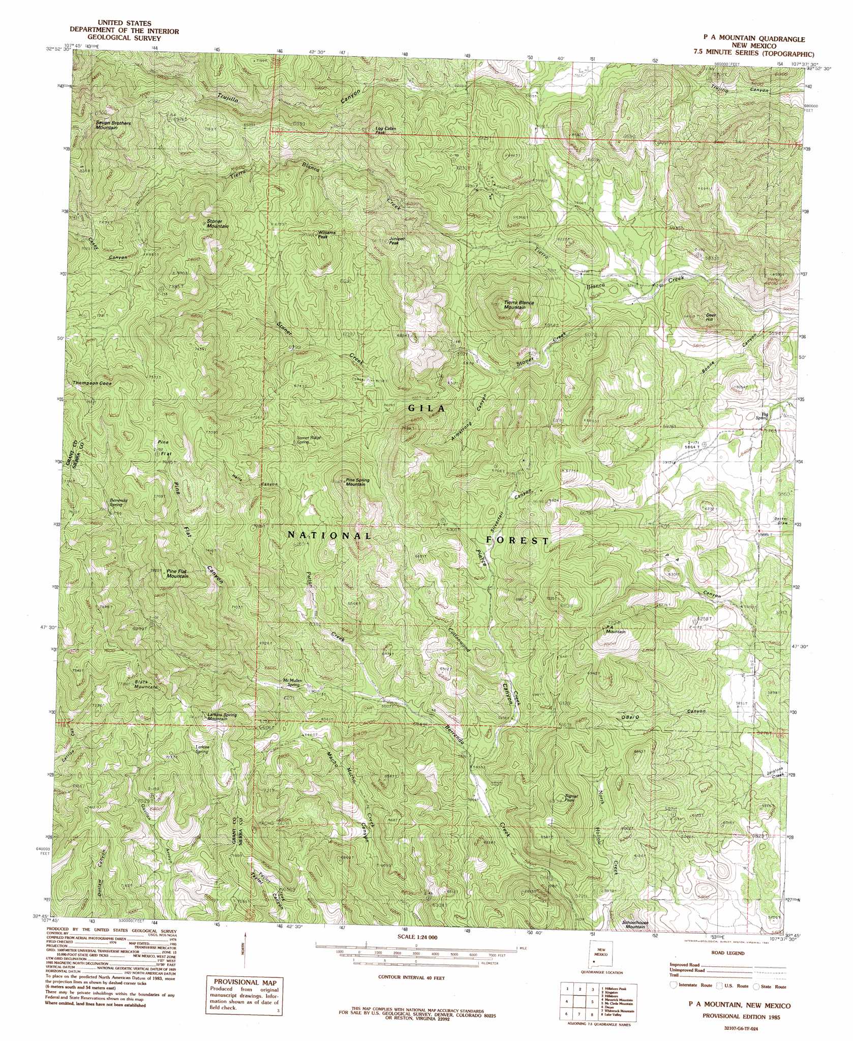
Pa Mountain Topo Map New Mexico
To zoom in, hover over the map of Pa Mountain
USGS Topo Quad 32107g6 - 1:24,000 scale
| Topo Map Name: | Pa Mountain |
| USGS Topo Quad ID: | 32107g6 |
| Print Size: | ca. 21 1/4" wide x 27" high |
| Southeast Coordinates: | 32.75° N latitude / 107.625° W longitude |
| Map Center Coordinates: | 32.8125° N latitude / 107.6875° W longitude |
| U.S. State: | NM |
| Filename: | o32107g6.jpg |
| Download Map JPG Image: | Pa Mountain topo map 1:24,000 scale |
| Map Type: | Topographic |
| Topo Series: | 7.5´ |
| Map Scale: | 1:24,000 |
| Source of Map Images: | United States Geological Survey (USGS) |
| Alternate Map Versions: |
P A Mountain NM 1985, updated 1985 Download PDF Buy paper map P A Mountain NM 1999, updated 2002 Download PDF Buy paper map P A Mountain NM 2011 Download PDF Buy paper map P A Mountain NM 2013 Download PDF Buy paper map P A Mountain NM 2017 Download PDF Buy paper map |
| FStopo: | US Forest Service topo P A Mountain is available: Download FStopo PDF Download FStopo TIF |
1:24,000 Topo Quads surrounding Pa Mountain
Hay Mesa |
Victoria Park |
Apache Peak |
Bell Mountain |
Saladone Tank |
Hendricks Peak |
Hillsboro Peak |
Kingston |
Hillsboro |
Skute Stone Arroyo |
San Lorenzo |
Maverick Mountain |
Pa Mountain |
Mcclede Mountain |
Clark Spring Canyon |
Whitehorse Mountain |
Dwyer |
Whiterock Mountain |
Lake Valley |
Jug Canyon |
Taylor Mountain |
Faywood Se |
Ok Canyon |
Greg Hills |
Nutt |
> Back to 32107e1 at 1:100,000 scale
> Back to 32106a1 at 1:250,000 scale
> Back to U.S. Topo Maps home
Pa Mountain topo map: Gazetteer
Pa Mountain: Flats
Pine Flat elevation 2264m 7427′Pa Mountain: Mines
Beardog Mine elevation 2187m 7175′Big Japanese Mine elevation 2519m 8264′
Blue Bell Number Two elevation 1775m 5823′
Hornet Group elevation 1842m 6043′
Japanese Mine elevation 2536m 8320′
Jayhawk Group elevation 1777m 5830′
Latham Iron Mine elevation 1866m 6122′
Log Cabin elevation 2099m 6886′
Lookout elevation 2082m 6830′
Silver Tail elevation 1972m 6469′
Silver Top elevation 1813m 5948′
Silvertail Mine elevation 1989m 6525′
Silvertail Mine elevation 1985m 6512′
Standard Metal Mine elevation 2060m 6758′
Toggery Mine elevation 1829m 6000′
Pa Mountain: Ranges
Mimbres Mountains elevation 2328m 7637′Pa Mountain: Reservoirs
Ant Tank elevation 1986m 6515′Jalarosa Tank elevation 1925m 6315′
Lathum Tank elevation 1867m 6125′
Pa Tank Number One elevation 2033m 6669′
Pa Tank Number Two elevation 1956m 6417′
Silver Tail Tank elevation 1952m 6404′
White Tank elevation 1989m 6525′
Pa Mountain: Springs
Berrenda Spring elevation 2200m 7217′Big Spring elevation 1753m 5751′
Larkins Spring elevation 2100m 6889′
McMullen Spring elevation 1888m 6194′
Stoner Ridge Spring elevation 1970m 6463′
Pa Mountain: Streams
Cottonwood Creek elevation 1803m 5915′Patton Creek elevation 1839m 6033′
Stoner Creek elevation 1743m 5718′
Pa Mountain: Summits
Black Mountain elevation 2301m 7549′Deer Hill elevation 1953m 6407′
Juniper Peak elevation 2200m 7217′
Larkins Spring Mountain elevation 2270m 7447′
Log Cabin Peak elevation 2188m 7178′
P A Mountain elevation 2194m 7198′
Pine Flat Mountain elevation 2385m 7824′
Pine Spring Mountain elevation 2179m 7148′
Schoolhouse Mountain elevation 1895m 6217′
Signal Peak elevation 2075m 6807′
Stoner Mountain elevation 2362m 7749′
Thompson Cone elevation 2396m 7860′
Tierra Blanca Mountain elevation 2155m 7070′
Williams Peak elevation 2132m 6994′
Pa Mountain: Valleys
Armstrong Canyon elevation 1789m 5869′Boone Canyon elevation 1696m 5564′
Casey Canyon elevation 2144m 7034′
Hells Canyon elevation 1953m 6407′
Pierce Canyon elevation 1795m 5889′
Pine Flat Canyon elevation 1914m 6279′
Silvertail Canyon elevation 1902m 6240′
Pa Mountain: Wells
Lockwood Well elevation 1882m 6174′Uncle Lewis Well elevation 1888m 6194′
Pa Mountain digital topo map on disk
Buy this Pa Mountain topo map showing relief, roads, GPS coordinates and other geographical features, as a high-resolution digital map file on DVD: