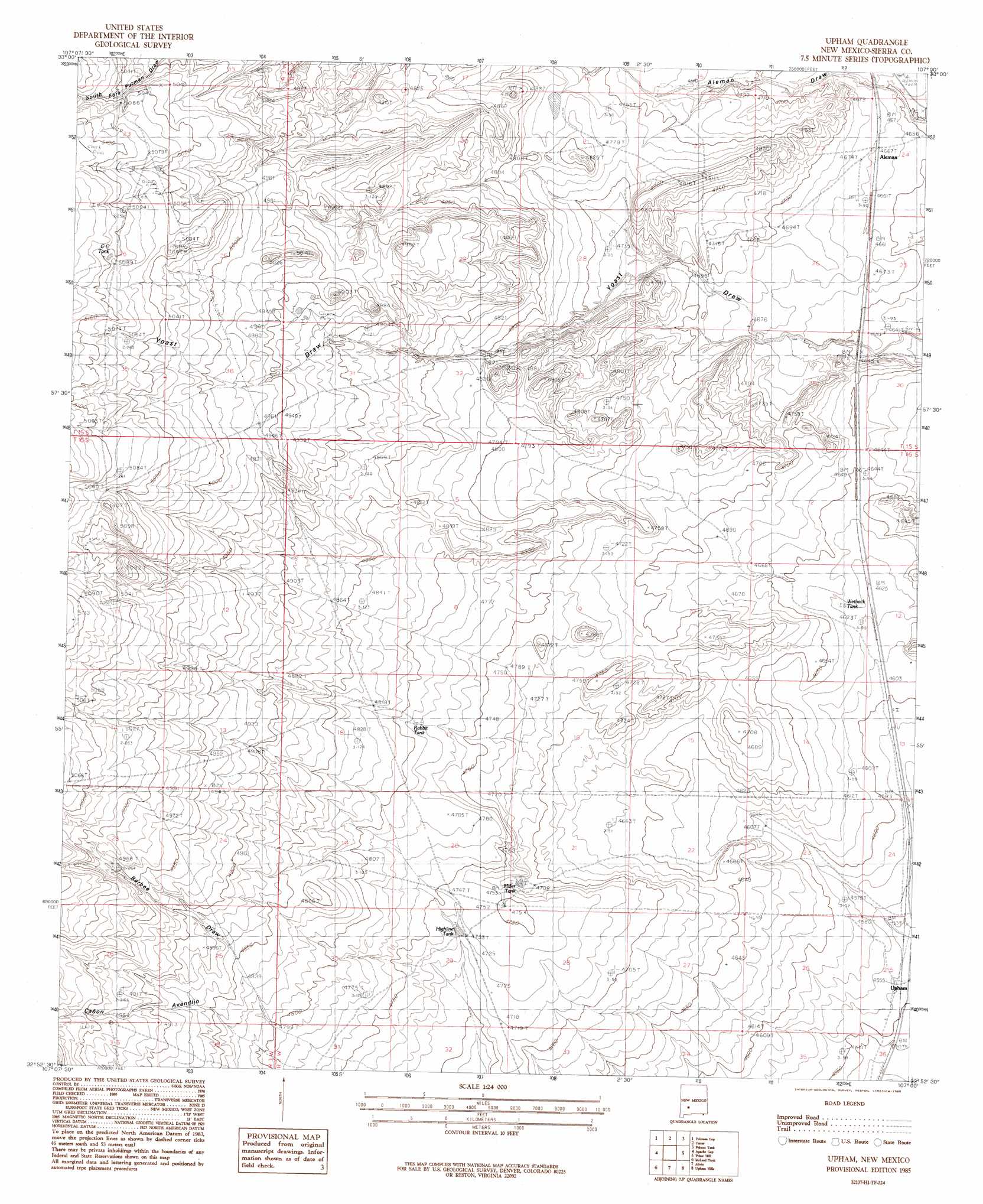
Upham Topo Map New Mexico
To zoom in, hover over the map of Upham
USGS Topo Quad 32107h1 - 1:24,000 scale
| Topo Map Name: | Upham |
| USGS Topo Quad ID: | 32107h1 |
| Print Size: | ca. 21 1/4" wide x 27" high |
| Southeast Coordinates: | 32.875° N latitude / 107° W longitude |
| Map Center Coordinates: | 32.9375° N latitude / 107.0625° W longitude |
| U.S. State: | NM |
| Filename: | o32107h1.jpg |
| Download Map JPG Image: | Upham topo map 1:24,000 scale |
| Map Type: | Topographic |
| Topo Series: | 7.5´ |
| Map Scale: | 1:24,000 |
| Source of Map Images: | United States Geological Survey (USGS) |
| Alternate Map Versions: |
Upham NM 1985, updated 1985 Download PDF Buy paper map Upham NM 1996, updated 2001 Download PDF Buy paper map Upham NM 2010 Download PDF Buy paper map Upham NM 2013 Download PDF Buy paper map Upham NM 2017 Download PDF Buy paper map |
1:24,000 Topo Quads surrounding Upham
Cuchillo |
Elephant Butte |
Engle |
Shannon Canyon Nw |
Shannon Canyon |
Williamsburg |
Palomas Gap |
Cutter |
Polecat Tank |
Dugout Canyon |
Caballo |
Apache Gap |
Upham |
Prisor Hill |
Prisor Well |
Garfield |
Mcleod Tank |
Alivio |
Upham Hills |
Gilmore Draw |
Arroyo Cuervo |
Hatch |
Rincon |
Thorn Well |
Seldon Canyon Ne |
> Back to 32107e1 at 1:100,000 scale
> Back to 32106a1 at 1:250,000 scale
> Back to U.S. Topo Maps home
Upham topo map: Gazetteer
Upham: Dams
Jornada Number Three Dam elevation 1440m 4724′Upham: Levees
Jornada Dikes elevation 1506m 4940′Upham: Mines
Federal M Number One elevation 1437m 4714′Upham: Populated Places
Upham elevation 1390m 4560′Upham: Post Offices
Aleman Post Office (historical) elevation 1423m 4668′Upham: Reservoirs
C C Tank elevation 1556m 5104′Highline Tank elevation 1442m 4730′
Miller Tank elevation 1437m 4714′
Rabbit Tank elevation 1459m 4786′
Wetback Tank elevation 1411m 4629′
Upham: Springs
Sun Ray Midcontinent New Mexico Federal M Number 1 Spring elevation 1433m 4701′Upham: Wells
Foraker Well elevation 1433m 4701′Upham digital topo map on disk
Buy this Upham topo map showing relief, roads, GPS coordinates and other geographical features, as a high-resolution digital map file on DVD: