Kingston Topo Map New Mexico
To zoom in, hover over the map of Kingston
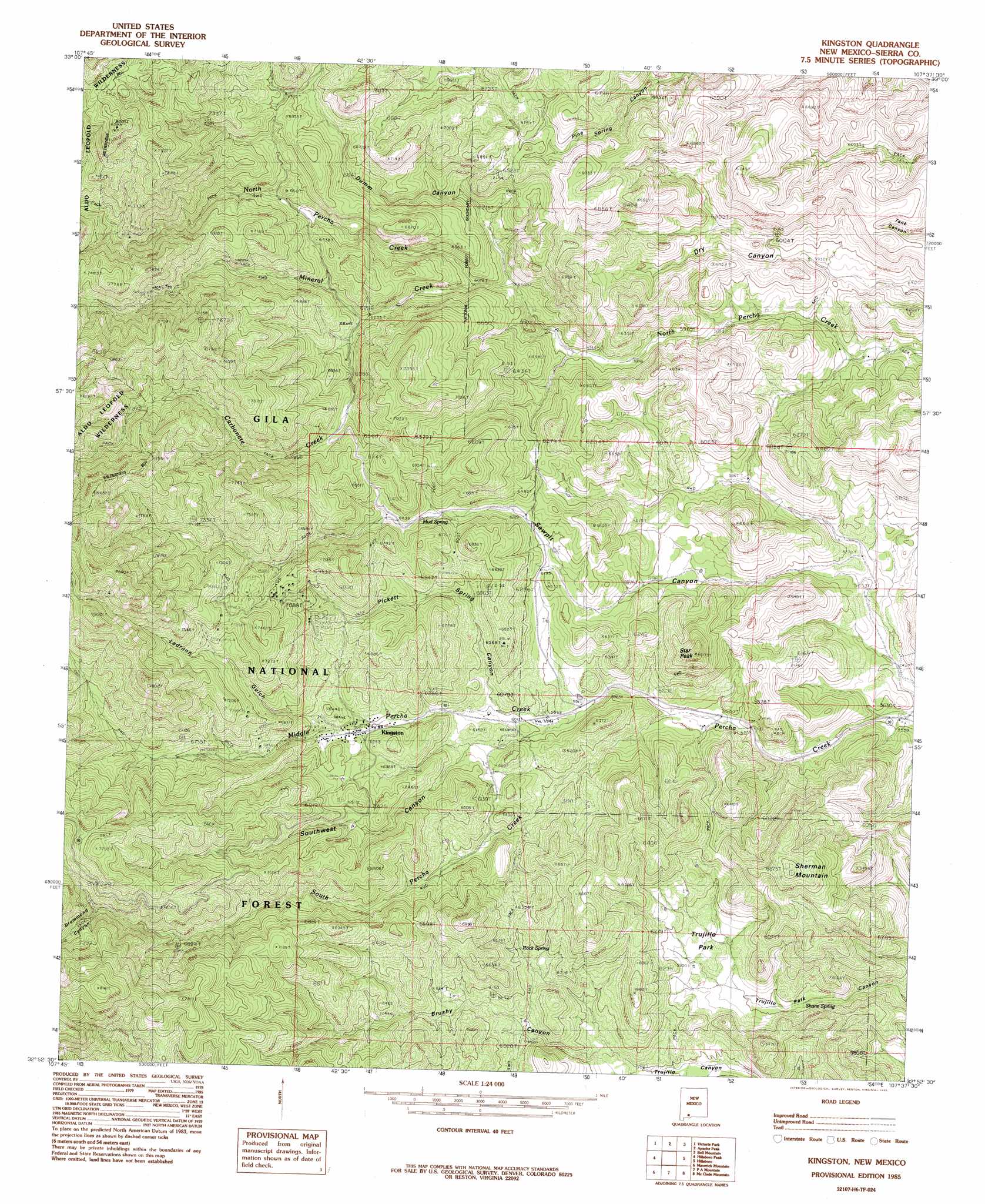
USGS Topo Quad 32107h6 - 1:24,000 scale
| Topo Map Name: | Kingston |
| USGS Topo Quad ID: | 32107h6 |
| Print Size: | ca. 21 1/4" wide x 27" high |
| Southeast Coordinates: | 32.875° N latitude / 107.625° W longitude |
| Map Center Coordinates: | 32.9375° N latitude / 107.6875° W longitude |
| U.S. State: | NM |
| Filename: | o32107h6.jpg |
| Download Map JPG Image: | Kingston topo map 1:24,000 scale |
| Map Type: | Topographic |
| Topo Series: | 7.5´ |
| Map Scale: | 1:24,000 |
| Source of Map Images: | United States Geological Survey (USGS) |
| Alternate Map Versions: |
Kingston NM 1985, updated 1985 Download PDF Buy paper map Kingston NM 1999, updated 2002 Download PDF Buy paper map Kingston NM 2011 Download PDF Buy paper map Kingston NM 2013 Download PDF Buy paper map Kingston NM 2017 Download PDF Buy paper map |
| FStopo: | US Forest Service topo Kingston is available: Download FStopo PDF Download FStopo TIF |
1:24,000 Topo Quads surrounding Kingston
Bonner Canyon |
Reeds Peak |
Sugarloaf Peak |
Thumb Tank Peak |
Williamsburg Nw |
Hay Mesa |
Victoria Park |
Apache Peak |
Bell Mountain |
Saladone Tank |
Hendricks Peak |
Hillsboro Peak |
Kingston |
Hillsboro |
Skute Stone Arroyo |
San Lorenzo |
Maverick Mountain |
Pa Mountain |
Mcclede Mountain |
Clark Spring Canyon |
Whitehorse Mountain |
Dwyer |
Whiterock Mountain |
Lake Valley |
Jug Canyon |
> Back to 32107e1 at 1:100,000 scale
> Back to 32106a1 at 1:250,000 scale
> Back to U.S. Topo Maps home
Kingston topo map: Gazetteer
Kingston: Flats
Trujillo Park elevation 1812m 5944′Kingston: Mines
Andy Johnson and Brush Heap Mine elevation 2123m 6965′Andy Johnson Mine elevation 1997m 6551′
Barite Hill Number 1 elevation 2071m 6794′
Black Colt Claim - North Kingston elevation 2098m 6883′
Black Colt Mine elevation 2132m 6994′
Black Magic Mine elevation 2126m 6975′
Black Sheep Group Mine elevation 2208m 7244′
Black Sheep-North Kingston D Mine elevation 2098m 6883′
Blackeyed Susan Mine elevation 1997m 6551′
Blackie Number 1 Mine elevation 2208m 7244′
Blackie Number One Mine elevation 2098m 6883′
Bloodgood A and B Group elevation 1914m 6279′
Bloodgood Mine elevation 1905m 6250′
Brush Heap Mine elevation 1997m 6551′
Calamity Jane Mine elevation 1997m 6551′
Caledonia Mine elevation 2132m 6994′
Climax Mine elevation 2132m 6994′
Comstock Claim elevation 2098m 6883′
Comstock Mine elevation 2132m 6994′
Cruise Shaft elevation 2031m 6663′
Dove Mine elevation 2036m 6679′
Enterprise Mine elevation 2090m 6856′
Fabian MIne elevation 1972m 6469′
General Jackson Mine elevation 2132m 6994′
Gray Eagle elevation 2124m 6968′
Gray Eagle Mine elevation 2129m 6984′
Gypsy IV Group elevation 2002m 6568′
Gypsy Mine elevation 2132m 6994′
Illinois Mine elevation 1997m 6551′
Iron King Mine elevation 2208m 7244′
Iron King Mine elevation 2132m 6994′
Kangaroo Mine elevation 2132m 6994′
Lady Franklin Mine elevation 2132m 6994′
Matchless Mine elevation 2132m 6994′
Mineral Creek elevation 1993m 6538′
Miners Dream elevation 2208m 7244′
New York Group elevation 2105m 6906′
O K Mine elevation 1909m 6263′
Petaluma elevation 2137m 7011′
Picket Springs Mine elevation 2208m 7244′
Pride of the Camp and Blackeye Mine elevation 1905m 6250′
Sally B Number One Mine elevation 2197m 7208′
Samoa 992-B Mine elevation 1968m 6456′
Silver King Mine elevation 2040m 6692′
Silver Queen elevation 2022m 6633′
So Mine Number One elevation 2057m 6748′
Stowe Mine elevation 2132m 6994′
Superior Mine elevation 2132m 6994′
Superior-North Kingston District elevation 2078m 6817′
Tall Pine Claim-N. Kinston D elevation 2174m 7132′
Tall Pine Mine elevation 2208m 7244′
United States and Illinois elevation 2059m 6755′
United States Mine elevation 1997m 6551′
Victoria Mine elevation 2132m 6994′
Viola Mine elevation 2126m 6975′
Viola Mine elevation 2245m 7365′
Virginia elevation 2056m 6745′
Wagon Wheel and Prospect elevation 2126m 6975′
Wagon Wheel and Prospect Group elevation 2156m 7073′
Yorin-Superior Tunnel elevation 2134m 7001′
Kingston: Populated Places
Kingston elevation 1897m 6223′Kingston: Post Offices
Kingston Post Office (historical) elevation 1897m 6223′Kingston: Reservoirs
Basin Tank elevation 1838m 6030′Boundary Tank elevation 2123m 6965′
Brushy Tank elevation 1837m 6026′
Curleys Tank elevation 1803m 5915′
Lost Tank elevation 1760m 5774′
Rice Tank elevation 1870m 6135′
Sherman Tank elevation 1824m 5984′
Starvation Tank elevation 1843m 6046′
Kingston: Springs
Mud Spring elevation 1964m 6443′Picket Spring elevation 1973m 6473′
Rock Spring elevation 1840m 6036′
Shane Spring elevation 1750m 5741′
Kingston: Streams
Carbonate Creek elevation 1907m 6256′Middle Percha Creek elevation 1767m 5797′
Mineral Creek elevation 1852m 6076′
South Percha Creek elevation 1766m 5793′
Kingston: Summits
Sherman Mountain elevation 2086m 6843′Star Peak elevation 2031m 6663′
Kingston: Valleys
Brushy Canyon elevation 1780m 5839′Drummond Canyon elevation 2145m 7037′
Dumm Canyon elevation 1875m 6151′
Ladron Gulch elevation 1923m 6309′
Pickett Spring Canyon elevation 1851m 6072′
Southwest Canyon elevation 1861m 6105′
Kingston digital topo map on disk
Buy this Kingston topo map showing relief, roads, GPS coordinates and other geographical features, as a high-resolution digital map file on DVD: