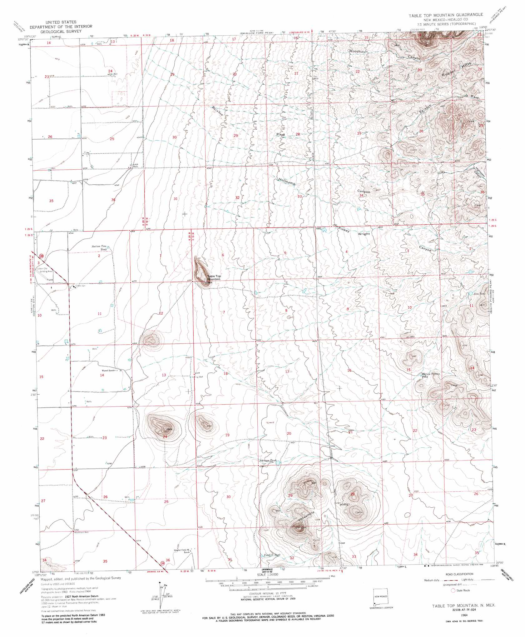
Table Top Mountain Topo Map New Mexico
To zoom in, hover over the map of Table Top Mountain
USGS Topo Quad 32108a7 - 1:24,000 scale
| Topo Map Name: | Table Top Mountain |
| USGS Topo Quad ID: | 32108a7 |
| Print Size: | ca. 21 1/4" wide x 27" high |
| Southeast Coordinates: | 32° N latitude / 108.75° W longitude |
| Map Center Coordinates: | 32.0625° N latitude / 108.8125° W longitude |
| U.S. State: | NM |
| Filename: | o32108a7.jpg |
| Download Map JPG Image: | Table Top Mountain topo map 1:24,000 scale |
| Map Type: | Topographic |
| Topo Series: | 7.5´ |
| Map Scale: | 1:24,000 |
| Source of Map Images: | United States Geological Survey (USGS) |
| Alternate Map Versions: |
Table Top Mountain NM 1964, updated 1966 Download PDF Buy paper map Table Top Mountain NM 1964, updated 1986 Download PDF Buy paper map Table Top Mountain NM 2010 Download PDF Buy paper map Table Top Mountain NM 2013 Download PDF Buy paper map Table Top Mountain NM 2017 Download PDF Buy paper map |
1:24,000 Topo Quads surrounding Table Top Mountain
Doubtful Mountain |
Mondel |
Gary |
Lordsburg |
Lisbon |
Vanar |
Steins |
Swallow Fork Peak |
Pyramid Peak |
Muir Ranch |
San Simon Cienega |
Cotton City |
Table Top Mountain |
South Pyramid Peak |
Coyote Peak |
Portal Ne |
Antelope Pass |
Animas |
Beacon Hill |
Playas Lake North |
Rodeo |
Indian Peak |
Tank Mountain |
Whitmire Pass |
Playas Lake South |
> Back to 32108a1 at 1:100,000 scale
> Back to 32108a1 at 1:250,000 scale
> Back to U.S. Topo Maps home
Table Top Mountain topo map: Gazetteer
Table Top Mountain: Reservoirs
Foothill Tank elevation 1337m 4386′Joes Tank elevation 1433m 4701′
Johnson Tank elevation 1345m 4412′
Section Fifteen Tank elevation 1387m 4550′
Section Two Tank elevation 1299m 4261′
Table Top Mountain: Streams
Rainbow Wash elevation 1287m 4222′Table Top Mountain: Summits
Table Top Mountain elevation 1403m 4603′Threemile Hills elevation 1455m 4773′
Table Top Mountain: Valleys
Hightower Canyon elevation 1458m 4783′Holtkamp Canyon elevation 1296m 4251′
Pinkey Wright Canyon elevation 1338m 4389′
Table Top Mountain: Wells
10067 Water Well elevation 1285m 4215′10070 Water Well elevation 1292m 4238′
10072 Water Well elevation 1298m 4258′
10073 Water Well elevation 1298m 4258′
10113 Water Well elevation 1306m 4284′
10413 Water Well elevation 1302m 4271′
Holmig Well elevation 1323m 4340′
Table Top Mountain digital topo map on disk
Buy this Table Top Mountain topo map showing relief, roads, GPS coordinates and other geographical features, as a high-resolution digital map file on DVD: