Cotton City Topo Map New Mexico
To zoom in, hover over the map of Cotton City
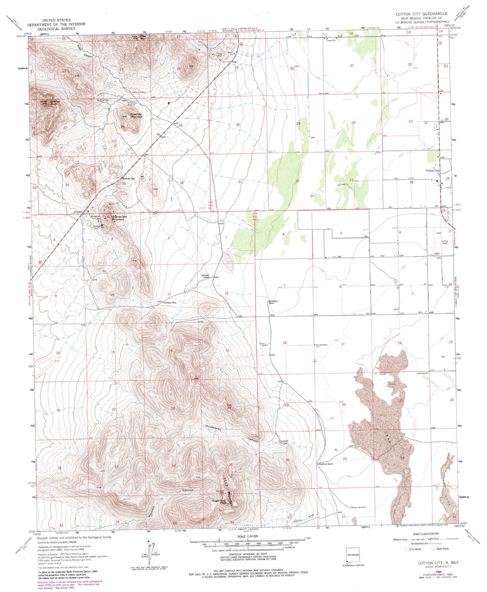
USGS Topo Quad 32108a8 - 1:24,000 scale
| Topo Map Name: | Cotton City |
| USGS Topo Quad ID: | 32108a8 |
| Print Size: | ca. 21 1/4" wide x 27" high |
| Southeast Coordinates: | 32° N latitude / 108.875° W longitude |
| Map Center Coordinates: | 32.0625° N latitude / 108.9375° W longitude |
| U.S. State: | NM |
| Filename: | o32108a8.jpg |
| Download Map JPG Image: | Cotton City topo map 1:24,000 scale |
| Map Type: | Topographic |
| Topo Series: | 7.5´ |
| Map Scale: | 1:24,000 |
| Source of Map Images: | United States Geological Survey (USGS) |
| Alternate Map Versions: |
Cotton City NM 1964, updated 1967 Download PDF Buy paper map Cotton City NM 1964, updated 1980 Download PDF Buy paper map Cotton City NM 2010 Download PDF Buy paper map Cotton City NM 2013 Download PDF Buy paper map Cotton City NM 2017 Download PDF Buy paper map |
1:24,000 Topo Quads surrounding Cotton City
San Simon |
Doubtful Mountain |
Mondel |
Gary |
Lordsburg |
Vanar Nw |
Vanar |
Steins |
Swallow Fork Peak |
Pyramid Peak |
Blue Mountain |
San Simon Cienega |
Cotton City |
Table Top Mountain |
South Pyramid Peak |
Portal |
Portal Ne |
Antelope Pass |
Animas |
Beacon Hill |
Portal Peak |
Rodeo |
Indian Peak |
Tank Mountain |
Whitmire Pass |
> Back to 32108a1 at 1:100,000 scale
> Back to 32108a1 at 1:250,000 scale
> Back to U.S. Topo Maps home
Cotton City topo map: Gazetteer
Cotton City: Gaps
Cowboy Pass elevation 1322m 4337′Granite Gap elevation 1364m 4475′
Cotton City: Mines
Blue Hill Mine elevation 1396m 4580′Crystal Mine elevation 1379m 4524′
Granite Gap Mines elevation 1356m 4448′
Montgomery Mine elevation 1397m 4583′
Scheelite Group elevation 1436m 4711′
Vesley Mine elevation 1329m 4360′
Ward Mine elevation 1457m 4780′
Cotton City: Populated Places
Cotton City elevation 1291m 4235′Cotton City: Summits
1117 Mountain elevation 1757m 5764′Blue Mountain elevation 1751m 5744′
Eagle Nest Peak elevation 1758m 5767′
Granite Gap Mountain elevation 1499m 4917′
Granite Peak elevation 1746m 5728′
One Thousand One Hundred Seventeen Mountain elevation 1757m 5764′
Preacher Mountain elevation 1545m 5068′
Cotton City: Valleys
Martin Draw elevation 1316m 4317′Weatherby Canyon elevation 1304m 4278′
Cotton City: Wells
10082 Water Well elevation 1291m 4235′10096 Water Well elevation 1296m 4251′
10403 Water Well elevation 1287m 4222′
Cotton City digital topo map on disk
Buy this Cotton City topo map showing relief, roads, GPS coordinates and other geographical features, as a high-resolution digital map file on DVD: