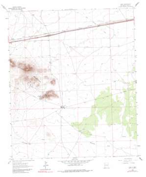
Gage Topo Map New Mexico
To zoom in, hover over the map of Gage
USGS Topo Quad 32108b1 - 1:24,000 scale
| Topo Map Name: | Gage |
| USGS Topo Quad ID: | 32108b1 |
| Print Size: | ca. 21 1/4" wide x 27" high |
| Southeast Coordinates: | 32.125° N latitude / 108° W longitude |
| Map Center Coordinates: | 32.1875° N latitude / 108.0625° W longitude |
| U.S. State: | NM |
| Filename: | o32108b1.jpg |
| Download Map JPG Image: | Gage topo map 1:24,000 scale |
| Map Type: | Topographic |
| Topo Series: | 7.5´ |
| Map Scale: | 1:24,000 |
| Source of Map Images: | United States Geological Survey (USGS) |
| Alternate Map Versions: |
Gage NM 1963, updated 1966 Download PDF Buy paper map Gage NM 1963, updated 1980 Download PDF Buy paper map Gage NM 2010 Download PDF Buy paper map Gage NM 2013 Download PDF Buy paper map Gage NM 2017 Download PDF Buy paper map |
1:24,000 Topo Quads surrounding Gage
> Back to 32108a1 at 1:100,000 scale
> Back to 32108a1 at 1:250,000 scale
> Back to U.S. Topo Maps home
Gage topo map: Gazetteer
Gage: Mines
Burke Mine elevation 1434m 4704′Chance and Jessie Mines elevation 1409m 4622′
Excess Mine elevation 1348m 4422′
Helen elevation 1343m 4406′
Irish Rose elevation 1389m 4557′
Jessie Mine elevation 1405m 4609′
Parole Mine elevation 1359m 4458′
Rambler Mine elevation 1349m 4425′
Rover Group elevation 1334m 4376′
Tedford Prospect elevation 1390m 4560′
Victorio Group elevation 1387m 4550′
Gage: Populated Places
Gage elevation 1369m 4491′Gage: Post Offices
Gage Post Office (historical) elevation 1369m 4491′Gage: Ranges
Victorio Mountains elevation 1631m 5351′Gage: Reservoirs
CCC Tank elevation 1314m 4311′Gage: Streams
Walnut Creek elevation 1348m 4422′Gage: Valleys
Cow Springs Draw elevation 1347m 4419′Gage: Wells
00626 Water Well elevation 1333m 4373′00627 Water Well elevation 1331m 4366′
00628 Water Well elevation 1333m 4373′
00629 Water Well elevation 1334m 4376′
00631 Water Well elevation 1330m 4363′
01390 Water Well elevation 1369m 4491′
01391 Water Well elevation 1375m 4511′
01392 Water Well elevation 1357m 4452′
01393 Water Well elevation 1347m 4419′
01394 Water Well elevation 1346m 4416′
01395 Water Well elevation 1334m 4376′
01396 Water Well elevation 1333m 4373′
01421 Water Well elevation 1334m 4376′
01422 Water Well elevation 1329m 4360′
01423 Water Well elevation 1325m 4347′
01424 Water Well elevation 1324m 4343′
10228 Water Well elevation 1351m 4432′
10229 Water Well elevation 1351m 4432′
10248 Water Well elevation 1332m 4370′
1389 Water Well elevation 1376m 4514′
1569 Water Well elevation 1382m 4534′
1574 Water Well elevation 1372m 4501′
Antelope Wells elevation 1330m 4363′
Berts Well elevation 1347m 4419′
M-2279 Water Well elevation 1341m 4399′
Gage digital topo map on disk
Buy this Gage topo map showing relief, roads, GPS coordinates and other geographical features, as a high-resolution digital map file on DVD:


