Steins Topo Map New Mexico
To zoom in, hover over the map of Steins
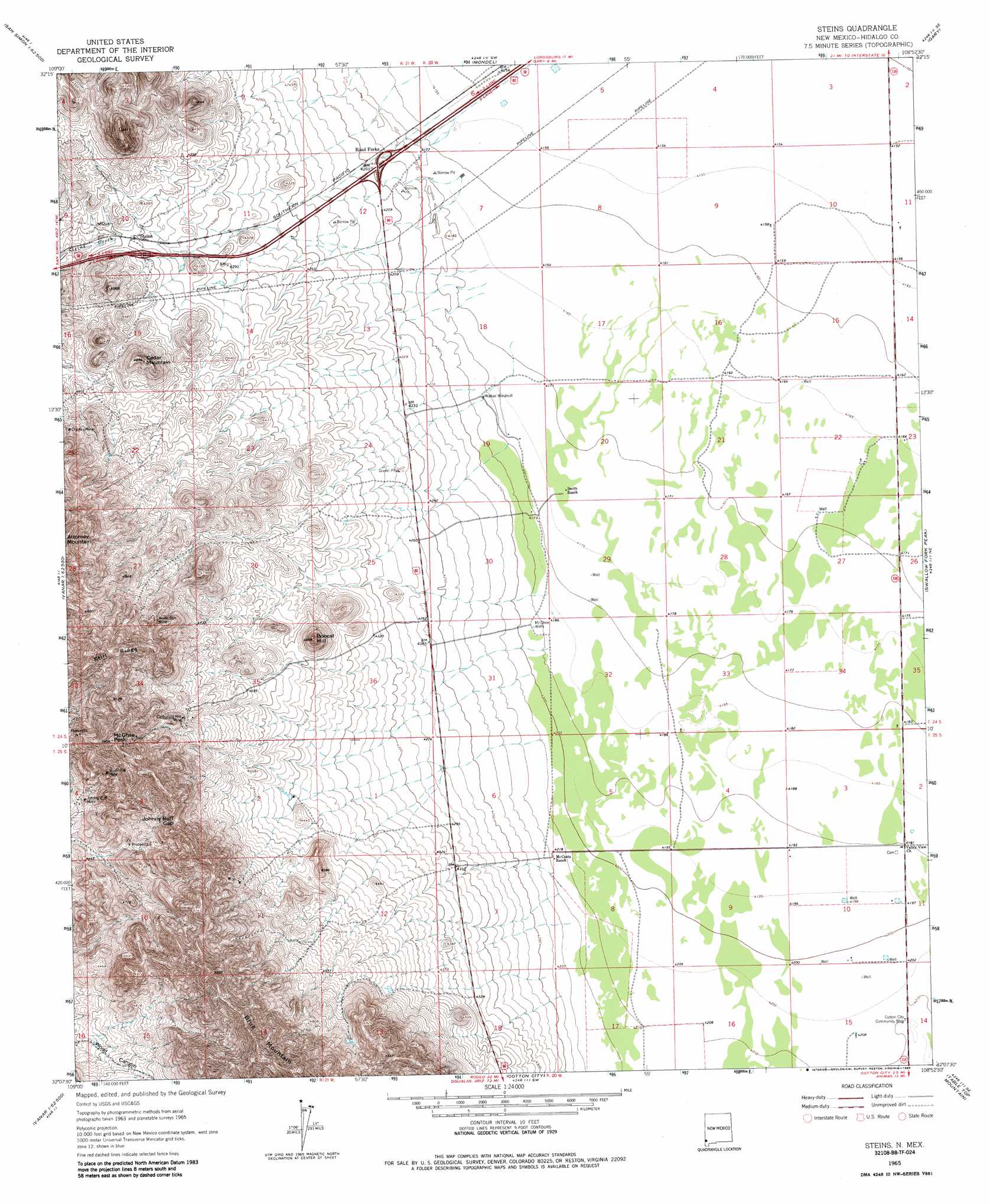
USGS Topo Quad 32108b8 - 1:24,000 scale
| Topo Map Name: | Steins |
| USGS Topo Quad ID: | 32108b8 |
| Print Size: | ca. 21 1/4" wide x 27" high |
| Southeast Coordinates: | 32.125° N latitude / 108.875° W longitude |
| Map Center Coordinates: | 32.1875° N latitude / 108.9375° W longitude |
| U.S. State: | NM |
| Filename: | o32108b8.jpg |
| Download Map JPG Image: | Steins topo map 1:24,000 scale |
| Map Type: | Topographic |
| Topo Series: | 7.5´ |
| Map Scale: | 1:24,000 |
| Source of Map Images: | United States Geological Survey (USGS) |
| Alternate Map Versions: |
Steins NM 1965, updated 1966 Download PDF Buy paper map Steins NM 1965, updated 1984 Download PDF Buy paper map Steins NM 2010 Download PDF Buy paper map Steins NM 2013 Download PDF Buy paper map Steins NM 2017 Download PDF Buy paper map |
1:24,000 Topo Quads surrounding Steins
Orange Butte |
Engine Mountain |
Summit |
Ninemile Hill |
Culberson Ranch |
San Simon |
Doubtful Mountain |
Mondel |
Gary |
Lordsburg |
Vanar Nw |
Vanar |
Steins |
Swallow Fork Peak |
Pyramid Peak |
Blue Mountain |
San Simon Cienega |
Cotton City |
Table Top Mountain |
South Pyramid Peak |
Portal |
Portal Ne |
Antelope Pass |
Animas |
Beacon Hill |
> Back to 32108a1 at 1:100,000 scale
> Back to 32108a1 at 1:250,000 scale
> Back to U.S. Topo Maps home
Steins topo map: Gazetteer
Steins: Bridges
Cotton City Community Bridge elevation 1284m 4212′Steins: Gaps
Johnny Bull Gap elevation 1463m 4799′Steins: Mines
Carbonate Hill Mine elevation 1425m 4675′Charles Mine elevation 1382m 4534′
Johnny Bull Mine elevation 1373m 4504′
New Year Prospect elevation 1464m 4803′
North Star Mine elevation 1441m 4727′
Silver Hill Mine elevation 1463m 4799′
Steins: Populated Places
McGhee Wells elevation 1279m 4196′Steins elevation 1325m 4347′
Steins: Post Offices
Steins Post Office (historical) elevation 1325m 4347′Steins: Ridges
Still Ridge elevation 1591m 5219′Steins: Summits
Bobcat Hill elevation 1415m 4642′Cedar Mountain elevation 1414m 4639′
McGhee Peak elevation 1643m 5390′
Steins: Wells
10042 Water Well elevation 1274m 4179′Steins digital topo map on disk
Buy this Steins topo map showing relief, roads, GPS coordinates and other geographical features, as a high-resolution digital map file on DVD: