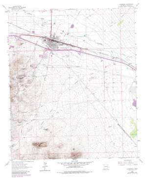
Lordsburg Topo Map New Mexico
To zoom in, hover over the map of Lordsburg
USGS Topo Quad 32108c6 - 1:24,000 scale
| Topo Map Name: | Lordsburg |
| USGS Topo Quad ID: | 32108c6 |
| Print Size: | ca. 21 1/4" wide x 27" high |
| Southeast Coordinates: | 32.25° N latitude / 108.625° W longitude |
| Map Center Coordinates: | 32.3125° N latitude / 108.6875° W longitude |
| U.S. State: | NM |
| Filename: | o32108c6.jpg |
| Download Map JPG Image: | Lordsburg topo map 1:24,000 scale |
| Map Type: | Topographic |
| Topo Series: | 7.5´ |
| Map Scale: | 1:24,000 |
| Source of Map Images: | United States Geological Survey (USGS) |
| Alternate Map Versions: |
Lordsburg NM 1963, updated 1965 Download PDF Buy paper map Lordsburg NM 1963, updated 1980 Download PDF Buy paper map Lordsburg NM 1963, updated 1980 Download PDF Buy paper map Lordsburg NM 2010 Download PDF Buy paper map Lordsburg NM 2013 Download PDF Buy paper map Lordsburg NM 2017 Download PDF Buy paper map |
1:24,000 Topo Quads surrounding Lordsburg
> Back to 32108a1 at 1:100,000 scale
> Back to 32108a1 at 1:250,000 scale
> Back to U.S. Topo Maps home
Lordsburg topo map: Gazetteer
Lordsburg: Airports
Lordsburg Municipal Airport elevation 1304m 4278′Lordsburg: Mines
Atwood Mine elevation 1411m 4629′Bessie elevation 1384m 4540′
Bluebird Mine elevation 1381m 4530′
Bluebird Mine elevation 1394m 4573′
Copper Reef Group Mine elevation 1412m 4632′
Cornelia I and Emma I Mine elevation 1412m 4632′
Dewey Lode elevation 1407m 4616′
Dry Town Lode elevation 1403m 4603′
Florence Lode elevation 1382m 4534′
General Jerry Boyle elevation 1407m 4616′
Green Copper elevation 1463m 4799′
Henry Clay Mine elevation 1389m 4557′
Judita Group elevation 1351m 4432′
Kingfisher elevation 1342m 4402′
Lady Mary elevation 1408m 4619′
Lady Mary Mine elevation 1417m 4648′
Lone Star Prospect elevation 1417m 4648′
Metropolis Group elevation 1382m 4534′
Monrovia Lode elevation 1391m 4563′
Napoleon and Belle Tower Lode elevation 1394m 4573′
Nevada Lode elevation 1406m 4612′
Oakland Lode elevation 1418m 4652′
Rosemary Lode elevation 1358m 4455′
Ruth elevation 1406m 4612′
Ruth Mine elevation 1415m 4642′
Southern Lode elevation 1370m 4494′
Triangle Lode elevation 1379m 4524′
Valedon Mine elevation 1381m 4530′
Waldo Mine elevation 1361m 4465′
Yellow Jacket elevation 1366m 4481′
Lordsburg: Parks
Lordsburg Historical Marker elevation 1295m 4248′Shakespeare Historical Marker elevation 1362m 4468′
Short Park elevation 1300m 4265′
Lordsburg: Populated Places
Lordsburg elevation 1295m 4248′Shakespeare elevation 1362m 4468′
Ulmoris elevation 1283m 4209′
Valedon elevation 1386m 4547′
Lordsburg: Post Offices
Lordsburg Post Office elevation 1295m 4248′Valedon Post Office (historical) elevation 1386m 4547′
Lordsburg: Streams
Shakespeare Arroyo elevation 1275m 4183′Lordsburg: Summits
Atwood Hill elevation 1419m 4655′Buggytop Hill elevation 1407m 4616′
Wildcat Hill elevation 1347m 4419′
Lordsburg: Valleys
Aberdeen Draw elevation 1341m 4399′Bluebird Draw elevation 1361m 4465′
Engineer Canyon elevation 1281m 4202′
Gold Hill Canyon elevation 1278m 4192′
Mudhole Draw elevation 1280m 4199′
Lordsburg: Wells
10006 Water Well elevation 1293m 4242′10007 Water Well elevation 1287m 4222′
Lordsburg digital topo map on disk
Buy this Lordsburg topo map showing relief, roads, GPS coordinates and other geographical features, as a high-resolution digital map file on DVD:


