Gary Topo Map New Mexico
To zoom in, hover over the map of Gary
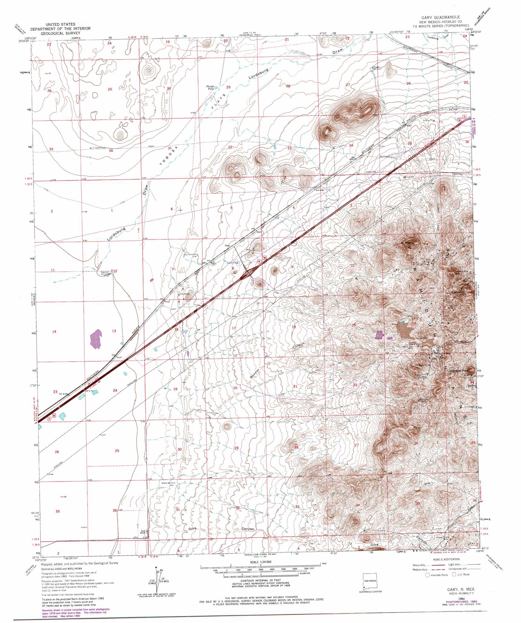
USGS Topo Quad 32108c7 - 1:24,000 scale
| Topo Map Name: | Gary |
| USGS Topo Quad ID: | 32108c7 |
| Print Size: | ca. 21 1/4" wide x 27" high |
| Southeast Coordinates: | 32.25° N latitude / 108.75° W longitude |
| Map Center Coordinates: | 32.3125° N latitude / 108.8125° W longitude |
| U.S. State: | NM |
| Filename: | o32108c7.jpg |
| Download Map JPG Image: | Gary topo map 1:24,000 scale |
| Map Type: | Topographic |
| Topo Series: | 7.5´ |
| Map Scale: | 1:24,000 |
| Source of Map Images: | United States Geological Survey (USGS) |
| Alternate Map Versions: |
Gary NM 1964, updated 1966 Download PDF Buy paper map Gary NM 1964, updated 1980 Download PDF Buy paper map Gary NM 2010 Download PDF Buy paper map Gary NM 2013 Download PDF Buy paper map Gary NM 2017 Download PDF Buy paper map |
1:24,000 Topo Quads surrounding Gary
Round Mountain |
Rock Tank Draw |
Caprock Mountain |
Willow Draw |
Eagle Eye Peak |
Engine Mountain |
Summit |
Ninemile Hill |
Culberson Ranch |
Gold Hill |
Doubtful Mountain |
Mondel |
Gary |
Lordsburg |
Lisbon |
Vanar |
Steins |
Swallow Fork Peak |
Pyramid Peak |
Muir Ranch |
San Simon Cienega |
Cotton City |
Table Top Mountain |
South Pyramid Peak |
Coyote Peak |
> Back to 32108a1 at 1:100,000 scale
> Back to 32108a1 at 1:250,000 scale
> Back to U.S. Topo Maps home
Gary topo map: Gazetteer
Gary: Flats
South Alkali Flat elevation 1266m 4153′Tobosa Flats elevation 1268m 4160′
Gary: Mines
Anita elevation 1419m 4655′Anita Mine elevation 1415m 4642′
August elevation 1414m 4639′
August Number Two elevation 1443m 4734′
Banner Mine elevation 1434m 4704′
Battleship elevation 1412m 4632′
Beloit elevation 1450m 4757′
Bisbee Lode elevation 1465m 4806′
Bonnie Jean elevation 1398m 4586′
Carbonate Hill Mine elevation 1428m 4685′
Cobra Negra elevation 1413m 4635′
Copper Nugget Number 3 and 4 Mine elevation 1418m 4652′
Duchess Lode elevation 1469m 4819′
Excelsior Lode elevation 1490m 4888′
Federal Resources Corporation Mine elevation 1485m 4872′
Flourite Group Mine elevation 1489m 4885′
Francis Kay elevation 1461m 4793′
Francis Kay Mine elevation 1459m 4786′
Gamco Mine elevation 1430m 4691′
Goodnight Lode elevation 1457m 4780′
Goodsight elevation 1417m 4648′
Hobson Mine elevation 1429m 4688′
Homestake Mine elevation 1429m 4688′
Hope Faith and Charity Group Mine elevation 1409m 4622′
Jim Crow Mine elevation 1459m 4786′
Jim Crow Shaft elevation 1459m 4786′
Johannesburg Lode elevation 1396m 4580′
Johnson Lode elevation 1424m 4671′
Lead King elevation 1312m 4304′
Mikesell Group elevation 1411m 4629′
Misers Chest Mine elevation 1443m 4734′
Monteray Lode elevation 1420m 4658′
Nellie Bly Mine elevation 1406m 4612′
Nellie Gray Mine elevation 1406m 4612′
Ophir Mining Claim elevation 1409m 4622′
Oro Alta elevation 1449m 4753′
Owl elevation 1430m 4691′
Owl Mine elevation 1441m 4727′
Polyanna Mine elevation 1445m 4740′
Princess Lode elevation 1490m 4888′
Robert E Lee Mine elevation 1384m 4540′
Ronney-Misers Chest and 85 Mine elevation 1425m 4675′
Royal Lode elevation 1489m 4885′
Schley elevation 1408m 4619′
Search Lode elevation 1442m 4730′
Summit Group elevation 1471m 4826′
Venice elevation 1449m 4753′
Wedge elevation 1485m 4872′
Winchester Lode elevation 1428m 4685′
Gary: Populated Places
Gary elevation 1290m 4232′Gary: Reservoirs
Slough Tank elevation 1269m 4163′Gary: Summits
Aberdeen Peak elevation 1536m 5039′Eightyfive Hill elevation 1552m 5091′
Lee Peak elevation 1504m 4934′
Lookout Hill elevation 1513m 4963′
Gary: Valleys
Banner Canyon elevation 1269m 4163′Gore Canyon elevation 1268m 4160′
Lordsburg Draw elevation 1266m 4153′
Gary: Wells
10009 Water Well elevation 1266m 4153′Gary digital topo map on disk
Buy this Gary topo map showing relief, roads, GPS coordinates and other geographical features, as a high-resolution digital map file on DVD: