Burro Peak Topo Map New Mexico
To zoom in, hover over the map of Burro Peak
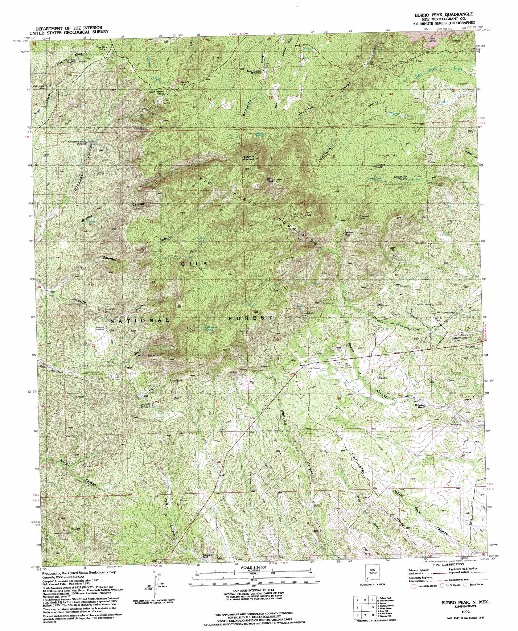
USGS Topo Quad 32108e4 - 1:24,000 scale
| Topo Map Name: | Burro Peak |
| USGS Topo Quad ID: | 32108e4 |
| Print Size: | ca. 21 1/4" wide x 27" high |
| Southeast Coordinates: | 32.5° N latitude / 108.375° W longitude |
| Map Center Coordinates: | 32.5625° N latitude / 108.4375° W longitude |
| U.S. State: | NM |
| Filename: | o32108e4.jpg |
| Download Map JPG Image: | Burro Peak topo map 1:24,000 scale |
| Map Type: | Topographic |
| Topo Series: | 7.5´ |
| Map Scale: | 1:24,000 |
| Source of Map Images: | United States Geological Survey (USGS) |
| Alternate Map Versions: |
Burro Peak NM 1950, updated 1967 Download PDF Buy paper map Big Burro Mountains NM 1951 Download PDF Buy paper map Burro Peak NM 1951 Download PDF Buy paper map Burro Peak NM 1992, updated 1992 Download PDF Buy paper map Burro Peak NM 1999, updated 2002 Download PDF Buy paper map Burro Peak NM 2011 Download PDF Buy paper map Burro Peak NM 2013 Download PDF Buy paper map Burro Peak NM 2017 Download PDF Buy paper map |
| FStopo: | US Forest Service topo Burro Peak is available: Download FStopo PDF Download FStopo TIF |
1:24,000 Topo Quads surrounding Burro Peak
Brushy Mountain |
Mangas Springs |
Circle Mesa |
Silver City |
Fort Bayard |
Redrock |
Bullard Peak |
Wind Mountain |
Tyrone |
Hurley West |
Willow Draw |
Eagle Eye Peak |
Burro Peak |
White Signal |
Whitewater |
Culberson Ranch |
Gold Hill |
C Bar Ranch |
Werney Hill |
Cow Springs Mountain |
Lordsburg |
Lisbon |
Ninetysix Ranch |
Soldiers Farewell Hill |
Grandmother Mountain West |
> Back to 32108e1 at 1:100,000 scale
> Back to 32108a1 at 1:250,000 scale
> Back to U.S. Topo Maps home
Burro Peak topo map: Gazetteer
Burro Peak: Mines
Austin Amazon Mines elevation 2060m 6758′Copeland Mine elevation 2124m 6968′
Deadman Canyon Shafts and Prospect elevation 1971m 6466′
Floyd Collins Mine elevation 1877m 6158′
Gold Gulch Placer elevation 1769m 5803′
Hop Williams Mine elevation 2081m 6827′
John Malone Shaft elevation 1727m 5666′
Merry Widow Mine elevation 1862m 6108′
Merry Widow Shaft elevation 1875m 6151′
Neglected Mine elevation 1984m 6509′
Red Hill Turquoise Mine elevation 2013m 6604′
S Big Burro Mountains Euxenite Deposit elevation 1955m 6414′
Shrine elevation 1966m 6450′
Silver Dollar Mine elevation 2031m 6663′
Silver Dollar Mine elevation 1953m 6407′
Spar Hill Mine elevation 2029m 6656′
Sprouse Mine elevation 2107m 6912′
Summit Deposit elevation 2080m 6824′
Sunset Gold Field elevation 1772m 5813′
Uncle Jimmy Thwaits Mine elevation 2106m 6909′
Wild Irishman Number 5 Shafts elevation 1780m 5839′
Burro Peak: Reservoirs
Copeland Tank elevation 1952m 6404′Knight Canyon Tank elevation 1851m 6072′
Tank Number One elevation 1807m 5928′
Burro Peak: Springs
Gold Gulch Spring elevation 1866m 6122′Grapevine Spring elevation 2031m 6663′
Mud Spring elevation 2205m 7234′
Rustler Spring elevation 1803m 5915′
Burro Peak: Summits
Burro Peak elevation 2445m 8021′Ferguson Mountain elevation 2424m 7952′
Indian Hill elevation 2071m 6794′
Jacks Peak elevation 2428m 7965′
Red Hill elevation 2029m 6656′
Burro Peak: Valleys
Power Line Canyon elevation 1914m 6279′Rustler Canyon elevation 1730m 5675′
Sawmill Canyon elevation 1731m 5679′
Burro Peak: Wells
00988 Water Well elevation 1942m 6371′00989 Water Well elevation 1906m 6253′
Burro Peak digital topo map on disk
Buy this Burro Peak topo map showing relief, roads, GPS coordinates and other geographical features, as a high-resolution digital map file on DVD: