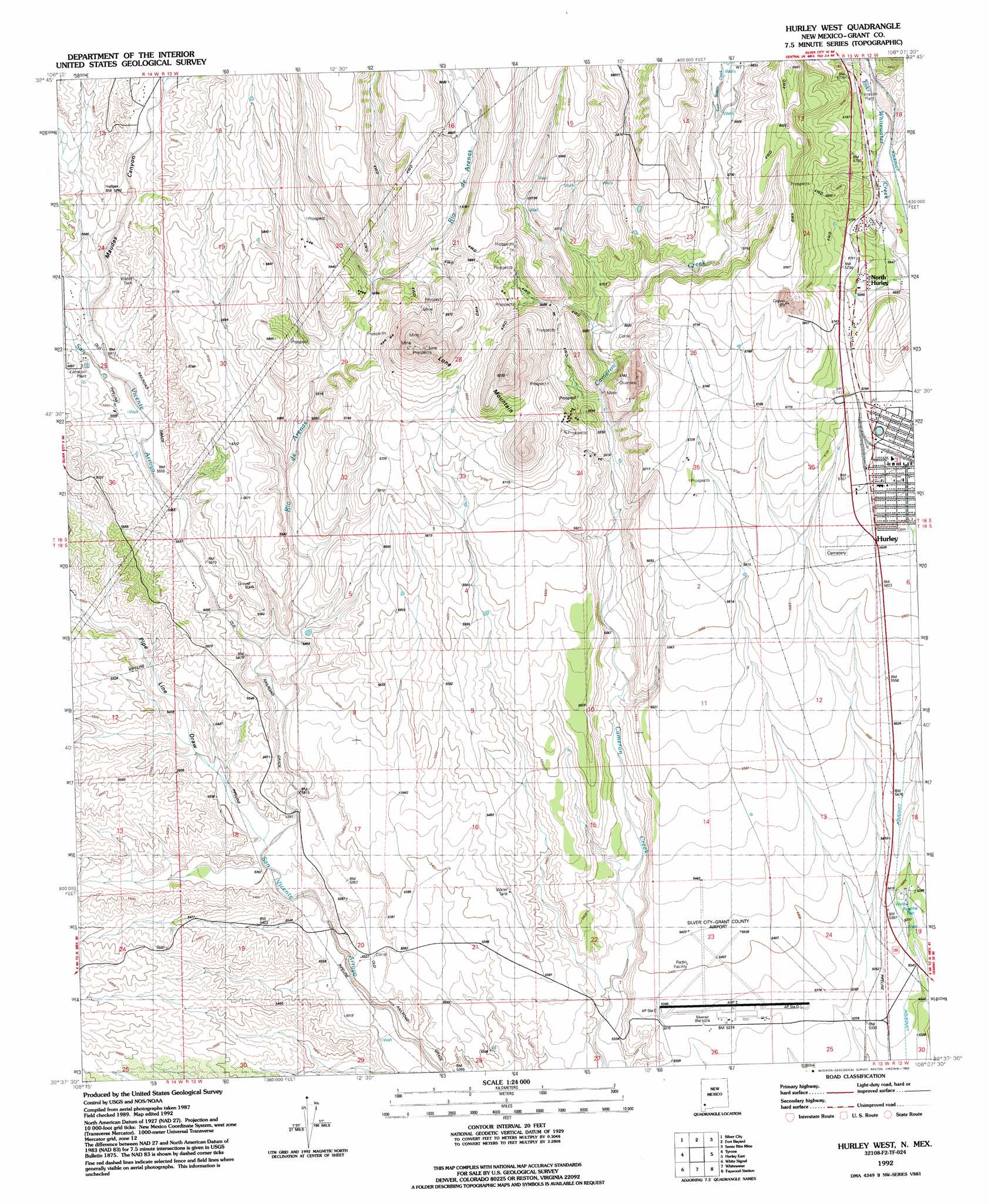
Hurley West Topo Map New Mexico
To zoom in, hover over the map of Hurley West
USGS Topo Quad 32108f2 - 1:24,000 scale
| Topo Map Name: | Hurley West |
| USGS Topo Quad ID: | 32108f2 |
| Print Size: | ca. 21 1/4" wide x 27" high |
| Southeast Coordinates: | 32.625° N latitude / 108.125° W longitude |
| Map Center Coordinates: | 32.6875° N latitude / 108.1875° W longitude |
| U.S. State: | NM |
| Filename: | o32108f2.jpg |
| Download Map JPG Image: | Hurley West topo map 1:24,000 scale |
| Map Type: | Topographic |
| Topo Series: | 7.5´ |
| Map Scale: | 1:24,000 |
| Source of Map Images: | United States Geological Survey (USGS) |
| Alternate Map Versions: |
Hurley West NM 1949, updated 1966 Download PDF Buy paper map Hurley West NM 1949, updated 1970 Download PDF Buy paper map Hurley West NM 1992, updated 1992 Download PDF Buy paper map Hurley West NM 2010 Download PDF Buy paper map Hurley West NM 2013 Download PDF Buy paper map Hurley West NM 2017 Download PDF Buy paper map |
1:24,000 Topo Quads surrounding Hurley West
Dorsey Ranch |
Reading Mountain |
Twin Sisters |
Allie Canyon |
Hendricks Peak |
Circle Mesa |
Silver City |
Fort Bayard |
Santa Rita |
San Lorenzo |
Wind Mountain |
Tyrone |
Hurley West |
Hurley East |
Whitehorse Mountain |
Burro Peak |
White Signal |
Whitewater |
Faywood Station |
Taylor Mountain |
C Bar Ranch |
Werney Hill |
Cow Springs Mountain |
Antelope Hill |
Spalding |
> Back to 32108e1 at 1:100,000 scale
> Back to 32108a1 at 1:250,000 scale
> Back to U.S. Topo Maps home
Hurley West topo map: Gazetteer
Hurley West: Airports
Silver City Airport elevation 1645m 5396′Hurley West: Mines
Ben Hur Mine elevation 1745m 5725′Eighty Four Mine elevation 1735m 5692′
Home Ticket Mine elevation 1735m 5692′
Joe Mine elevation 1772m 5813′
Monarch Mine elevation 1735m 5692′
New York Mine elevation 1735m 5692′
Sweet Home Mine elevation 1772m 5813′
Hurley West: Populated Places
Hurley elevation 1744m 5721′Newton (historical) elevation 1907m 6256′
North Hurley elevation 1737m 5698′
Hurley West: Streams
Rio de Arenas elevation 1653m 5423′Twin Sisters Creek elevation 1765m 5790′
Hurley West: Summits
Lone Mountain elevation 1907m 6256′Hurley West: Valleys
Maudes Canyon elevation 1708m 5603′Pipe Line Draw elevation 1636m 5367′
Hurley West: Wells
00335 Water Well elevation 1740m 5708′00340 Water Well elevation 1743m 5718′
00345 Water Well elevation 1744m 5721′
00407 Water Well elevation 1767m 5797′
00411 Water Well elevation 1736m 5695′
00412 Water Well elevation 1734m 5688′
00414 Water Well elevation 1723m 5652′
00449 Water Well elevation 1752m 5748′
00734 Water Well elevation 1644m 5393′
00736 Water Well elevation 1634m 5360′
00759 Water Well elevation 1683m 5521′
00775 Water Well elevation 1651m 5416′
00791 Water Well elevation 1677m 5501′
10024 Water Well elevation 1775m 5823′
10029 Water Well elevation 1808m 5931′
10030 Water Well elevation 1765m 5790′
Apache Tejo elevation 1643m 5390′
G 773 Water Well elevation 1623m 5324′
G 778 Water Well elevation 1639m 5377′
G 790 Water Well elevation 1683m 5521′
Hurley West digital topo map on disk
Buy this Hurley West topo map showing relief, roads, GPS coordinates and other geographical features, as a high-resolution digital map file on DVD: