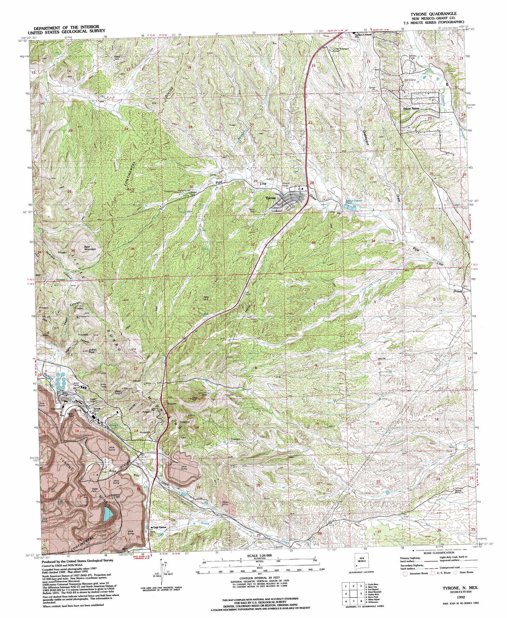
Tyrone Topo Map New Mexico
To zoom in, hover over the map of Tyrone
USGS Topo Quad 32108f3 - 1:24,000 scale
| Topo Map Name: | Tyrone |
| USGS Topo Quad ID: | 32108f3 |
| Print Size: | ca. 21 1/4" wide x 27" high |
| Southeast Coordinates: | 32.625° N latitude / 108.25° W longitude |
| Map Center Coordinates: | 32.6875° N latitude / 108.3125° W longitude |
| U.S. State: | NM |
| Filename: | o32108f3.jpg |
| Download Map JPG Image: | Tyrone topo map 1:24,000 scale |
| Map Type: | Topographic |
| Topo Series: | 7.5´ |
| Map Scale: | 1:24,000 |
| Source of Map Images: | United States Geological Survey (USGS) |
| Alternate Map Versions: |
Tyrone NM 1950, updated 1955 Download PDF Buy paper map Tyrone NM 1951 Download PDF Buy paper map Tyrone NM 1951, updated 1955 Download PDF Buy paper map Tyrone NM 1992, updated 1992 Download PDF Buy paper map Tyrone NM 2010 Download PDF Buy paper map Tyrone NM 2013 Download PDF Buy paper map Tyrone NM 2017 Download PDF Buy paper map |
1:24,000 Topo Quads surrounding Tyrone
Cliff |
Dorsey Ranch |
Reading Mountain |
Twin Sisters |
Allie Canyon |
Mangas Springs |
Circle Mesa |
Silver City |
Fort Bayard |
Santa Rita |
Bullard Peak |
Wind Mountain |
Tyrone |
Hurley West |
Hurley East |
Eagle Eye Peak |
Burro Peak |
White Signal |
Whitewater |
Faywood Station |
Gold Hill |
C Bar Ranch |
Werney Hill |
Cow Springs Mountain |
Antelope Hill |
> Back to 32108e1 at 1:100,000 scale
> Back to 32108a1 at 1:250,000 scale
> Back to U.S. Topo Maps home
Tyrone topo map: Gazetteer
Tyrone: Airports
Turner Ridgeport Airport elevation 1817m 5961′Tyrone: Mines
B Shaft (historical) elevation 1832m 6010′Copper Gulf Shaft (historical) elevation 1891m 6204′
Gettysburg Shaft (historical) elevation 1831m 6007′
Number 2 Shaft (historical) elevation 1816m 5958′
Number 3 Shaft (historical) elevation 1774m 5820′
Racket Shaft (historical) elevation 1848m 6062′
Silver King-Mystery Groups elevation 1831m 6007′
Tyrone Mill elevation 1778m 5833′
Tyrone Mine elevation 1744m 5721′
Virtue Mine elevation 1810m 5938′
Tyrone: Populated Places
Oak Grove elevation 1812m 5944′Silver Acres elevation 1757m 5764′
Tyrone elevation 1751m 5744′
Tyrone: Post Offices
Tyrone Post Office (historical) elevation 1752m 5748′Tyrone: Ranges
Little Burro Mountains elevation 1809m 5935′Tyrone: Summits
Bald Mountain elevation 1942m 6371′Indian Peak elevation 1891m 6204′
Tyrone: Tunnels
Niagara Tunnel (historical) elevation 1817m 5961′Tyrone: Valleys
Brick Kiln Gulch elevation 1769m 5803′Cedar Canyon elevation 1748m 5734′
Graveyard Draw elevation 1699m 5574′
Niagara Gulch (historical) elevation 1738m 5702′
Tyrone: Wells
00446 Water Well elevation 1818m 5964′00452 Water Well elevation 1768m 5800′
00453 Water Well elevation 1721m 5646′
00456 Water Well elevation 1767m 5797′
00458 Water Well elevation 1756m 5761′
00464 Water Well elevation 1724m 5656′
00792 Water Well elevation 1677m 5501′
00795 Water Well elevation 1777m 5830′
00797 Water Well elevation 1869m 6131′
00805 Water Well elevation 1880m 6167′
10031 Water Well elevation 1806m 5925′
10032 Water Well elevation 1793m 5882′
10033 Water Well elevation 1809m 5935′
10037 Water Well elevation 1825m 5987′
G 451 Water Well elevation 1748m 5734′
G 459 Water Well elevation 1815m 5954′
G 800 Water Well elevation 1844m 6049′
Tyrone digital topo map on disk
Buy this Tyrone topo map showing relief, roads, GPS coordinates and other geographical features, as a high-resolution digital map file on DVD: