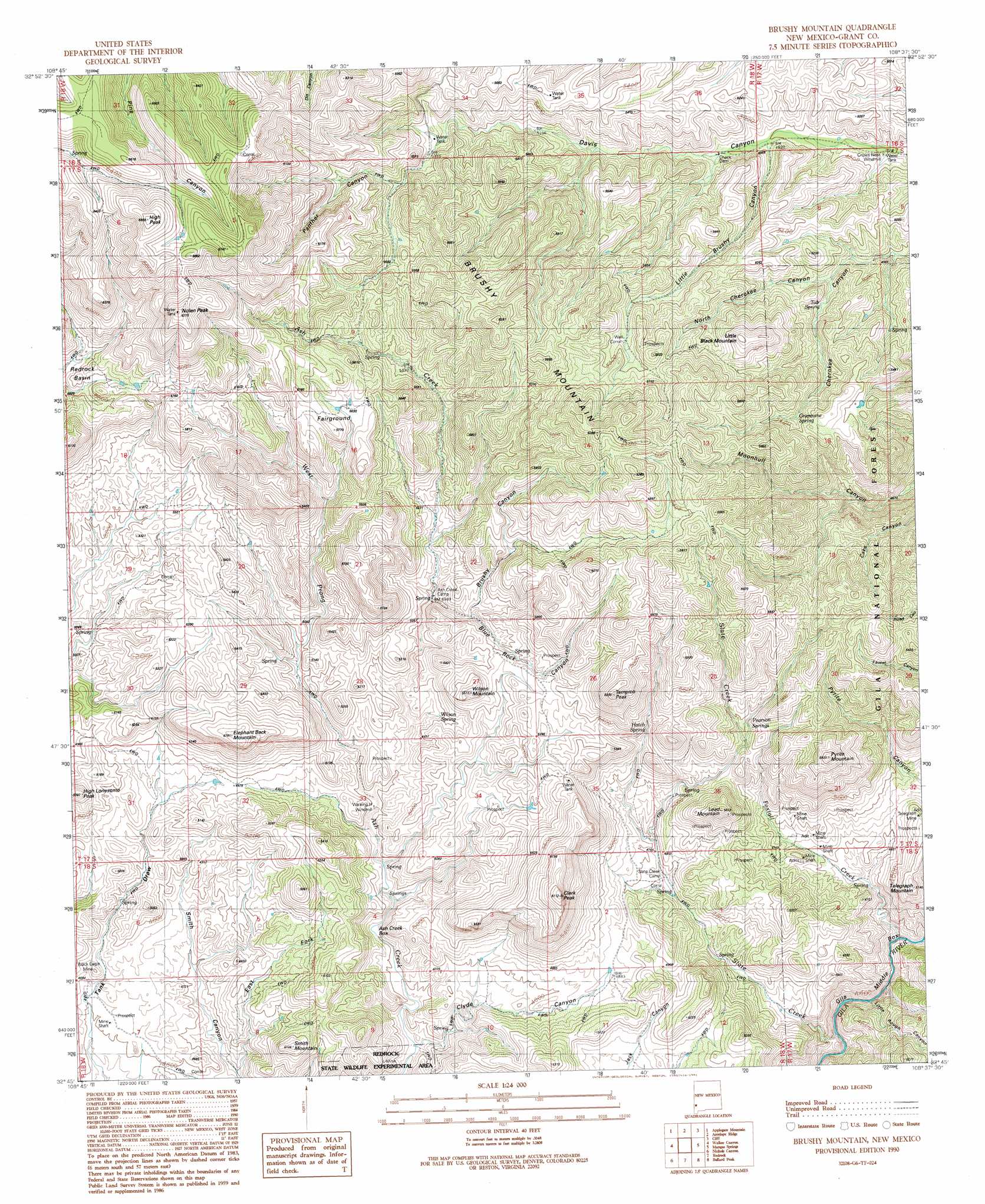
Brushy Mountain Topo Map New Mexico
To zoom in, hover over the map of Brushy Mountain
USGS Topo Quad 32108g6 - 1:24,000 scale
| Topo Map Name: | Brushy Mountain |
| USGS Topo Quad ID: | 32108g6 |
| Print Size: | ca. 21 1/4" wide x 27" high |
| Southeast Coordinates: | 32.75° N latitude / 108.625° W longitude |
| Map Center Coordinates: | 32.8125° N latitude / 108.6875° W longitude |
| U.S. State: | NM |
| Filename: | o32108g6.jpg |
| Download Map JPG Image: | Brushy Mountain topo map 1:24,000 scale |
| Map Type: | Topographic |
| Topo Series: | 7.5´ |
| Map Scale: | 1:24,000 |
| Source of Map Images: | United States Geological Survey (USGS) |
| Alternate Map Versions: |
Brushy Mountain NM 1990, updated 1991 Download PDF Buy paper map Brushy Mountain NM 1999, updated 2002 Download PDF Buy paper map Brushy Mountain NM 2011 Download PDF Buy paper map Brushy Mountain NM 2013 Download PDF Buy paper map Brushy Mountain NM 2017 Download PDF Buy paper map |
| FStopo: | US Forest Service topo Brushy Mountain is available: Download FStopo PDF Download FStopo TIF |
1:24,000 Topo Quads surrounding Brushy Mountain
Mule Creek |
Bear Mountain |
Buckhorn |
Canteen Canyon |
Canyon Hill |
Crookson Peak |
Applegate Mountain |
Antelope Ridge |
Cliff |
Dorsey Ranch |
Steeple Rock |
Walker Canyon |
Brushy Mountain |
Mangas Springs |
Circle Mesa |
Canador Peak |
Nichols Canyon |
Redrock |
Bullard Peak |
Wind Mountain |
Rock Tank Draw |
Caprock Mountain |
Willow Draw |
Eagle Eye Peak |
Burro Peak |
> Back to 32108e1 at 1:100,000 scale
> Back to 32108a1 at 1:250,000 scale
> Back to U.S. Topo Maps home
Brushy Mountain topo map: Gazetteer
Brushy Mountain: Mines
Black Eagle Mine elevation 1428m 4685′Slate Creek Canyon Deposits elevation 1527m 5009′
Brushy Mountain: Reservoirs
Hells Hole Tank elevation 1642m 5387′Lower Slate Creek Tank elevation 1441m 4727′
Turner Tank elevation 1524m 5000′
Brushy Mountain: Springs
Foxtail Spring elevation 1360m 4461′Grapevine Spring elevation 1605m 5265′
Hatch Spring elevation 1576m 5170′
Pearson Springs elevation 1559m 5114′
South Black Spring elevation 1596m 5236′
Tub Spring elevation 1536m 5039′
Wilson Spring elevation 1523m 4996′
Brushy Mountain: Streams
Foxtail Creek elevation 1280m 4199′Slate Creek elevation 1266m 4153′
West Prong Ash Creek elevation 1456m 4776′
Brushy Mountain: Summits
Brushy Mountain elevation 1899m 6230′Clark Peak elevation 1862m 6108′
Elephant Back Mountain elevation 1756m 5761′
High Lonesome Peak elevation 1643m 5390′
High Peak elevation 2086m 6843′
Lead Mountain elevation 1681m 5515′
Little Black Mountain elevation 1762m 5780′
Nolen Peak elevation 2056m 6745′
Pyrite Mountain elevation 1789m 5869′
Smith Mountain elevation 1567m 5141′
Tampico Peak elevation 1850m 6069′
Telegraph Mountain elevation 1555m 5101′
Wilson Mountain elevation 1695m 5561′
Brushy Mountain: Valleys
Ash Creek Box elevation 1397m 4583′Blue Rock Canyon elevation 1524m 5000′
Brushy Canyon elevation 1546m 5072′
East Fork Smith Canyon elevation 1356m 4448′
Little Brushy Canyon elevation 1471m 4826′
Little Rough Canyon elevation 1295m 4248′
North Cherokee Canyon elevation 1496m 4908′
Panther Canyon elevation 1644m 5393′
Brushy Mountain digital topo map on disk
Buy this Brushy Mountain topo map showing relief, roads, GPS coordinates and other geographical features, as a high-resolution digital map file on DVD: