Applegate Mountain Topo Map New Mexico
To zoom in, hover over the map of Applegate Mountain
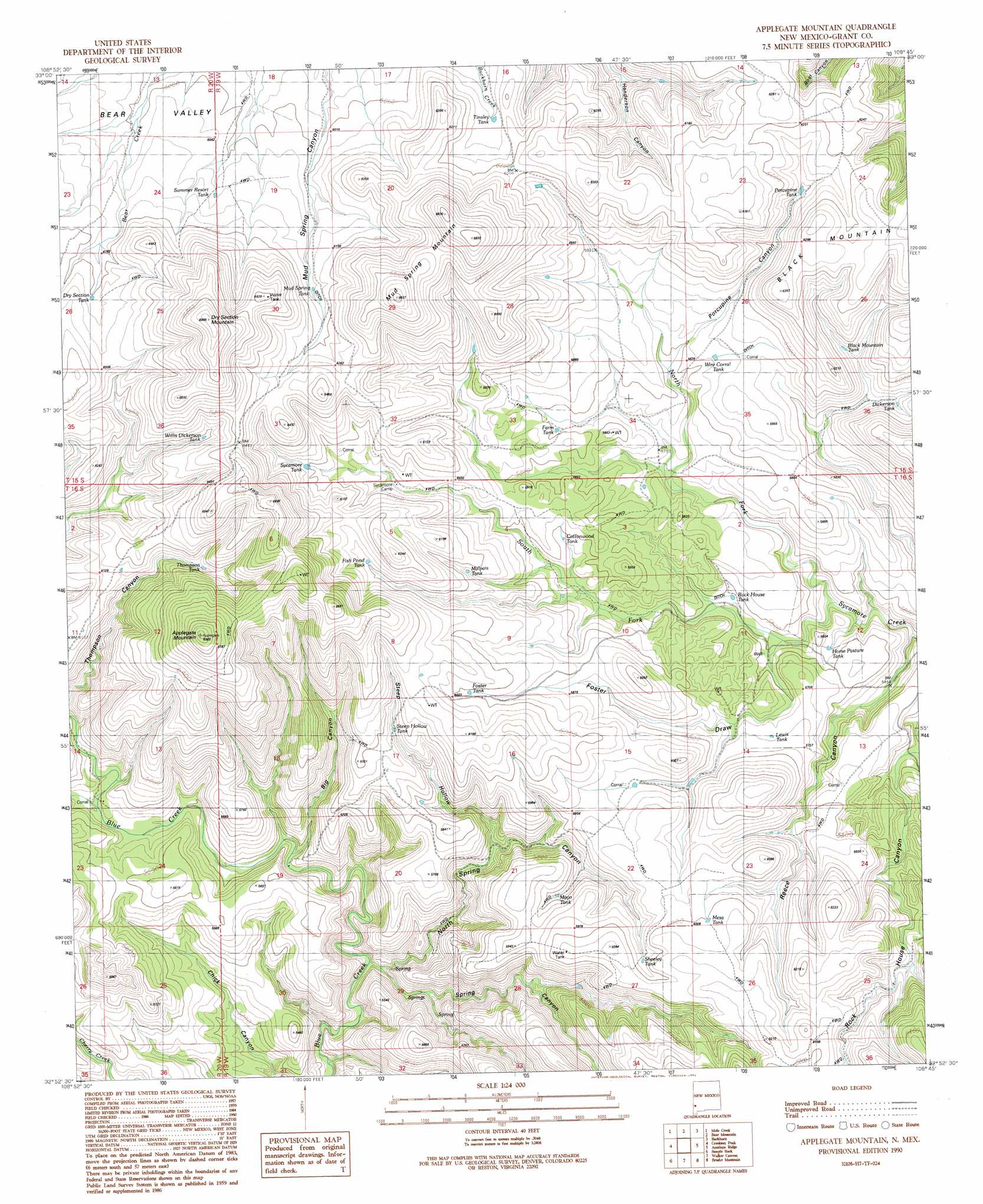
USGS Topo Quad 32108h7 - 1:24,000 scale
| Topo Map Name: | Applegate Mountain |
| USGS Topo Quad ID: | 32108h7 |
| Print Size: | ca. 21 1/4" wide x 27" high |
| Southeast Coordinates: | 32.875° N latitude / 108.75° W longitude |
| Map Center Coordinates: | 32.9375° N latitude / 108.8125° W longitude |
| U.S. State: | NM |
| Filename: | o32108h7.jpg |
| Download Map JPG Image: | Applegate Mountain topo map 1:24,000 scale |
| Map Type: | Topographic |
| Topo Series: | 7.5´ |
| Map Scale: | 1:24,000 |
| Source of Map Images: | United States Geological Survey (USGS) |
| Alternate Map Versions: |
Applegate Mountain NM 1990, updated 1991 Download PDF Buy paper map Applegate Mountain NM 2010 Download PDF Buy paper map Applegate Mountain NM 2013 Download PDF Buy paper map Applegate Mountain NM 2017 Download PDF Buy paper map |
1:24,000 Topo Quads surrounding Applegate Mountain
Harden Cienega |
Wilson Mountain |
Moon Ranch |
Rice Ranch |
Shelley Peak |
Big Lue Mountains |
Mule Creek |
Bear Mountain |
Buckhorn |
Canteen Canyon |
Tillie Hall Peak |
Crookson Peak |
Applegate Mountain |
Antelope Ridge |
Cliff |
Goat Camp Spring |
Steeple Rock |
Walker Canyon |
Brushy Mountain |
Mangas Springs |
Duncan |
Canador Peak |
Nichols Canyon |
Redrock |
Bullard Peak |
> Back to 32108e1 at 1:100,000 scale
> Back to 32108a1 at 1:250,000 scale
> Back to U.S. Topo Maps home
Applegate Mountain topo map: Gazetteer
Applegate Mountain: Reservoirs
Black Mountain Tank elevation 1792m 5879′Cottonwood Tank elevation 1764m 5787′
Dickerson Tank elevation 1778m 5833′
Dry Section Tank elevation 1891m 6204′
Farm Tank elevation 1766m 5793′
Fish Pond Tank elevation 1844m 6049′
Foster Tank elevation 1828m 5997′
Horse Pasture Tank elevation 1686m 5531′
Lewis Tank elevation 1742m 5715′
Malapi Tank elevation 1804m 5918′
Malpais Tank elevation 1802m 5912′
Mayo Tank elevation 1754m 5754′
Mesa Tank elevation 1831m 6007′
Mud Spring Tank elevation 1867m 6125′
Porcupine Tank elevation 1837m 6026′
Rock House Tank elevation 1703m 5587′
Sheeley Tank elevation 1809m 5935′
Steep Hollow Tank elevation 1793m 5882′
Summer Resort Tank elevation 1853m 6079′
Sycamore Tank elevation 1826m 5990′
Thompson Tank elevation 1863m 6112′
Tinsley Tank elevation 1853m 6079′
Willis Dickerson Tank elevation 1884m 6181′
Wire Corral Tank elevation 1786m 5859′
Applegate Mountain: Streams
North Fork Sycamore Creek elevation 1664m 5459′South Fork Sycamore Creek elevation 1664m 5459′
Applegate Mountain: Summits
Applegate Mountain elevation 2125m 6971′Dry Section Mountain elevation 2127m 6978′
Mud Spring Mountain elevation 2083m 6833′
Applegate Mountain: Valleys
Big Canyon elevation 1620m 5314′Foster Draw elevation 1688m 5538′
North Spring Canyon elevation 1588m 5209′
Porcupine Canyon elevation 1767m 5797′
Reece Canyon elevation 1638m 5374′
Spring Canyon elevation 1569m 5147′
Steep Hollow elevation 1672m 5485′
Steep Hollow Spring Canyon elevation 1870m 6135′
Applegate Mountain digital topo map on disk
Buy this Applegate Mountain topo map showing relief, roads, GPS coordinates and other geographical features, as a high-resolution digital map file on DVD: