Cochise Head Topo Map Arizona
To zoom in, hover over the map of Cochise Head
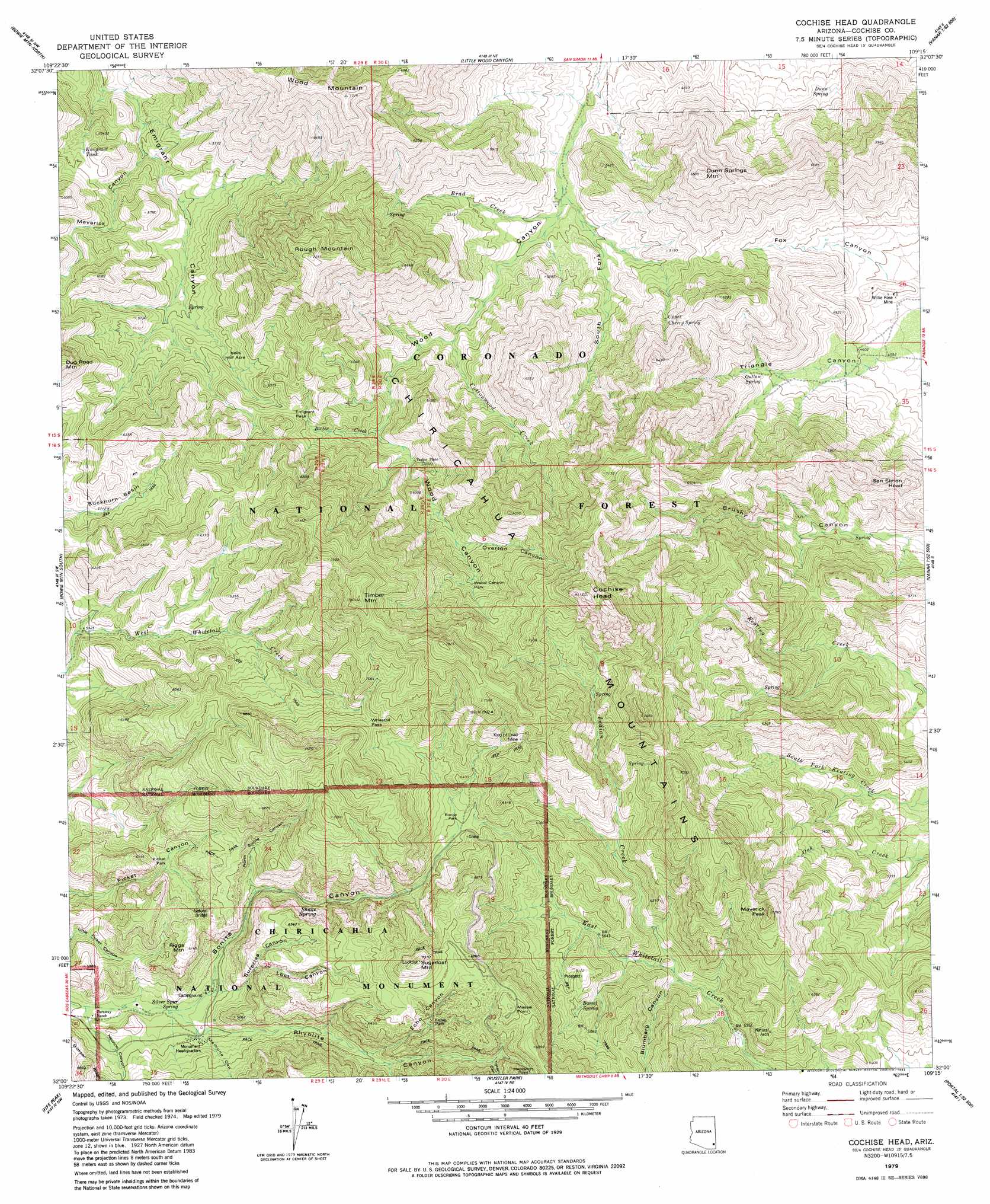
USGS Topo Quad 32109a3 - 1:24,000 scale
| Topo Map Name: | Cochise Head |
| USGS Topo Quad ID: | 32109a3 |
| Print Size: | ca. 21 1/4" wide x 27" high |
| Southeast Coordinates: | 32° N latitude / 109.25° W longitude |
| Map Center Coordinates: | 32.0625° N latitude / 109.3125° W longitude |
| U.S. State: | AZ |
| Filename: | o32109a3.jpg |
| Download Map JPG Image: | Cochise Head topo map 1:24,000 scale |
| Map Type: | Topographic |
| Topo Series: | 7.5´ |
| Map Scale: | 1:24,000 |
| Source of Map Images: | United States Geological Survey (USGS) |
| Alternate Map Versions: |
Cochise Head AZ 1979, updated 1979 Download PDF Buy paper map Cochise Head AZ 1979, updated 1983 Download PDF Buy paper map Cochise Head AZ 1979, updated 1983 Download PDF Buy paper map Cochise Head AZ 2012 Download PDF Buy paper map Cochise Head AZ 2014 Download PDF Buy paper map |
| FStopo: | US Forest Service topo Cochise Head is available: Download FStopo PDF Download FStopo TIF |
1:24,000 Topo Quads surrounding Cochise Head
Luzena |
Bowie |
Olga |
San Simon |
Doubtful Mountain |
Dos Cabezas |
Bowie Mountain North |
Little Wood Canyon |
Vanar Nw |
Vanar |
Pat Hills North |
Bowie Mountain South |
Cochise Head |
Blue Mountain |
San Simon Cienega |
Pat Hills South |
Fife Peak |
Rustler Park |
Portal |
Portal Ne |
Squaretop Hills East |
Stanford Canyon |
Chiricahua Peak |
Portal Peak |
Rodeo |
> Back to 32109a1 at 1:100,000 scale
> Back to 32108a1 at 1:250,000 scale
> Back to U.S. Topo Maps home
Cochise Head topo map: Gazetteer
Cochise Head: Arches
Chiricahua Natural Bridge elevation 1795m 5889′Cochise Head: Areas
Hells Half Acre elevation 1722m 5649′Cochise Head: Basins
Buckhorn Basin elevation 1746m 5728′Cochise Head: Cliffs
Inspiration Point elevation 2110m 6922′Cochise Head: Flats
Bonita Park elevation 1892m 6207′Echo Park elevation 1929m 6328′
Picket Park elevation 1730m 5675′
Wood Canyon Park elevation 1890m 6200′
Cochise Head: Gaps
Emigrant Pass elevation 1794m 5885′Whitetail Pass elevation 2046m 6712′
Cochise Head: Mines
King of Lead Mine elevation 2107m 6912′Willie Rose Mine elevation 1391m 4563′
Cochise Head: Parks
Chiricahua National Monument elevation 1645m 5396′Cochise Head: Populated Places
Taylor Place elevation 1682m 5518′Cochise Head: Reservoirs
Emigrant Tank elevation 1630m 5347′Cochise Head: Ridges
Erickson Ridge elevation 1779m 5836′Cochise Head: Springs
Barrel Spring elevation 1832m 6010′Bonita Spring elevation 1878m 6161′
Dunn Spring elevation 1436m 4711′
Outlaw Spring elevation 1502m 4927′
Shake Spring elevation 0m 0′
Silver Spur Spring elevation 1615m 5298′
Upper Cherry Spring elevation 1655m 5429′
Cochise Head: Streams
Bitter Creek elevation 1634m 5360′Brad Creek elevation 1440m 4724′
Cottonwood Creek elevation 1530m 5019′
Indian Creek elevation 1675m 5495′
Cochise Head: Summits
Cochise Head elevation 2465m 8087′Dunn Springs Mountain elevation 1979m 6492′
Massai Point elevation 2098m 6883′
Maverick Peak elevation 2199m 7214′
Riggs Mountain elevation 1868m 6128′
Rough Mountain elevation 2215m 7267′
San Simon Head elevation 0m 0′
Sugarloaf Mountain elevation 2222m 7290′
Timber Mountain elevation 2375m 7791′
Wood Mountain elevation 2226m 7303′
Cochise Head: Trails
East White Tail Trail Two Hundred Fiftythree elevation 1861m 6105′Emigrant Canyon Trail Two Hundred Fiftyfive elevation 1616m 5301′
Cochise Head: Valleys
Blumberg Canyon elevation 1674m 5492′Bonita Canyon elevation 1634m 5360′
Echo Canyon elevation 1776m 5826′
Lost Canyon elevation 1800m 5905′
Madrone Canyon elevation 1620m 5314′
Maverick Canyon elevation 1523m 4996′
Newton Canyon elevation 1594m 5229′
North Bonita Canyon elevation 1694m 5557′
Overton Canyon elevation 1788m 5866′
Rhyolite Canyon elevation 1641m 5383′
Sarah Deming Canyon elevation 0m 0′
South Fork Wood Canyon elevation 1439m 4721′
Surprise Canyon elevation 1634m 5360′
Totem Canyon elevation 1911m 6269′
Cochise Head digital topo map on disk
Buy this Cochise Head topo map showing relief, roads, GPS coordinates and other geographical features, as a high-resolution digital map file on DVD: