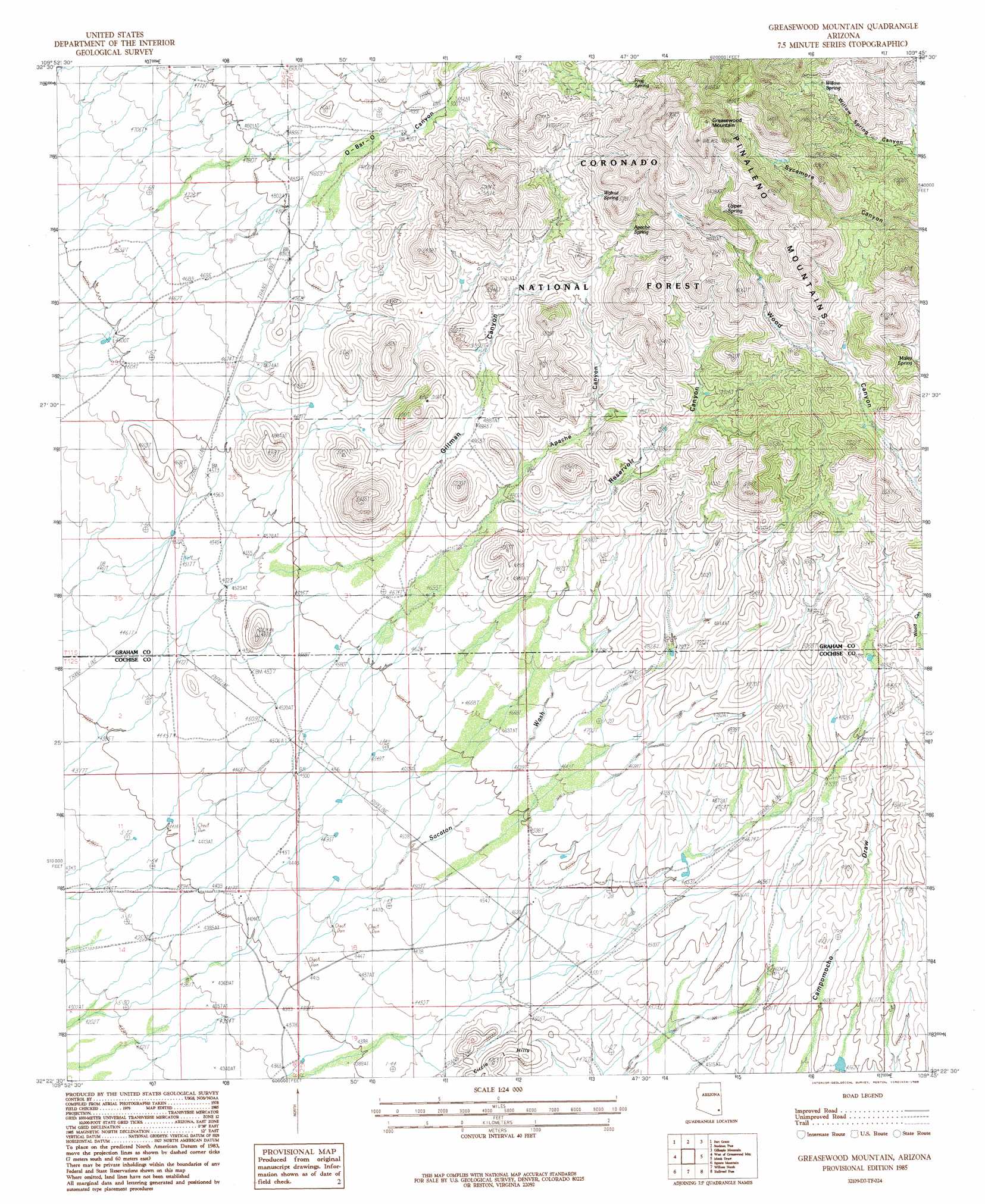
Greasewood Mountain Topo Map Arizona
To zoom in, hover over the map of Greasewood Mountain
USGS Topo Quad 32109d7 - 1:24,000 scale
| Topo Map Name: | Greasewood Mountain |
| USGS Topo Quad ID: | 32109d7 |
| Print Size: | ca. 21 1/4" wide x 27" high |
| Southeast Coordinates: | 32.375° N latitude / 109.75° W longitude |
| Map Center Coordinates: | 32.4375° N latitude / 109.8125° W longitude |
| U.S. State: | AZ |
| Filename: | o32109d7.jpg |
| Download Map JPG Image: | Greasewood Mountain topo map 1:24,000 scale |
| Map Type: | Topographic |
| Topo Series: | 7.5´ |
| Map Scale: | 1:24,000 |
| Source of Map Images: | United States Geological Survey (USGS) |
| Alternate Map Versions: |
Greasewood Mountain AZ 1985, updated 1985 Download PDF Buy paper map Greasewood Mountain AZ 1996, updated 2003 Download PDF Buy paper map Greasewood Mountain AZ 2011 Download PDF Buy paper map Greasewood Mountain AZ 2014 Download PDF Buy paper map |
| FStopo: | US Forest Service topo Greasewood Mountain is available: Download FStopo PDF Download FStopo TIF |
1:24,000 Topo Quads surrounding Greasewood Mountain
Blue Jay Peak |
Webb Peak |
Mount Graham |
Artesia |
Artesia Ne |
Sierra Bonita Ranch |
Fort Grant |
Stockton Pass |
Gillespie Mountain |
Tanque |
Reiley Peak |
West Of Greasewood Mountain |
Greasewood Mountain |
Monk Draw |
Fisher Hills |
Muskhog Mountain |
Square Mountain |
Willcox North |
Railroad Pass |
Luzena |
Steele Hills |
Red Bird Hills |
Willcox South |
Simmons Peak |
Dos Cabezas |
> Back to 32109a1 at 1:100,000 scale
> Back to 32108a1 at 1:250,000 scale
> Back to U.S. Topo Maps home
Greasewood Mountain topo map: Gazetteer
Greasewood Mountain: Dams
Willow Dam Tank elevation 1648m 5406′Greasewood Mountain: Reservoirs
Big Tank elevation 1555m 5101′Corner Tank elevation 1429m 4688′
Deer Tank elevation 1607m 5272′
Gilman Tank elevation 1459m 4786′
Greasewood Tank elevation 1857m 6092′
Holly Tank elevation 1507m 4944′
Horse Pasture Tank elevation 1475m 4839′
Monk Tank elevation 1731m 5679′
Monk Tank elevation 1757m 5764′
Redtail Dam Tank elevation 1551m 5088′
Res Tank elevation 1585m 5200′
Reservoir Tank elevation 1579m 5180′
Upper Monk Tank elevation 1638m 5374′
Greasewood Mountain: Springs
Apache Spring elevation 1700m 5577′Frog Spring elevation 1753m 5751′
Malay Spring elevation 1629m 5344′
Upper Spring elevation 1830m 6003′
Walnut Spring elevation 1691m 5547′
Willow Spring elevation 1796m 5892′
Greasewood Mountain: Streams
Sacaton Wash elevation 0m 0′Greasewood Mountain: Summits
Greasewood Mountain elevation 2161m 7089′Greasewood Mountain: Valleys
Apache Canyon elevation 1447m 4747′Gillman Canyon elevation 1438m 4717′
Reservoir Canyon elevation 1453m 4767′
Greasewood Mountain digital topo map on disk
Buy this Greasewood Mountain topo map showing relief, roads, GPS coordinates and other geographical features, as a high-resolution digital map file on DVD: