Mount Graham Topo Map Arizona
To zoom in, hover over the map of Mount Graham
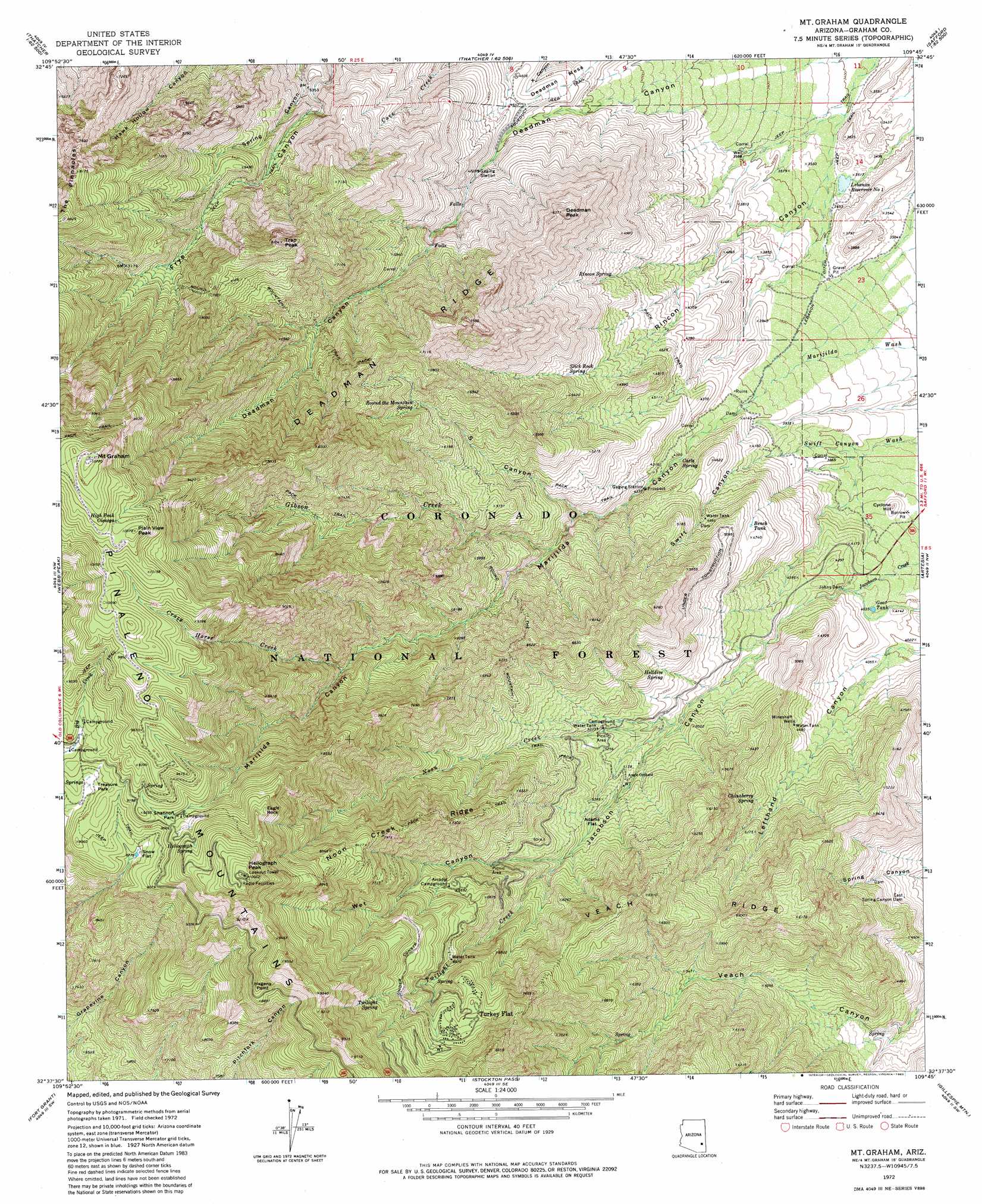
USGS Topo Quad 32109f7 - 1:24,000 scale
| Topo Map Name: | Mount Graham |
| USGS Topo Quad ID: | 32109f7 |
| Print Size: | ca. 21 1/4" wide x 27" high |
| Southeast Coordinates: | 32.625° N latitude / 109.75° W longitude |
| Map Center Coordinates: | 32.6875° N latitude / 109.8125° W longitude |
| U.S. State: | AZ |
| Filename: | o32109f7.jpg |
| Download Map JPG Image: | Mount Graham topo map 1:24,000 scale |
| Map Type: | Topographic |
| Topo Series: | 7.5´ |
| Map Scale: | 1:24,000 |
| Source of Map Images: | United States Geological Survey (USGS) |
| Alternate Map Versions: |
Mt. Graham AZ 1972, updated 1975 Download PDF Buy paper map Mt. Graham AZ 1972, updated 1983 Download PDF Buy paper map Mt. Graham AZ 1972, updated 1983 Download PDF Buy paper map Mount Graham AZ 1996, updated 2002 Download PDF Buy paper map Mount Graham AZ 2011 Download PDF Buy paper map Mount Graham AZ 2014 Download PDF Buy paper map |
| FStopo: | US Forest Service topo Mount Graham is available: Download FStopo PDF Download FStopo TIF |
1:24,000 Topo Quads surrounding Mount Graham
Telegraph Wash |
Eden |
Pima |
Weber Peak |
Lone Star Mountain |
Tripp Canyon |
Shingle Mill Mountain |
Thatcher |
Safford |
San Jose |
Blue Jay Peak |
Webb Peak |
Mount Graham |
Artesia |
Artesia Ne |
Sierra Bonita Ranch |
Fort Grant |
Stockton Pass |
Gillespie Mountain |
Tanque |
Reiley Peak |
West Of Greasewood Mountain |
Greasewood Mountain |
Monk Draw |
Fisher Hills |
> Back to 32109e1 at 1:100,000 scale
> Back to 32108a1 at 1:250,000 scale
> Back to U.S. Topo Maps home
Mount Graham topo map: Gazetteer
Mount Graham: Canals
Lebanon Ditch elevation 1072m 3517′Mount Graham: Cliffs
Hagens Point elevation 2702m 8864′Mount Graham: Dams
East Spring Canyon Dam elevation 1320m 4330′Johns Dam elevation 1255m 4117′
Mount Graham: Flats
Adams Flat elevation 1654m 5426′Snow Flat elevation 2681m 8795′
Mount Graham: Parks
Arcadia Recreation Area elevation 2031m 6663′Marijilda Picnic Grounds elevation 1310m 4297′
Noon Creek Picnic Grounds elevation 1588m 5209′
Shannon Park elevation 0m 0′
Shannon Recreation Area elevation 2760m 9055′
Snow Flat Boy Scout Camp elevation 2689m 8822′
Treasure Park elevation 2725m 8940′
West Canyon Picnic Grounds elevation 1845m 6053′
Mount Graham: Populated Places
Turkey Flat elevation 2295m 7529′Mount Graham: Ranges
Pinaleno Mountains elevation 2835m 9301′Mount Graham: Reservoirs
Bench Tank elevation 1435m 4708′Goat Tank elevation 1231m 4038′
Lebanon Reservoir Number One elevation 1062m 3484′
South Canyon Dam Tank elevation 1450m 4757′
Spring Canyon Dam Tank elevation 1376m 4514′
Mount Graham: Ridges
Deadman Ridge elevation 2159m 7083′Noon Creek Ridge elevation 2429m 7969′
The Pinnacles elevation 2491m 8172′
Veach Ridge elevation 2098m 6883′
Mount Graham: Springs
Carls Spring elevation 1292m 4238′Chinaberry Spring elevation 1492m 4895′
Heliograph Spring elevation 2839m 9314′
Helldive Spring elevation 1544m 5065′
High Peak Cienega elevation 3120m 10236′
Rincon Spring elevation 1412m 4632′
Round the Mountain Spring elevation 1902m 6240′
Slick Rock Spring elevation 1581m 5187′
Twilight Spring elevation 2343m 7687′
Mount Graham: Streams
Crazy Horse Creek elevation 1999m 6558′Gibson Creek elevation 1478m 4849′
Noon Creek elevation 1468m 4816′
Twilight Creek elevation 1727m 5666′
Mount Graham: Summits
Cyclone Hill elevation 1217m 3992′Deadman Mesa elevation 1355m 4445′
Deadman Peak elevation 1935m 6348′
Eagle Rock elevation 2851m 9353′
Heliograph Peak elevation 3050m 10006′
Mount Graham elevation 3260m 10695′
Plain View Peak elevation 3161m 10370′
Trap Peak elevation 2472m 8110′
Mount Graham: Trails
Gibson Canyon - Deadman Hiline Trail elevation 2622m 8602′Lady Bug Trail Three Hundred Twenty Nine elevation 2090m 6856′
Noon Creek Trail elevation 2267m 7437′
Round the Mountain Trail elevation 0m 0′
Mount Graham: Valleys
Jacobson Canyon elevation 1305m 4281′Marijilda Canyon elevation 1290m 4232′
S Canyon elevation 0m 0′
Swift Canyon elevation 1211m 3973′
Wet Canyon elevation 1735m 5692′
Mount Graham: Wells
Mineshaft Well elevation 1378m 4520′Mount Graham digital topo map on disk
Buy this Mount Graham topo map showing relief, roads, GPS coordinates and other geographical features, as a high-resolution digital map file on DVD: