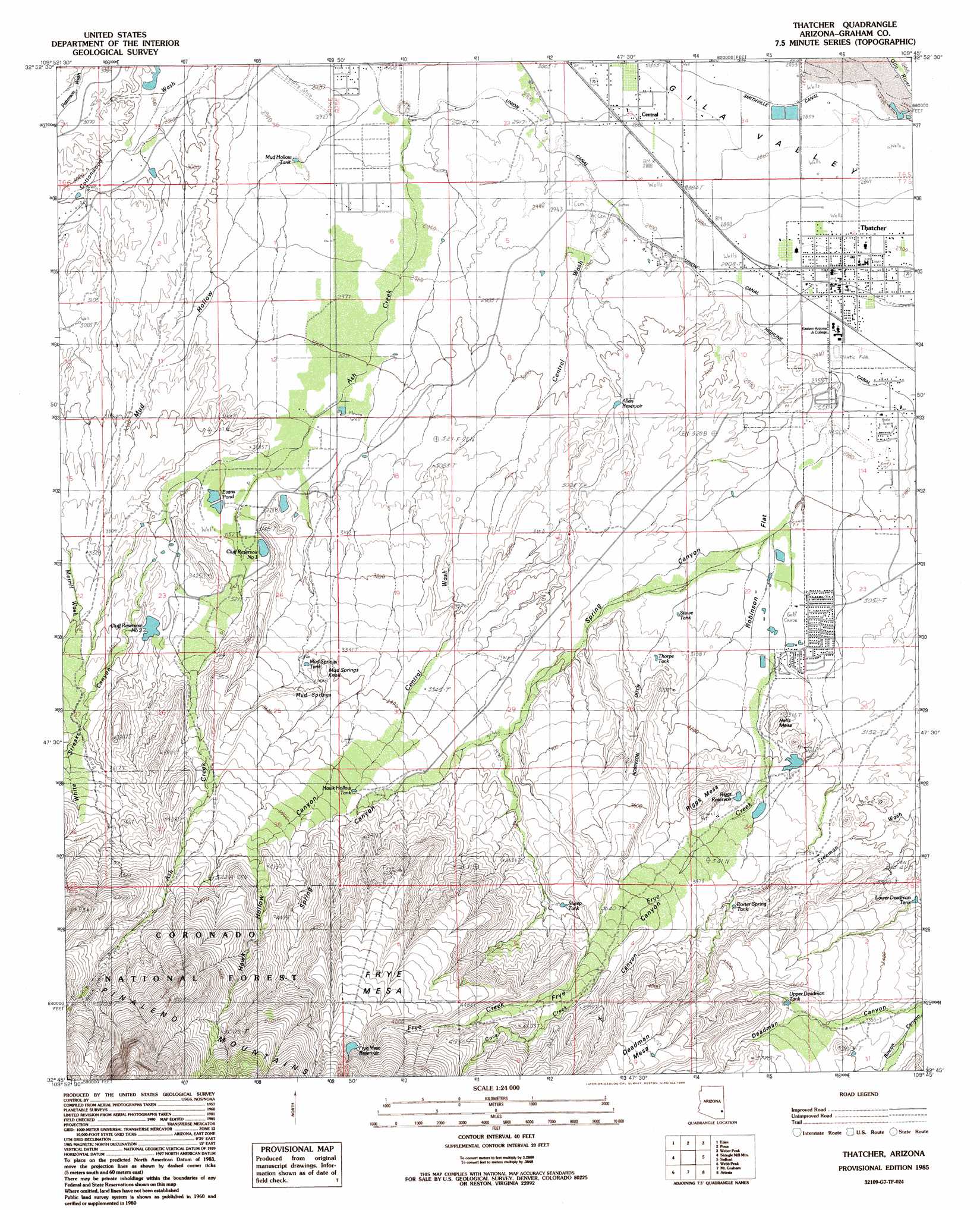
Thatcher Topo Map Arizona
To zoom in, hover over the map of Thatcher
USGS Topo Quad 32109g7 - 1:24,000 scale
| Topo Map Name: | Thatcher |
| USGS Topo Quad ID: | 32109g7 |
| Print Size: | ca. 21 1/4" wide x 27" high |
| Southeast Coordinates: | 32.75° N latitude / 109.75° W longitude |
| Map Center Coordinates: | 32.8125° N latitude / 109.8125° W longitude |
| U.S. State: | AZ |
| Filename: | o32109g7.jpg |
| Download Map JPG Image: | Thatcher topo map 1:24,000 scale |
| Map Type: | Topographic |
| Topo Series: | 7.5´ |
| Map Scale: | 1:24,000 |
| Source of Map Images: | United States Geological Survey (USGS) |
| Alternate Map Versions: |
Thatcher AZ 1985, updated 1985 Download PDF Buy paper map Thatcher AZ 1997, updated 2002 Download PDF Buy paper map Thatcher AZ 2011 Download PDF Buy paper map Thatcher AZ 2014 Download PDF Buy paper map |
| FStopo: | US Forest Service topo Thatcher is available: Download FStopo PDF Download FStopo TIF |
1:24,000 Topo Quads surrounding Thatcher
Geronimo |
Fort Thomas |
Markham Creek |
Bryce Mountain |
Bonita Spring |
Telegraph Wash |
Eden |
Pima |
Weber Peak |
Lone Star Mountain |
Tripp Canyon |
Shingle Mill Mountain |
Thatcher |
Safford |
San Jose |
Blue Jay Peak |
Webb Peak |
Mount Graham |
Artesia |
Artesia Ne |
Sierra Bonita Ranch |
Fort Grant |
Stockton Pass |
Gillespie Mountain |
Tanque |
> Back to 32109e1 at 1:100,000 scale
> Back to 32108a1 at 1:250,000 scale
> Back to U.S. Topo Maps home
Thatcher topo map: Gazetteer
Thatcher: Canals
Robinson Ditch elevation 1102m 3615′Smithville Canal elevation 868m 2847′
Thatcher: Dams
Central Detention Dam elevation 892m 2926′Cluff Ranch Number Three Dam elevation 1000m 3280′
Dave Lee Detention Dam elevation 909m 2982′
Frye Creek Retarding Dam elevation 904m 2965′
Frye Mesa Reservoir Dam elevation 1475m 4839′
Riggs Reservoir Dam elevation 977m 3205′
Savage Dam elevation 982m 3221′
Thatcher: Flats
Robinson Flat elevation 920m 3018′Thatcher: Parks
Sheriffs Posse Rodeo and Roping Area elevation 906m 2972′Thatcher: Populated Places
Central elevation 879m 2883′Thatcher elevation 887m 2910′
Thatcher: Post Offices
Central Post Office elevation 877m 2877′Thatcher Post Office elevation 888m 2913′
Thatcher: Reservoirs
Allen Reservoir elevation 917m 3008′Chandler Tank elevation 954m 3129′
Cluff Reservoir Number One elevation 962m 3156′
Cluff Reservoir Number Three elevation 1006m 3300′
Evans Pond elevation 954m 3129′
Frye Mesa Reservoir elevation 1475m 4839′
Hawk Hollow Tank elevation 1098m 3602′
Lower Deadman Tank elevation 998m 3274′
Mud Hollow Tank elevation 892m 2926′
Mud Springs Tank elevation 1020m 3346′
No Name Reservoir elevation 982m 3221′
Porter Spring Tank elevation 1039m 3408′
Riggs Reservoir elevation 1005m 3297′
Sheep Tank elevation 0m 0′
Stowe Tank elevation 942m 3090′
Thorpe Tank elevation 961m 3152′
Upper Deadman Tank elevation 1061m 3480′
Thatcher: Springs
Mud Springs elevation 1049m 3441′Porter Spring elevation 1006m 3300′
Thatcher: Streams
Cave Creek elevation 1162m 3812′Central Wash elevation 896m 2939′
Frye Creek elevation 901m 2956′
No Name Wash elevation 903m 2962′
No Name Wash elevation 973m 3192′
Thatcher: Summits
Frye Mesa elevation 1414m 4639′Halls Mesa elevation 984m 3228′
Mud Springs Knoll elevation 1065m 3494′
Riggs Mesa elevation 1104m 3622′
Thatcher: Trails
Ash Creek Trail Three Hundred Seven elevation 1509m 4950′Thatcher: Tunnels
McEnary Tunnel elevation 1281m 4202′Thatcher: Valleys
Deadman Canyon elevation 999m 3277′Frye Canyon elevation 1166m 3825′
Hawk Hollow Canyon elevation 923m 3028′
Mud Hollow elevation 889m 2916′
Rincon Canyon elevation 1001m 3284′
Spring Canyon elevation 960m 3149′
White Streaks Canyon elevation 952m 3123′
X Canyon elevation 1157m 3795′
Thatcher digital topo map on disk
Buy this Thatcher topo map showing relief, roads, GPS coordinates and other geographical features, as a high-resolution digital map file on DVD: