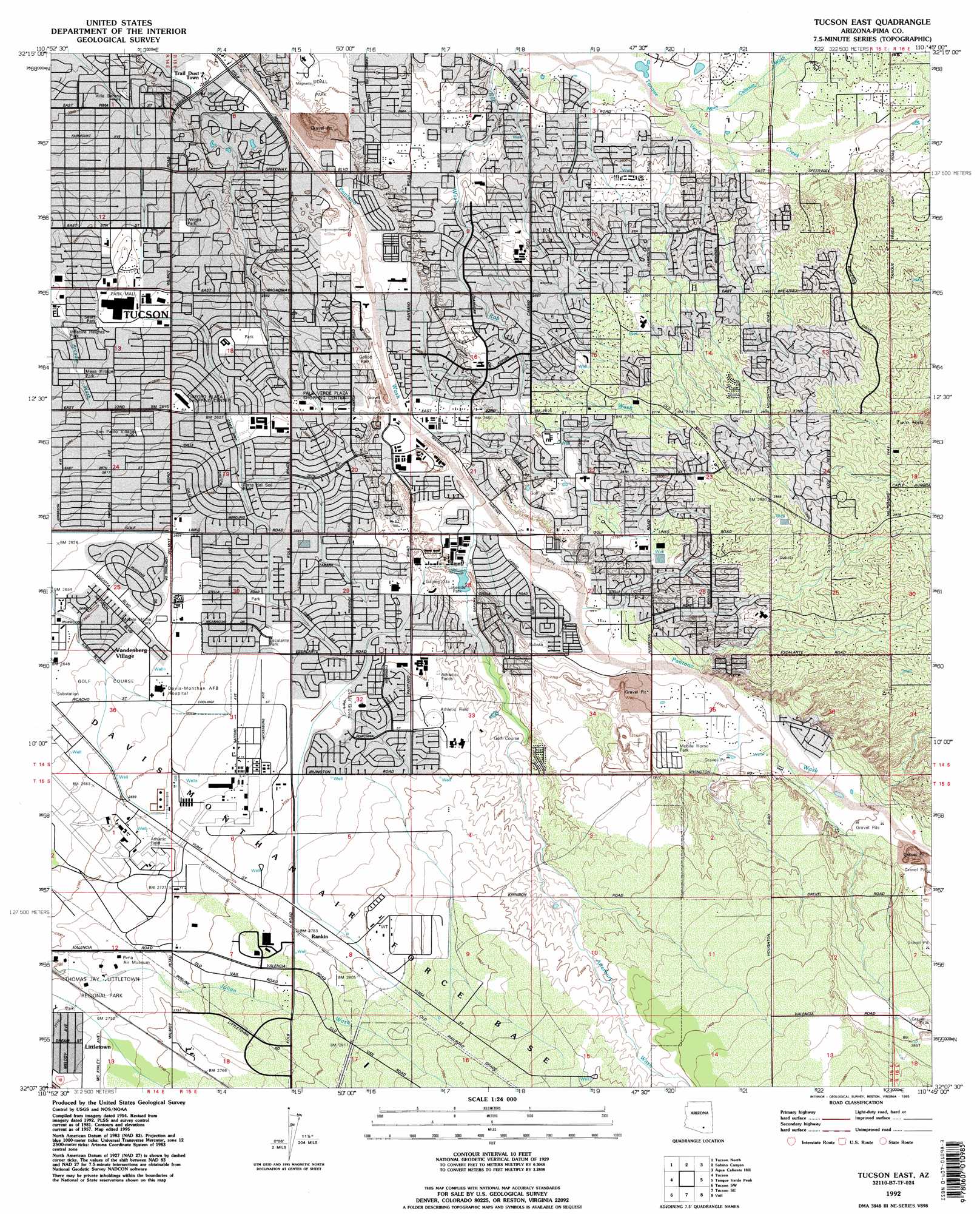
Tucson East Topo Map Arizona
To zoom in, hover over the map of Tucson East
USGS Topo Quad 32110b7 - 1:24,000 scale
| Topo Map Name: | Tucson East |
| USGS Topo Quad ID: | 32110b7 |
| Print Size: | ca. 21 1/4" wide x 27" high |
| Southeast Coordinates: | 32.125° N latitude / 110.75° W longitude |
| Map Center Coordinates: | 32.1875° N latitude / 110.8125° W longitude |
| U.S. State: | AZ |
| Filename: | o32110b7.jpg |
| Download Map JPG Image: | Tucson East topo map 1:24,000 scale |
| Map Type: | Topographic |
| Topo Series: | 7.5´ |
| Map Scale: | 1:24,000 |
| Source of Map Images: | United States Geological Survey (USGS) |
| Alternate Map Versions: |
Tucson East AZ 1957, updated 1958 Download PDF Buy paper map Tucson East AZ 1957, updated 1966 Download PDF Buy paper map Tucson East AZ 1957, updated 1973 Download PDF Buy paper map Tucson East AZ 1957, updated 1977 Download PDF Buy paper map Tucson East AZ 1983, updated 1983 Download PDF Buy paper map Tucson East AZ 1983, updated 1986 Download PDF Buy paper map Tucson East AZ 1992, updated 1995 Download PDF Buy paper map Tucson East AZ 1996, updated 2002 Download PDF Buy paper map Tucson East AZ 2011 Download PDF Buy paper map Tucson East AZ 2014 Download PDF Buy paper map |
1:24,000 Topo Quads surrounding Tucson East
Ruelas Canyon |
Oro Valley |
Mount Lemmon |
Mount Bigelow |
Buehman Canyon |
Jaynes |
Tucson North |
Sabino Canyon |
Agua Caliente Hill |
Piety Hill |
Cat Mountain |
Tucson |
Tucson East |
Tanque Verde Peak |
Mica Mountain |
San Xavier Mission |
Tucson Sw |
Tucson Se |
Vail |
Rincon Peak |
Twin Buttes |
Sahuarita |
Corona De Tucson |
Mount Fagan |
The Narrows |
> Back to 32110a1 at 1:100,000 scale
> Back to 32110a1 at 1:250,000 scale
> Back to U.S. Topo Maps home
Tucson East topo map: Gazetteer
Tucson East: Airports
Allied Airstrip elevation 837m 2746′Cregier Airport elevation 851m 2791′
Tucson East: Arroyos
Atterbury Wash elevation 831m 2726′Kinnison Wash elevation 824m 2703′
Tucson East: Crossings
Twenty-second Street Overpass elevation 848m 2782′Tucson East: Dams
Lakeside Park Dam elevation 824m 2703′Tucson East: Parks
Cedar Groves Park elevation 840m 2755′Escalante Park elevation 828m 2716′
Harold Bell Wright Park elevation 779m 2555′
Hearthstone Park elevation 818m 2683′
Jesse Owens Park elevation 806m 2644′
Lakeside Park elevation 823m 2700′
Lincoln Regional Park elevation 838m 2749′
Littletown Park elevation 826m 2709′
Mesa Village Park elevation 785m 2575′
Morris K Udall Regional Park elevation 777m 2549′
Palo Verde Park elevation 797m 2614′
San Paulo Village Park elevation 796m 2611′
Sears Park elevation 787m 2582′
Stefan Gollob Park elevation 795m 2608′
The Groves Park elevation 840m 2755′
Thomas Jay Regional Park elevation 827m 2713′
Tierra del Sol Park elevation 809m 2654′
Villa Serena Park elevation 766m 2513′
Vista del Prado Park elevation 823m 2700′
Wilshire Heights Park elevation 785m 2575′
Tucson East: Populated Places
Civano elevation 865m 2837′Kingston Knolls Terrace elevation 788m 2585′
Littletown elevation 828m 2716′
Rankin elevation 849m 2785′
Rolling Hills Country Club Estates elevation 818m 2683′
Vandenberg Village elevation 811m 2660′
Tucson East: Streams
Agua Caliente Wash elevation 778m 2552′Tucson East: Summits
Twin Hills elevation 903m 2962′Tucson East digital topo map on disk
Buy this Tucson East topo map showing relief, roads, GPS coordinates and other geographical features, as a high-resolution digital map file on DVD: