Reiley Peak Topo Map Arizona
To zoom in, hover over the map of Reiley Peak
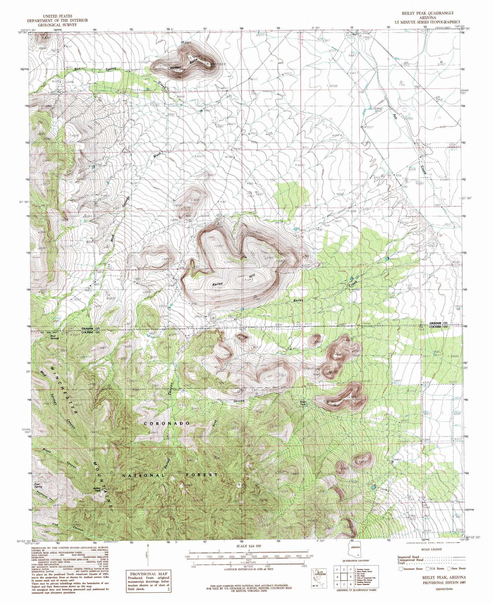
USGS Topo Quad 32110d1 - 1:24,000 scale
| Topo Map Name: | Reiley Peak |
| USGS Topo Quad ID: | 32110d1 |
| Print Size: | ca. 21 1/4" wide x 27" high |
| Southeast Coordinates: | 32.375° N latitude / 110° W longitude |
| Map Center Coordinates: | 32.4375° N latitude / 110.0625° W longitude |
| U.S. State: | AZ |
| Filename: | o32110d1.jpg |
| Download Map JPG Image: | Reiley Peak topo map 1:24,000 scale |
| Map Type: | Topographic |
| Topo Series: | 7.5´ |
| Map Scale: | 1:24,000 |
| Source of Map Images: | United States Geological Survey (USGS) |
| Alternate Map Versions: |
Reiley Peak AZ 1985, updated 1985 Download PDF Buy paper map Reiley Peak AZ 1996, updated 2003 Download PDF Buy paper map Reiley Peak AZ 2011 Download PDF Buy paper map Reiley Peak AZ 2014 Download PDF Buy paper map |
| FStopo: | US Forest Service topo Reiley Peak is available: Download FStopo PDF Download FStopo TIF |
1:24,000 Topo Quads surrounding Reiley Peak
Kennedy Peak |
Eureka Ranch |
Blue Jay Peak |
Webb Peak |
Mount Graham |
Bassett Peak |
Harrison Canyon |
Sierra Bonita Ranch |
Fort Grant |
Stockton Pass |
Cherry Spring Peak |
The Mesas |
Reiley Peak |
West Of Greasewood Mountain |
Greasewood Mountain |
Soza Mesa |
Hookers Hot Springs |
Muskhog Mountain |
Square Mountain |
Willcox North |
Wildhorse Mountain |
Deepwell Ranch |
Steele Hills |
Red Bird Hills |
Willcox South |
> Back to 32110a1 at 1:100,000 scale
> Back to 32110a1 at 1:250,000 scale
> Back to U.S. Topo Maps home
Reiley Peak topo map: Gazetteer
Reiley Peak: Airports
Lightning Ranch Airstrip elevation 1477m 4845′Reiley Peak: Reservoirs
Rose Tank elevation 1403m 4603′Upper Reiley Tank elevation 1500m 4921′
Reiley Peak: Springs
Mud Springs elevation 1608m 5275′Poer Spring elevation 1832m 6010′
Reiley Peak: Streams
Box Spring Creek elevation 1326m 4350′Mud Springs Wash elevation 1366m 4481′
Reiley Creek elevation 1314m 4311′
Reiley Peak: Summits
Hooker Butte elevation 1478m 4849′Reiley Hill elevation 1673m 5488′
Reiley Peak elevation 2319m 7608′
Reiley Peak: Valleys
Box Spring Canyon elevation 1415m 4642′Mud Springs Canyon elevation 1341m 4399′
Reiley Canyon elevation 1449m 4753′
Rose Canyon elevation 1415m 4642′
Sulphur Springs Valley elevation 1333m 4373′
Reiley Peak digital topo map on disk
Buy this Reiley Peak topo map showing relief, roads, GPS coordinates and other geographical features, as a high-resolution digital map file on DVD: