Redington Topo Map Arizona
To zoom in, hover over the map of Redington
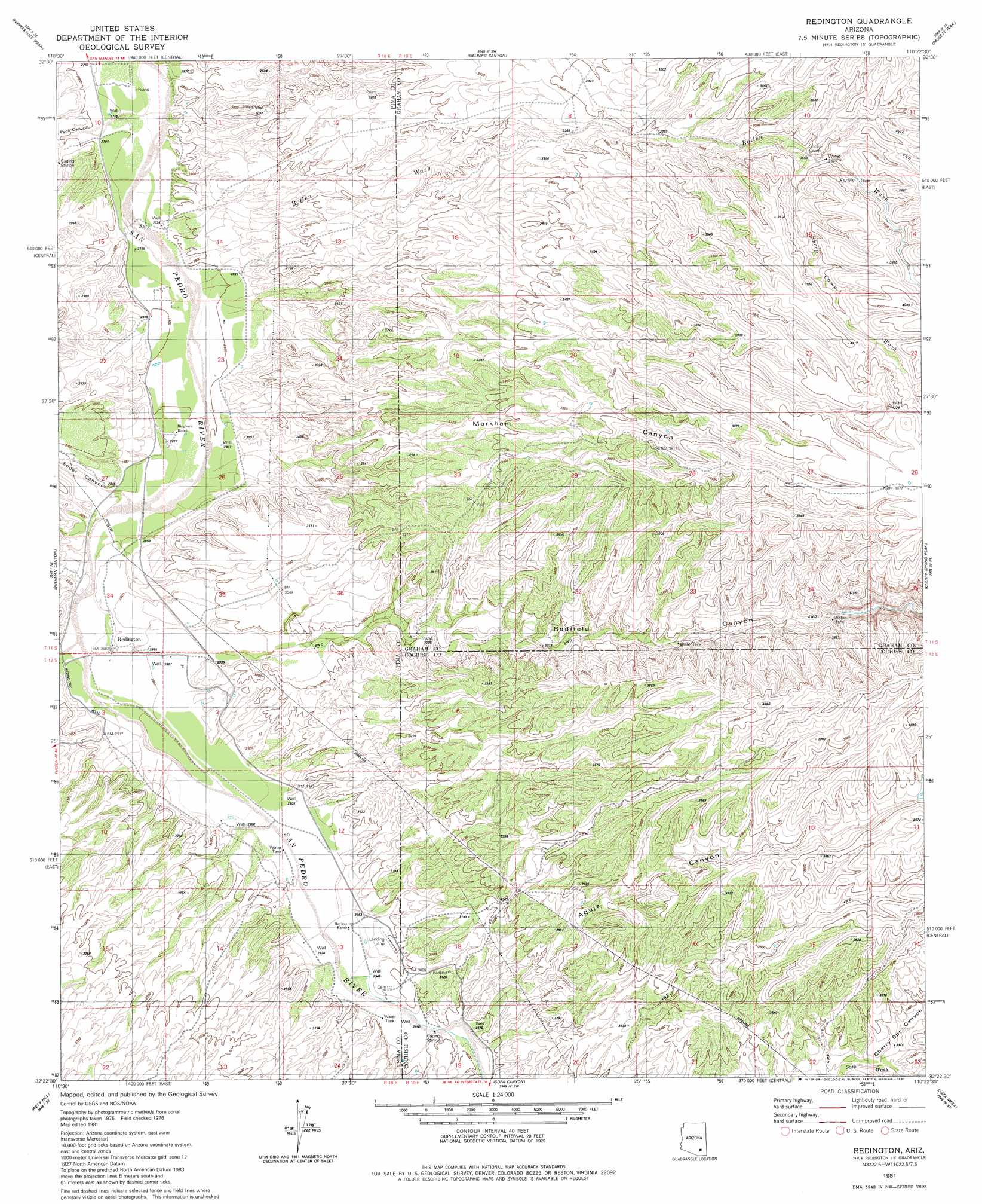
USGS Topo Quad 32110d4 - 1:24,000 scale
| Topo Map Name: | Redington |
| USGS Topo Quad ID: | 32110d4 |
| Print Size: | ca. 21 1/4" wide x 27" high |
| Southeast Coordinates: | 32.375° N latitude / 110.375° W longitude |
| Map Center Coordinates: | 32.4375° N latitude / 110.4375° W longitude |
| U.S. State: | AZ |
| Filename: | o32110d4.jpg |
| Download Map JPG Image: | Redington topo map 1:24,000 scale |
| Map Type: | Topographic |
| Topo Series: | 7.5´ |
| Map Scale: | 1:24,000 |
| Source of Map Images: | United States Geological Survey (USGS) |
| Alternate Map Versions: |
Redington AZ 1981, updated 1981 Download PDF Buy paper map Redington AZ 1981, updated 1981 Download PDF Buy paper map Redington AZ 1996, updated 2003 Download PDF Buy paper map Redington AZ 2011 Download PDF Buy paper map Redington AZ 2014 Download PDF Buy paper map |
1:24,000 Topo Quads surrounding Redington
Mammoth |
Clark Ranch |
Rhodes Peak |
Kennedy Peak |
Eureka Ranch |
Campo Bonito |
Peppersauce Wash |
Kielberg Canyon |
Bassett Peak |
Harrison Canyon |
Mount Bigelow |
Buehman Canyon |
Redington |
Cherry Spring Peak |
The Mesas |
Agua Caliente Hill |
Piety Hill |
Soza Canyon |
Soza Mesa |
Hookers Hot Springs |
Tanque Verde Peak |
Mica Mountain |
Happy Valley |
Wildhorse Mountain |
Deepwell Ranch |
> Back to 32110a1 at 1:100,000 scale
> Back to 32110a1 at 1:250,000 scale
> Back to U.S. Topo Maps home
Redington topo map: Gazetteer
Redington: Populated Places
Redington elevation 878m 2880′Redington: Streams
Bollen Wash elevation 841m 2759′Sheep Camp Wash elevation 0m 0′
Redington: Valleys
Aguja Canyon elevation 909m 2982′Cherry Spring Canyon elevation 1009m 3310′
Edgar Canyon elevation 873m 2864′
Markham Canyon elevation 875m 2870′
Peck Canyon elevation 851m 2791′
Redfield Canyon elevation 886m 2906′
Redington digital topo map on disk
Buy this Redington topo map showing relief, roads, GPS coordinates and other geographical features, as a high-resolution digital map file on DVD: