Mount Lemmon Topo Map Arizona
To zoom in, hover over the map of Mount Lemmon
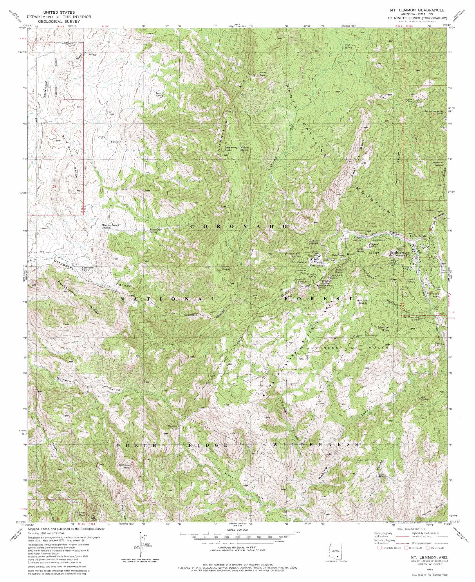
USGS Topo Quad 32110d7 - 1:24,000 scale
| Topo Map Name: | Mount Lemmon |
| USGS Topo Quad ID: | 32110d7 |
| Print Size: | ca. 21 1/4" wide x 27" high |
| Southeast Coordinates: | 32.375° N latitude / 110.75° W longitude |
| Map Center Coordinates: | 32.4375° N latitude / 110.8125° W longitude |
| U.S. State: | AZ |
| Filename: | o32110d7.jpg |
| Download Map JPG Image: | Mount Lemmon topo map 1:24,000 scale |
| Map Type: | Topographic |
| Topo Series: | 7.5´ |
| Map Scale: | 1:24,000 |
| Source of Map Images: | United States Geological Survey (USGS) |
| Alternate Map Versions: |
Mt. Lemmon AZ 1981, updated 1981 Download PDF Buy paper map Mt. Lemmon AZ 1981, updated 1984 Download PDF Buy paper map Mt. Lemmon AZ 1981, updated 1984 Download PDF Buy paper map Mount Lemmon AZ 1996, updated 2002 Download PDF Buy paper map Mount Lemmon AZ 2011 Download PDF Buy paper map Mount Lemmon AZ 2014 Download PDF Buy paper map |
| FStopo: | US Forest Service topo Mount Lemmon is available: Download FStopo PDF Download FStopo TIF |
1:24,000 Topo Quads surrounding Mount Lemmon
Chief Butte |
Fortified Peak |
North Of Oracle |
Mammoth |
Clark Ranch |
Tortolita Mountains |
Oracle Junction |
Oracle |
Campo Bonito |
Peppersauce Wash |
Ruelas Canyon |
Oro Valley |
Mount Lemmon |
Mount Bigelow |
Buehman Canyon |
Jaynes |
Tucson North |
Sabino Canyon |
Agua Caliente Hill |
Piety Hill |
Cat Mountain |
Tucson |
Tucson East |
Tanque Verde Peak |
Mica Mountain |
> Back to 32110a1 at 1:100,000 scale
> Back to 32110a1 at 1:250,000 scale
> Back to U.S. Topo Maps home
Mount Lemmon topo map: Gazetteer
Mount Lemmon: Areas
Wilderness of Rocks elevation 2223m 7293′Mount Lemmon: Flats
Lemmon Park elevation 2772m 9094′Mount Lemmon: Gaps
Marshall Saddle elevation 2400m 7874′Romero Pass elevation 1845m 6053′
Stratton Saddle elevation 2259m 7411′
Mount Lemmon: Mines
Hartman Homestake Mines elevation 1784m 5853′Mount Lemmon: Parks
Marshall Gulch Picnic Area elevation 2279m 7477′Santa Catalina Natural Area elevation 2193m 7194′
Mount Lemmon: Pillars
Cathedral Rock elevation 2387m 7831′Inspiration Rock elevation 2450m 8038′
Window Rock elevation 2218m 7276′
Mount Lemmon: Populated Places
Loma Linda elevation 2411m 7910′Summerhaven elevation 2337m 7667′
Mount Lemmon: Post Offices
Mount Lemmon Post Office elevation 2377m 7798′Summerhaven Post Office (historical) elevation 2334m 7657′
Mount Lemmon: Reservoirs
Cement Dam Tank elevation 1073m 3520′Cottonwood Tank elevation 957m 3139′
Mount Lemmon: Ridges
Baby Jesus Ridge elevation 1044m 3425′Radio Ridge elevation 2662m 8733′
Red Ridge elevation 2158m 7080′
Reef of Rock elevation 2305m 7562′
Samaniego Ridge elevation 2143m 7030′
Sutherland Ridge elevation 1523m 4996′
Mount Lemmon: Springs
Annabel Spring elevation 2655m 8710′Apache Spring elevation 1842m 6043′
Bill Williams Spring elevation 2641m 8664′
Box Spring elevation 2175m 7135′
Brinkley Spring elevation 2707m 8881′
Busch Spring elevation 2363m 7752′
Cargodera Spring elevation 1173m 3848′
Cascade Spring elevation 2723m 8933′
Cold Spring elevation 2472m 8110′
Dead Pine Spring elevation 2665m 8743′
Flicker Spring elevation 2635m 8645′
Huntsman Spring elevation 2293m 7522′
Iron Spring elevation 1303m 4274′
Kinglet Spring elevation 2570m 8431′
Lemmon Spring elevation 2526m 8287′
Pidgeon Spring elevation 2512m 8241′
Quartzite Spring elevation 2675m 8776′
Samaniego Spring elevation 1417m 4648′
Shovel Spring elevation 2200m 7217′
Walnut Spring elevation 2208m 7244′
Wild Cow Spring elevation 1500m 4921′
Wooden Trough Spring elevation 1186m 3891′
Mount Lemmon: Streams
Lemmon Creek elevation 1304m 4278′Mount Lemmon: Summits
Marshall Peak elevation 2530m 8300′Mount Lemmon elevation 2783m 9130′
Mule Ears elevation 2161m 7089′
Samaniego Peak elevation 2312m 7585′
Mount Lemmon: Trails
Cañada del Oro Four elevation 2251m 7385′Cargodera Canyon Six Trail elevation 1076m 3530′
Samaniego Ridge Seven Trail elevation 2257m 7404′
Mount Lemmon: Valleys
Carter Canyon elevation 2335m 7660′East Fork Cañada del Oro elevation 1492m 4895′
Lemmon Canyon elevation 1319m 4327′
Marshall Gulch elevation 2267m 7437′
West Fork Sabino Canyon elevation 1245m 4084′
Mount Lemmon digital topo map on disk
Buy this Mount Lemmon topo map showing relief, roads, GPS coordinates and other geographical features, as a high-resolution digital map file on DVD: