Oracle Topo Map Arizona
To zoom in, hover over the map of Oracle
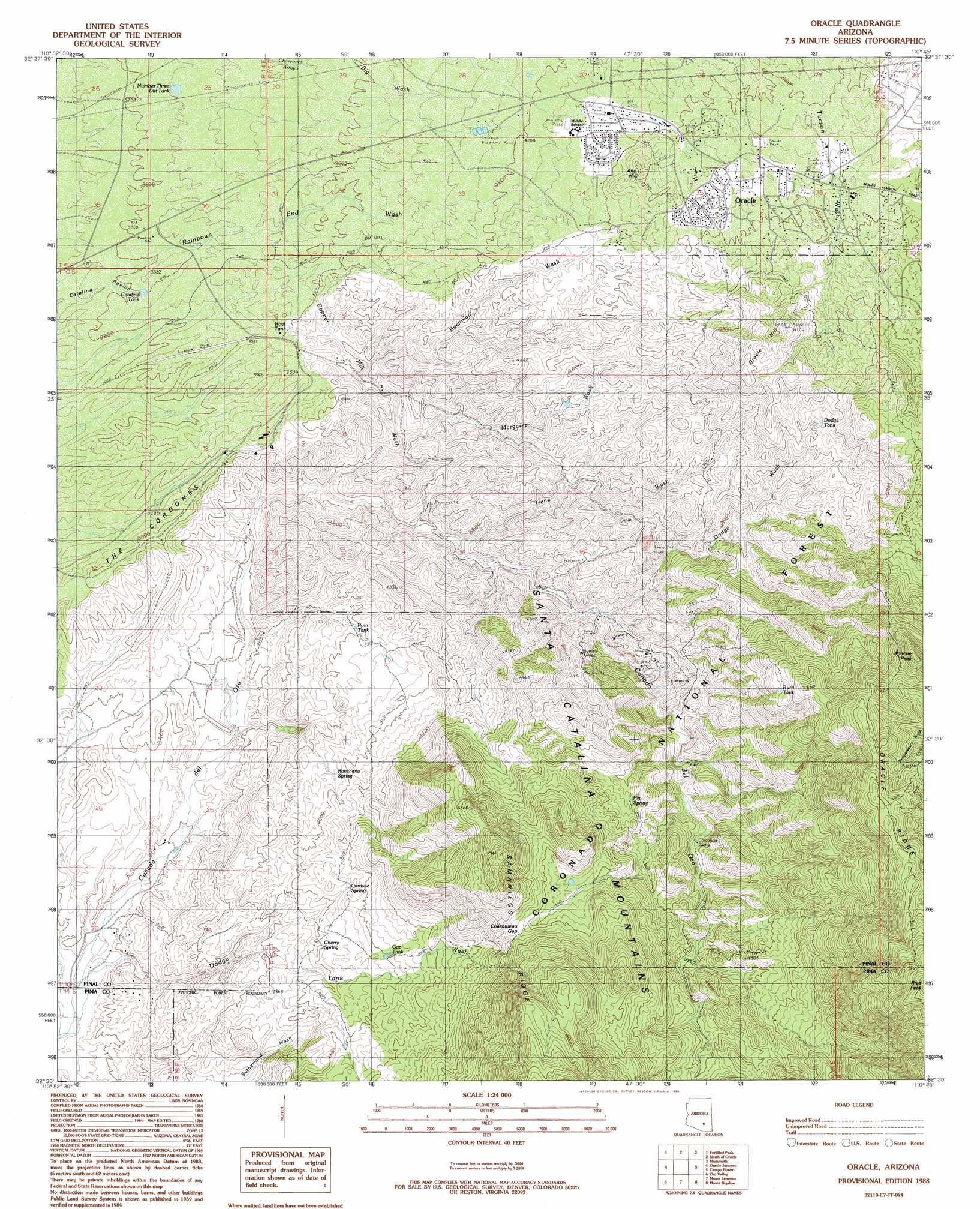
USGS Topo Quad 32110e7 - 1:24,000 scale
| Topo Map Name: | Oracle |
| USGS Topo Quad ID: | 32110e7 |
| Print Size: | ca. 21 1/4" wide x 27" high |
| Southeast Coordinates: | 32.5° N latitude / 110.75° W longitude |
| Map Center Coordinates: | 32.5625° N latitude / 110.8125° W longitude |
| U.S. State: | AZ |
| Filename: | o32110e7.jpg |
| Download Map JPG Image: | Oracle topo map 1:24,000 scale |
| Map Type: | Topographic |
| Topo Series: | 7.5´ |
| Map Scale: | 1:24,000 |
| Source of Map Images: | United States Geological Survey (USGS) |
| Alternate Map Versions: |
Oracle AZ 1988, updated 1989 Download PDF Buy paper map Oracle AZ 1996, updated 2002 Download PDF Buy paper map Oracle AZ 2011 Download PDF Buy paper map Oracle AZ 2014 Download PDF Buy paper map |
| FStopo: | US Forest Service topo Oracle is available: Download FStopo PDF Download FStopo TIF |
1:24,000 Topo Quads surrounding Oracle
Ninetysix Hills Se |
Black Mountain |
Putnam Wash |
Lookout Mountain |
Holy Joe Peak |
Chief Butte |
Fortified Peak |
North Of Oracle |
Mammoth |
Clark Ranch |
Tortolita Mountains |
Oracle Junction |
Oracle |
Campo Bonito |
Peppersauce Wash |
Ruelas Canyon |
Oro Valley |
Mount Lemmon |
Mount Bigelow |
Buehman Canyon |
Jaynes |
Tucson North |
Sabino Canyon |
Agua Caliente Hill |
Piety Hill |
> Back to 32110e1 at 1:100,000 scale
> Back to 32110a1 at 1:250,000 scale
> Back to U.S. Topo Maps home
Oracle topo map: Gazetteer
Oracle: Airports
Biosphere Two Landing Field elevation 1175m 3854′Little Hill Mines Incorporated Airport elevation 1185m 3887′
Oracle: Dams
Golder Dam elevation 1027m 3369′Oracle: Gaps
Charouleau Gap elevation 1550m 5085′Oracle: Mines
Burney Mines elevation 1301m 4268′Oracle: Parks
Oracle Park elevation 1401m 4596′Oracle: Populated Places
Casa del Oro elevation 1176m 3858′Oracle elevation 1379m 4524′
Saddle Brooke elevation 1015m 3330′
Oracle: Reservoirs
Burn Tank elevation 1595m 5232′Catalina Tank elevation 1161m 3809′
Dodge Tank elevation 1490m 4888′
Gap Tank elevation 1287m 4222′
Irene Well elevation 1350m 4429′
Lago del Oro elevation 1027m 3369′
Number Three Dirt Tank elevation 1172m 3845′
Roys Tank elevation 1204m 3950′
Ruin Tank elevation 1169m 3835′
Oracle: Springs
Carristo Spring elevation 1246m 4087′Cherry Spring elevation 1218m 3996′
Pig Spring elevation 1367m 4484′
Rancheria Spring elevation 1204m 3950′
Oracle: Streams
Bachman Wash elevation 1145m 3756′Copper Hill Wash elevation 1075m 3526′
Dodge Tank Wash elevation 944m 3097′
Dodge Wash elevation 1185m 3887′
Irene Wash elevation 1110m 3641′
Margaret Wash elevation 1108m 3635′
Oracle: Summits
Alto Hill elevation 1415m 4642′Apache Peak elevation 1960m 6430′
Oracle Hill elevation 1597m 5239′
Oracle: Valleys
Catalina Ravine elevation 1136m 3727′Oracle: Wells
Elise Well elevation 973m 3192′Oracle digital topo map on disk
Buy this Oracle topo map showing relief, roads, GPS coordinates and other geographical features, as a high-resolution digital map file on DVD: