Mammoth Topo Map Arizona
To zoom in, hover over the map of Mammoth
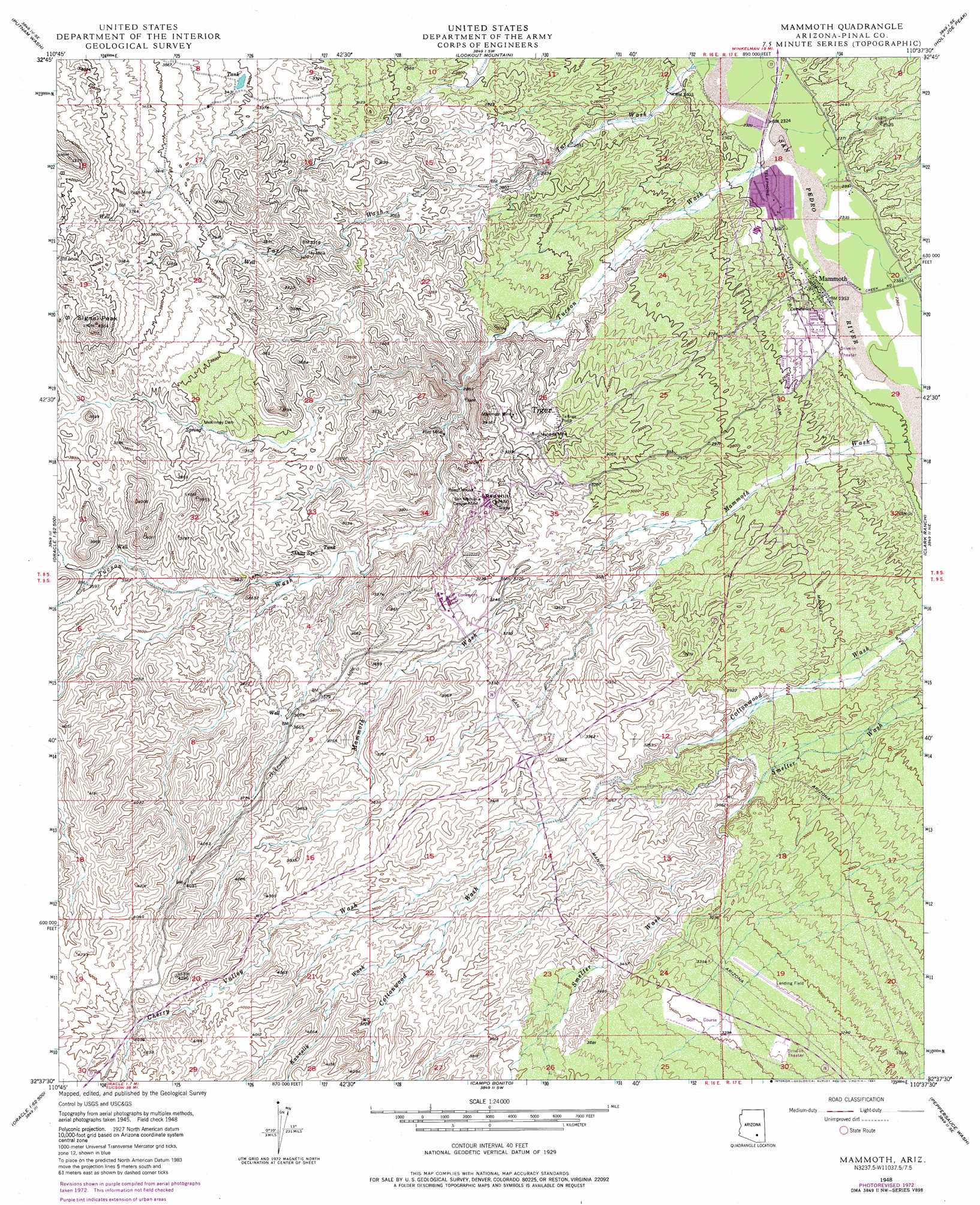
USGS Topo Quad 32110f6 - 1:24,000 scale
| Topo Map Name: | Mammoth |
| USGS Topo Quad ID: | 32110f6 |
| Print Size: | ca. 21 1/4" wide x 27" high |
| Southeast Coordinates: | 32.625° N latitude / 110.625° W longitude |
| Map Center Coordinates: | 32.6875° N latitude / 110.6875° W longitude |
| U.S. State: | AZ |
| Filename: | o32110f6.jpg |
| Download Map JPG Image: | Mammoth topo map 1:24,000 scale |
| Map Type: | Topographic |
| Topo Series: | 7.5´ |
| Map Scale: | 1:24,000 |
| Source of Map Images: | United States Geological Survey (USGS) |
| Alternate Map Versions: |
Mammoth AZ 1948, updated 1960 Download PDF Buy paper map Mammoth AZ 1948, updated 1973 Download PDF Buy paper map Mammoth AZ 1948, updated 1981 Download PDF Buy paper map Mammoth AZ 1949 Download PDF Buy paper map Mammoth AZ 1949 Download PDF Buy paper map Mammoth AZ 2011 Download PDF Buy paper map Mammoth AZ 2014 Download PDF Buy paper map |
1:24,000 Topo Quads surrounding Mammoth
Crozier Peak |
Winkelman |
Dudleyville |
Brandenburg Mountain |
Booger Canyon |
Black Mountain |
Putnam Wash |
Lookout Mountain |
Holy Joe Peak |
Oak Grove Canyon |
Fortified Peak |
North Of Oracle |
Mammoth |
Clark Ranch |
Rhodes Peak |
Oracle Junction |
Oracle |
Campo Bonito |
Peppersauce Wash |
Kielberg Canyon |
Oro Valley |
Mount Lemmon |
Mount Bigelow |
Buehman Canyon |
Redington |
> Back to 32110e1 at 1:100,000 scale
> Back to 32110a1 at 1:250,000 scale
> Back to U.S. Topo Maps home
Mammoth topo map: Gazetteer
Mammoth: Airports
San Manuel Airport elevation 994m 3261′Mammoth: Dams
McKinney Dam elevation 1058m 3471′Mammoth: Mines
Ford Mine elevation 901m 2956′Mammoth Mine elevation 984m 3228′
Mohawk Mine elevation 947m 3106′
Pearl Mine elevation 1139m 3736′
San Manuel Copper Mine elevation 0m 0′
Tar Mine elevation 1007m 3303′
Mammoth: Parks
Mammoth Softball Field Park elevation 721m 2365′Mammoth: Populated Places
Fordville elevation 902m 2959′Mammoth elevation 719m 2358′
North Mammoth elevation 720m 2362′
Tiger elevation 939m 3080′
Mammoth: Springs
Shultz Spring elevation 0m 0′Mammoth: Streams
Cherry Valley Wash elevation 998m 3274′Kannally Wash elevation 1068m 3503′
Mammoth Wash elevation 729m 2391′
Tar Wash elevation 704m 2309′
Tucson Wash elevation 720m 2362′
Mammoth: Summits
Black Hills elevation 1216m 3989′Red Hill elevation 1048m 3438′
Signal Peak elevation 0m 0′
Mammoth digital topo map on disk
Buy this Mammoth topo map showing relief, roads, GPS coordinates and other geographical features, as a high-resolution digital map file on DVD: