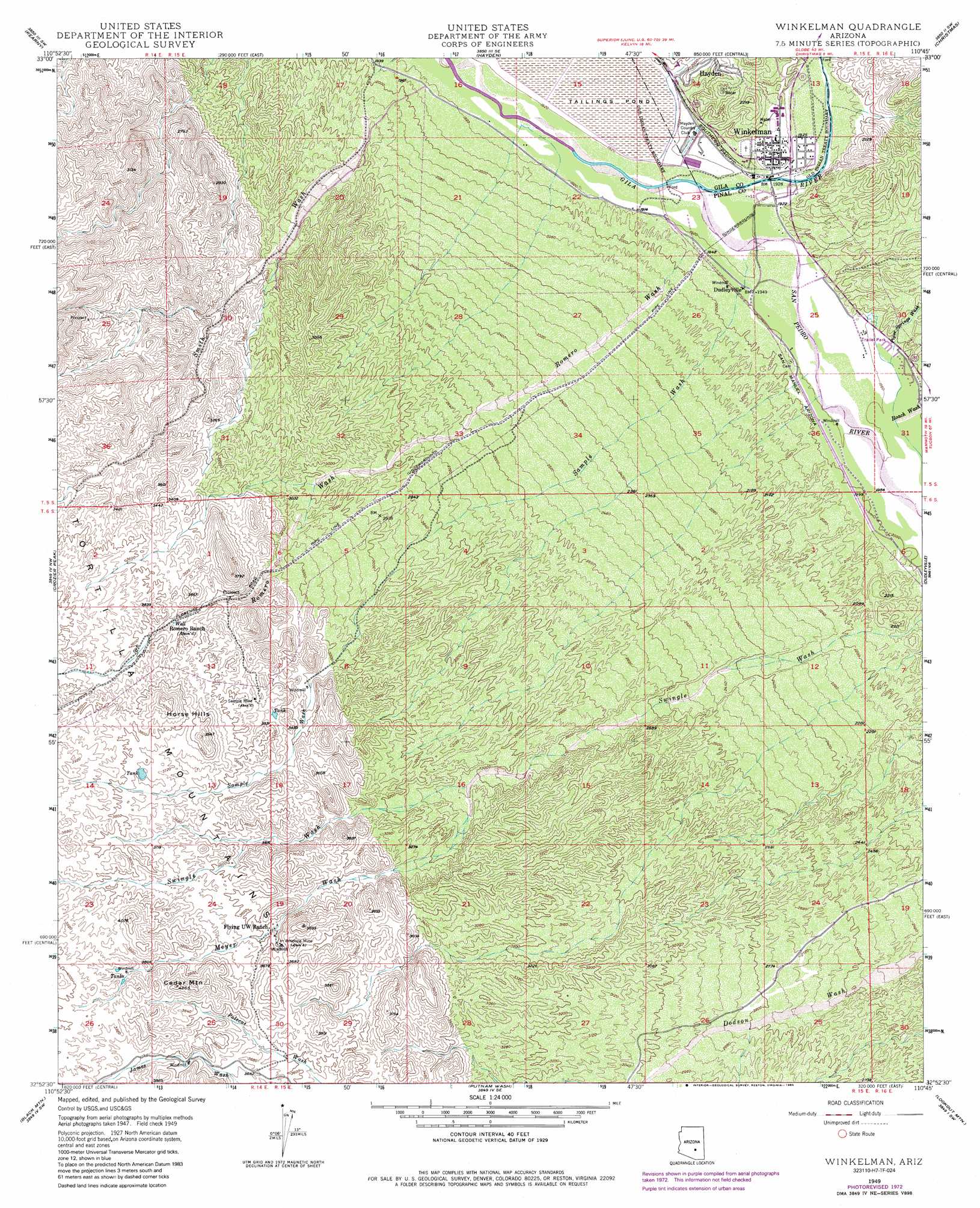
Winkelman Topo Map Arizona
To zoom in, hover over the map of Winkelman
USGS Topo Quad 32110h7 - 1:24,000 scale
| Topo Map Name: | Winkelman |
| USGS Topo Quad ID: | 32110h7 |
| Print Size: | ca. 21 1/4" wide x 27" high |
| Southeast Coordinates: | 32.875° N latitude / 110.75° W longitude |
| Map Center Coordinates: | 32.9375° N latitude / 110.8125° W longitude |
| U.S. State: | AZ |
| Filename: | o32110h7.jpg |
| Download Map JPG Image: | Winkelman topo map 1:24,000 scale |
| Map Type: | Topographic |
| Topo Series: | 7.5´ |
| Map Scale: | 1:24,000 |
| Source of Map Images: | United States Geological Survey (USGS) |
| Alternate Map Versions: |
Winkelman AZ 1949, updated 1960 Download PDF Buy paper map Winkelman AZ 1949, updated 1964 Download PDF Buy paper map Winkelman AZ 1949, updated 1973 Download PDF Buy paper map Winkelman AZ 1949, updated 1985 Download PDF Buy paper map Winkelman AZ 1950 Download PDF Buy paper map Winkelman AZ 2011 Download PDF Buy paper map Winkelman AZ 2014 Download PDF Buy paper map |
1:24,000 Topo Quads surrounding Winkelman
Teapot Mountain |
Hot Tamale Peak |
El Capitan Mountain |
Mescal Warm Spring |
Coolidge Dam |
Grayback |
Kearny |
Hayden |
Christmas |
Jerusalem Mountain |
Ninetysix Hills Ne |
Crozier Peak |
Winkelman |
Dudleyville |
Brandenburg Mountain |
Ninetysix Hills Se |
Black Mountain |
Putnam Wash |
Lookout Mountain |
Holy Joe Peak |
Chief Butte |
Fortified Peak |
North Of Oracle |
Mammoth |
Clark Ranch |
> Back to 32110e1 at 1:100,000 scale
> Back to 32110a1 at 1:250,000 scale
> Back to U.S. Topo Maps home
Winkelman topo map: Gazetteer
Winkelman: Mines
Antelope Mine elevation 1117m 3664′Sample Mine elevation 0m 0′
Winkelman: Populated Places
Dudleyville elevation 593m 1945′Winkelman elevation 600m 1968′
Winkelman: Post Offices
Winkelman Post Office elevation 600m 1968′Winkelman: Streams
James Wash elevation 1118m 3667′Meyer Wash elevation 923m 3028′
Piper Springs Wash elevation 606m 1988′
Roach Wash elevation 601m 1971′
Romero Wash elevation 596m 1955′
Sample Wash elevation 0m 0′
San Pedro River elevation 585m 1919′
Winkelman: Summits
Cedar Mountain elevation 1230m 4035′Horse Hills elevation 1197m 3927′
Winkelman digital topo map on disk
Buy this Winkelman topo map showing relief, roads, GPS coordinates and other geographical features, as a high-resolution digital map file on DVD: