Cat Mountain Topo Map Arizona
To zoom in, hover over the map of Cat Mountain
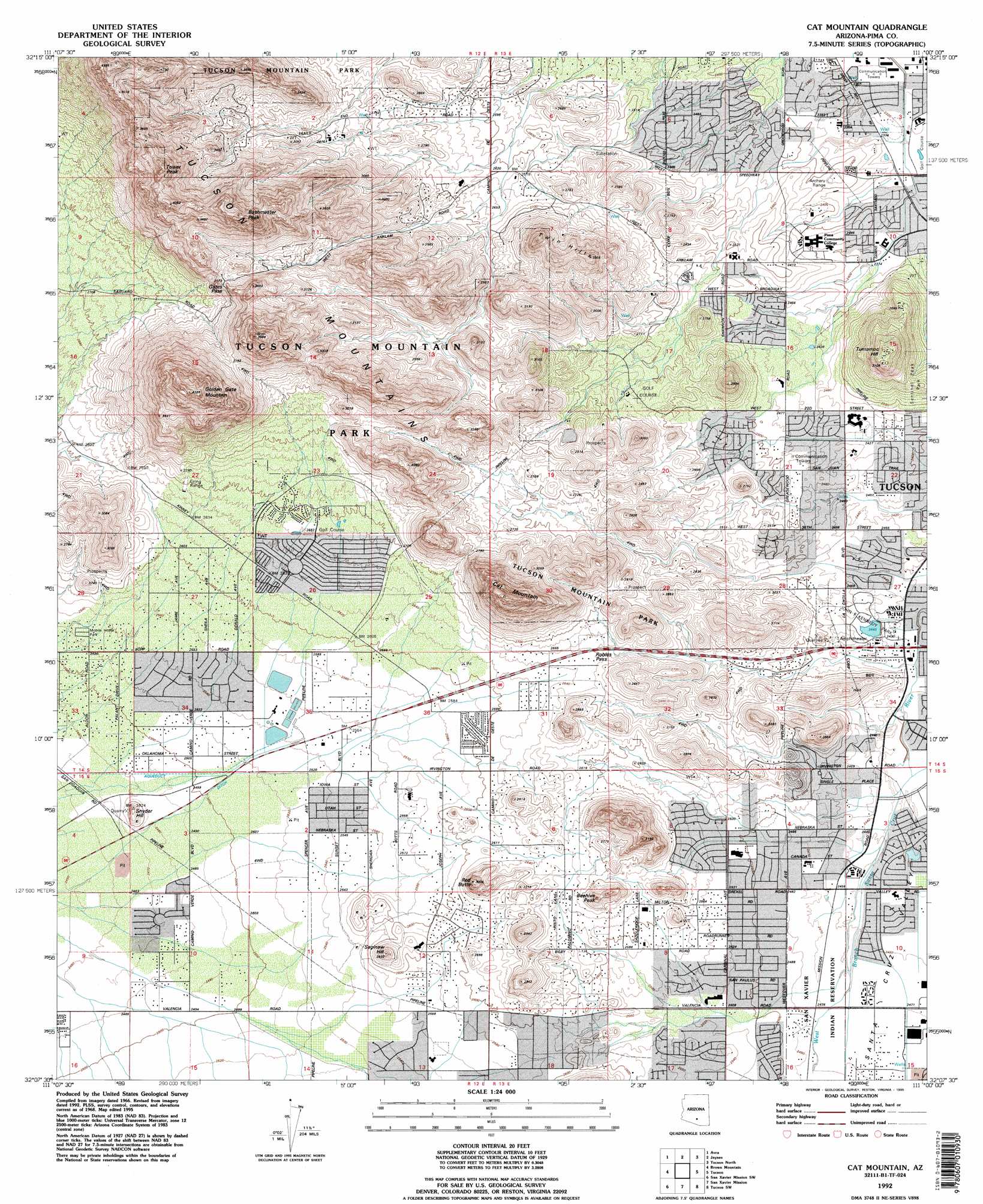
USGS Topo Quad 32111b1 - 1:24,000 scale
| Topo Map Name: | Cat Mountain |
| USGS Topo Quad ID: | 32111b1 |
| Print Size: | ca. 21 1/4" wide x 27" high |
| Southeast Coordinates: | 32.125° N latitude / 111° W longitude |
| Map Center Coordinates: | 32.1875° N latitude / 111.0625° W longitude |
| U.S. State: | AZ |
| Filename: | o32111b1.jpg |
| Download Map JPG Image: | Cat Mountain topo map 1:24,000 scale |
| Map Type: | Topographic |
| Topo Series: | 7.5´ |
| Map Scale: | 1:24,000 |
| Source of Map Images: | United States Geological Survey (USGS) |
| Alternate Map Versions: |
Cat Mountain AZ 1968, updated 1970 Download PDF Buy paper map Cat Mountain AZ 1968, updated 1977 Download PDF Buy paper map Cat Mountain AZ 1992, updated 1995 Download PDF Buy paper map Cat Mountain AZ 1996, updated 2002 Download PDF Buy paper map Cat Mountain AZ 2011 Download PDF Buy paper map Cat Mountain AZ 2014 Download PDF Buy paper map |
1:24,000 Topo Quads surrounding Cat Mountain
West Of Marana |
Marana |
Ruelas Canyon |
Oro Valley |
Mount Lemmon |
West Of Avra |
Avra |
Jaynes |
Tucson North |
Sabino Canyon |
Cocoraque Butte |
Brown Mountain |
Cat Mountain |
Tucson |
Tucson East |
Three Points |
San Xavier Mission Sw |
San Xavier Mission |
Tucson Sw |
Tucson Se |
Stevens Mountain |
Samaniego Peak |
Twin Buttes |
Sahuarita |
Corona De Tucson |
> Back to 32111a1 at 1:100,000 scale
> Back to 32110a1 at 1:250,000 scale
> Back to U.S. Topo Maps home
Cat Mountain topo map: Gazetteer
Cat Mountain: Airports
Saint Marys Helistop elevation 719m 2358′Cat Mountain: Dams
Kennedy Park Dam elevation 746m 2447′Cat Mountain: Gaps
Gates Pass elevation 966m 3169′Robles Pass elevation 809m 2654′
Cat Mountain: Parks
John F Kennedy Park elevation 748m 2454′Manzanita Winston Reynolds Park elevation 763m 2503′
Mission Ridge Park elevation 776m 2545′
Northwest Del Rio Park elevation 708m 2322′
San Juan Park elevation 744m 2440′
Speedway Greasewood Park elevation 751m 2463′
Vista del Pueblo Park elevation 738m 2421′
Cat Mountain: Populated Places
Drexel Heights elevation 770m 2526′Tucson Estates elevation 807m 2647′
Cat Mountain: Ranges
Tucson Mountains elevation 1197m 3927′Cat Mountain: Streams
Kennedy Park Creek elevation 733m 2404′Cat Mountain: Summits
Beehive Peak elevation 874m 2867′Bushmaster Peak elevation 1246m 4087′
Cat Mountain elevation 1169m 3835′
Golden Gate Mountain elevation 1300m 4265′
Red Butte elevation 909m 2982′
Saginaw Hill elevation 0m 0′
Snyder Hill elevation 787m 2582′
Tower Peak elevation 1224m 4015′
Tumamoc Hill elevation 947m 3106′
Twin Hills elevation 919m 3015′
Cat Mountain: Trails
San Juan Trail elevation 0m 0′Cat Mountain digital topo map on disk
Buy this Cat Mountain topo map showing relief, roads, GPS coordinates and other geographical features, as a high-resolution digital map file on DVD: