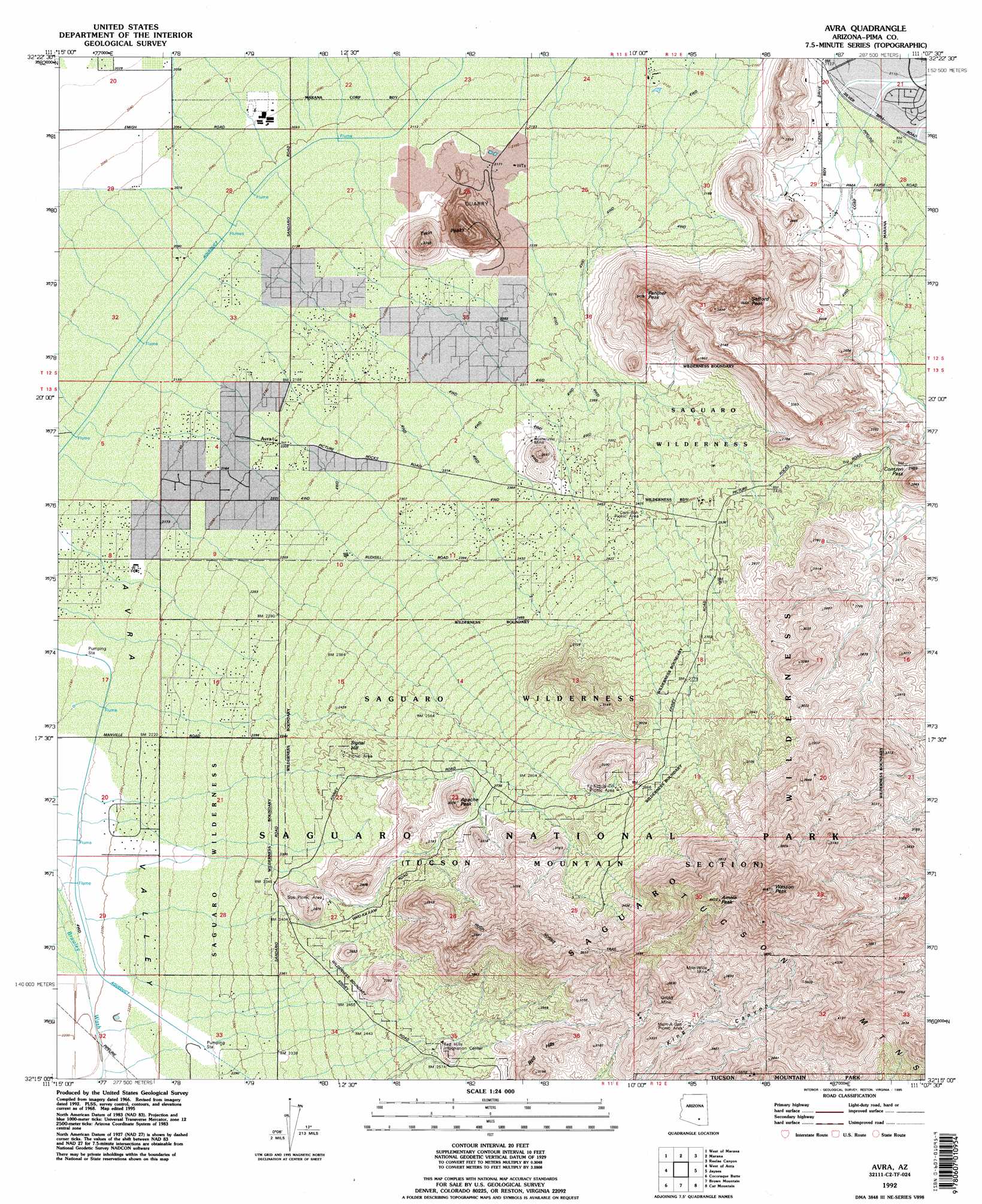
Avra Topo Map Arizona
To zoom in, hover over the map of Avra
USGS Topo Quad 32111c2 - 1:24,000 scale
| Topo Map Name: | Avra |
| USGS Topo Quad ID: | 32111c2 |
| Print Size: | ca. 21 1/4" wide x 27" high |
| Southeast Coordinates: | 32.25° N latitude / 111.125° W longitude |
| Map Center Coordinates: | 32.3125° N latitude / 111.1875° W longitude |
| U.S. State: | AZ |
| Filename: | o32111c2.jpg |
| Download Map JPG Image: | Avra topo map 1:24,000 scale |
| Map Type: | Topographic |
| Topo Series: | 7.5´ |
| Map Scale: | 1:24,000 |
| Source of Map Images: | United States Geological Survey (USGS) |
| Alternate Map Versions: |
Avra AZ 1968, updated 1969 Download PDF Buy paper map Avra AZ 1968, updated 1976 Download PDF Buy paper map Avra AZ 1968, updated 1993 Download PDF Buy paper map Avra AZ 1992, updated 1995 Download PDF Buy paper map Avra AZ 1996, updated 2001 Download PDF Buy paper map Avra AZ 2011 Download PDF Buy paper map Avra AZ 2014 Download PDF Buy paper map |
1:24,000 Topo Quads surrounding Avra
Samaniego Hills |
Red Rock |
Desert Peak |
Tortolita Mountains |
Oracle Junction |
Silver Bell East |
West Of Marana |
Marana |
Ruelas Canyon |
Oro Valley |
Waterman Peak |
West Of Avra |
Avra |
Jaynes |
Tucson North |
La Tortuga Butte |
Cocoraque Butte |
Brown Mountain |
Cat Mountain |
Tucson |
San Pedro |
Three Points |
San Xavier Mission Sw |
San Xavier Mission |
Tucson Sw |
> Back to 32111a1 at 1:100,000 scale
> Back to 32110a1 at 1:250,000 scale
> Back to U.S. Topo Maps home
Avra topo map: Gazetteer
Avra: Gaps
Contzen Pass elevation 761m 2496′Avra: Mines
Busterville Mine elevation 727m 2385′Gould Mine elevation 984m 3228′
Mile-Wide Mine elevation 1067m 3500′
Thunderbird Mine elevation 878m 2880′
Avra: Parks
Cam-Boh Picnic Area elevation 760m 2493′Ez-Kim-In-Zin Picnic Area elevation 906m 2972′
Saguaro National Park elevation 0m 0′
Sus Picnic Area elevation 761m 2496′
Tucson Mountain Wildlife Area elevation 915m 3001′
Valley View Picnic Area (historical) elevation 745m 2444′
Avra: Populated Places
Avra elevation 673m 2208′Picture Rocks elevation 634m 2080′
Avra: Summits
Amole Peak elevation 1337m 4386′Apache Peak elevation 933m 3061′
Panther Peak elevation 1043m 3421′
Picture Rocks elevation 871m 2857′
Red Hills elevation 942m 3090′
Safford Peak elevation 0m 0′
Signal Hill elevation 0m 0′
Twin Peaks elevation 838m 2749′
Wasson Peak elevation 1414m 4639′
Avra: Trails
Desert Discovery Nature Trail elevation 739m 2424′Hugh Norris Trail elevation 1122m 3681′
King Canyon Trail elevation 1003m 3290′
Sendero Esperanza Trail elevation 1015m 3330′
Sweetwater Trail elevation 1039m 3408′
Valley View Overlook Trail elevation 808m 2650′
Avra digital topo map on disk
Buy this Avra topo map showing relief, roads, GPS coordinates and other geographical features, as a high-resolution digital map file on DVD: