Ruelas Canyon Topo Map Arizona
To zoom in, hover over the map of Ruelas Canyon
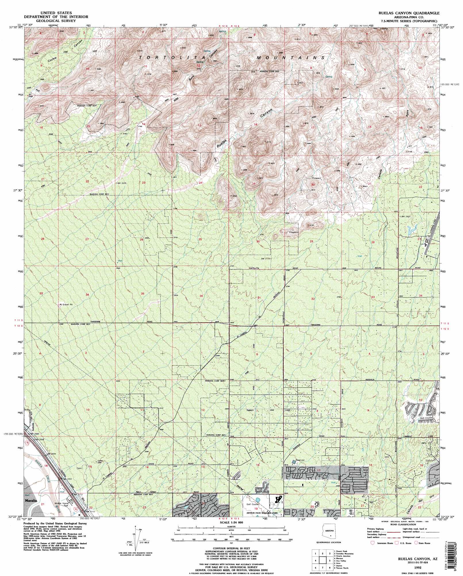
USGS Topo Quad 32111d1 - 1:24,000 scale
| Topo Map Name: | Ruelas Canyon |
| USGS Topo Quad ID: | 32111d1 |
| Print Size: | ca. 21 1/4" wide x 27" high |
| Southeast Coordinates: | 32.375° N latitude / 111° W longitude |
| Map Center Coordinates: | 32.4375° N latitude / 111.0625° W longitude |
| U.S. State: | AZ |
| Filename: | o32111d1.jpg |
| Download Map JPG Image: | Ruelas Canyon topo map 1:24,000 scale |
| Map Type: | Topographic |
| Topo Series: | 7.5´ |
| Map Scale: | 1:24,000 |
| Source of Map Images: | United States Geological Survey (USGS) |
| Alternate Map Versions: |
Ruelas Canyon AZ 1968, updated 1969 Download PDF Buy paper map Ruelas Canyon AZ 1968, updated 1975 Download PDF Buy paper map Ruelas Canyon AZ 1968, updated 1977 Download PDF Buy paper map Ruelas Canyon AZ 1992, updated 1995 Download PDF Buy paper map Ruelas Canyon AZ 1996, updated 2002 Download PDF Buy paper map Ruelas Canyon AZ 2011 Download PDF Buy paper map Ruelas Canyon AZ 2014 Download PDF Buy paper map |
1:24,000 Topo Quads surrounding Ruelas Canyon
Picacho Pass |
Durham Hills |
Chief Butte |
Fortified Peak |
North Of Oracle |
Red Rock |
Desert Peak |
Tortolita Mountains |
Oracle Junction |
Oracle |
West Of Marana |
Marana |
Ruelas Canyon |
Oro Valley |
Mount Lemmon |
West Of Avra |
Avra |
Jaynes |
Tucson North |
Sabino Canyon |
Cocoraque Butte |
Brown Mountain |
Cat Mountain |
Tucson |
Tucson East |
> Back to 32111a1 at 1:100,000 scale
> Back to 32110a1 at 1:250,000 scale
> Back to U.S. Topo Maps home
Ruelas Canyon topo map: Gazetteer
Ruelas Canyon: Airports
La Cholla Airpark elevation 886m 2906′Ruelas Canyon: Parks
Arthur Pack Regional Park elevation 729m 2391′Ruelas Canyon: Populated Places
Tortolita elevation 820m 2690′Ruelas Canyon: Ranges
Tortolita Mountains elevation 1135m 3723′Ruelas Canyon: Valleys
Cañada Agua elevation 896m 2939′Cochie Canyon elevation 807m 2647′
Ruelas Canyon elevation 0m 0′
Wild Burro Canyon elevation 851m 2791′
Ruelas Canyon digital topo map on disk
Buy this Ruelas Canyon topo map showing relief, roads, GPS coordinates and other geographical features, as a high-resolution digital map file on DVD: