Ninetysix Hills Ne Topo Map Arizona
To zoom in, hover over the map of Ninetysix Hills Ne
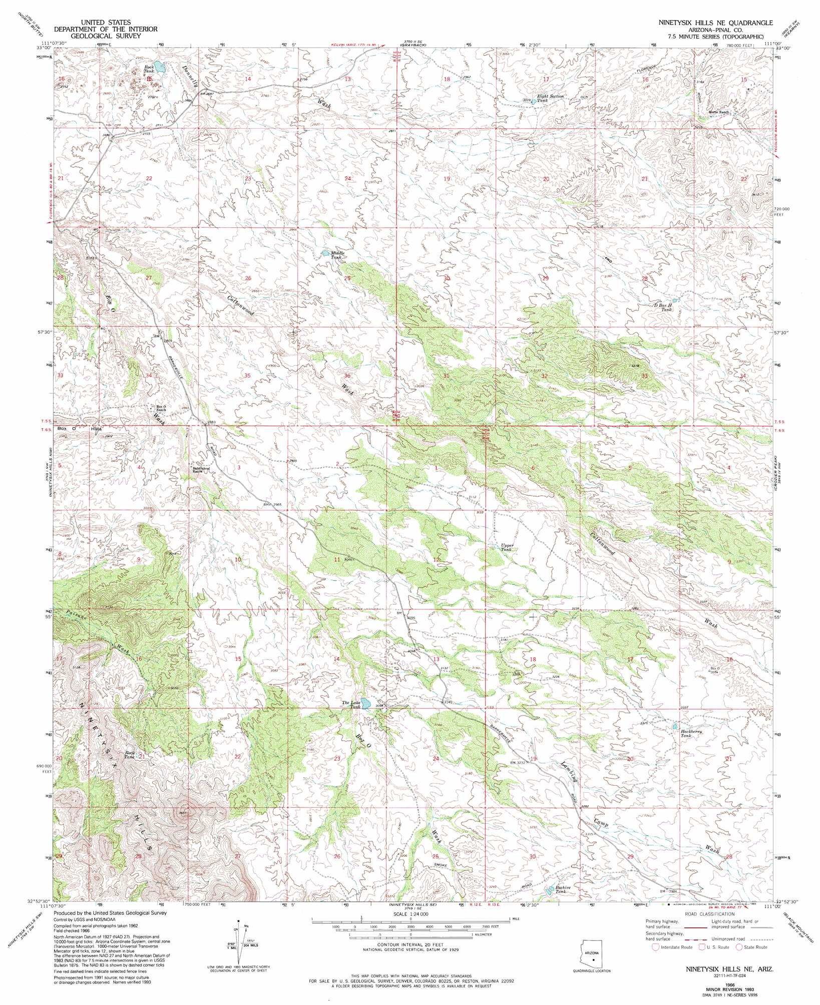
USGS Topo Quad 32111h1 - 1:24,000 scale
| Topo Map Name: | Ninetysix Hills Ne |
| USGS Topo Quad ID: | 32111h1 |
| Print Size: | ca. 21 1/4" wide x 27" high |
| Southeast Coordinates: | 32.875° N latitude / 111° W longitude |
| Map Center Coordinates: | 32.9375° N latitude / 111.0625° W longitude |
| U.S. State: | AZ |
| Filename: | o32111h1.jpg |
| Download Map JPG Image: | Ninetysix Hills Ne topo map 1:24,000 scale |
| Map Type: | Topographic |
| Topo Series: | 7.5´ |
| Map Scale: | 1:24,000 |
| Source of Map Images: | United States Geological Survey (USGS) |
| Alternate Map Versions: |
Ninetysix Hills NE AZ 1966, updated 1969 Download PDF Buy paper map Ninetysix Hills NE AZ 1966, updated 1978 Download PDF Buy paper map Ninetysix Hills NE AZ 1966, updated 1993 Download PDF Buy paper map Ninetysix Hills NE AZ 1997, updated 2003 Download PDF Buy paper map Ninetysix Hills NE AZ 2011 Download PDF Buy paper map Ninetysix Hills NE AZ 2014 Download PDF Buy paper map |
1:24,000 Topo Quads surrounding Ninetysix Hills Ne
Florence Ne |
Mineral Mountain |
Teapot Mountain |
Hot Tamale Peak |
El Capitan Mountain |
Florence Se |
North Butte |
Grayback |
Kearny |
Hayden |
Cactus Forest |
Ninetysix Hills Nw |
Ninetysix Hills Ne |
Crozier Peak |
Winkelman |
Picacho Reservoir Se |
Ninetysix Hills Sw |
Ninetysix Hills Se |
Black Mountain |
Putnam Wash |
Picacho Pass |
Durham Hills |
Chief Butte |
Fortified Peak |
North Of Oracle |
> Back to 32111e1 at 1:100,000 scale
> Back to 32110a1 at 1:250,000 scale
> Back to U.S. Topo Maps home
Ninetysix Hills Ne topo map: Gazetteer
Ninetysix Hills Ne: Reservoirs
Beehive Tank elevation 997m 3270′D Bar H Tank elevation 983m 3225′
Eight Section Tank elevation 924m 3031′
Hackberry Tank elevation 1016m 3333′
Middle Tank elevation 877m 2877′
Rock Tank elevation 811m 2660′
Rock Tank elevation 941m 3087′
The Lake Tank elevation 939m 3080′
Upper Tank elevation 958m 3143′
Ninetysix Hills Ne: Streams
Cottonwood Wash elevation 799m 2621′Lambing Camp Wash elevation 927m 3041′
Ninetysix Hills Ne: Summits
Ninetysix Hills elevation 1001m 3284′Ninetysix Hills Ne digital topo map on disk
Buy this Ninetysix Hills Ne topo map showing relief, roads, GPS coordinates and other geographical features, as a high-resolution digital map file on DVD: