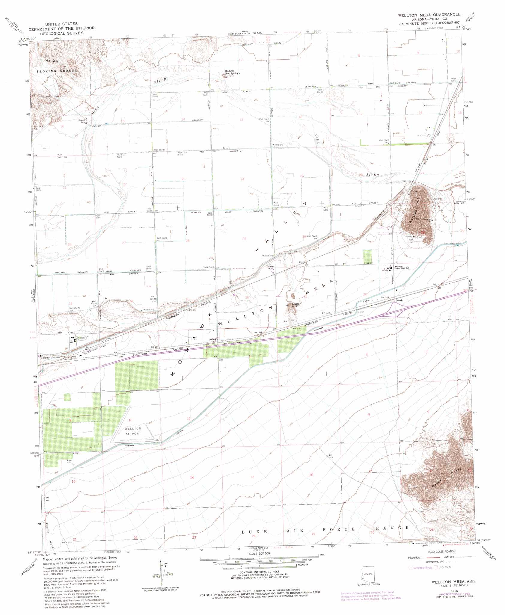
Wellton Mesa Topo Map Arizona
To zoom in, hover over the map of Wellton Mesa
USGS Topo Quad 32114f1 - 1:24,000 scale
| Topo Map Name: | Wellton Mesa |
| USGS Topo Quad ID: | 32114f1 |
| Print Size: | ca. 21 1/4" wide x 27" high |
| Southeast Coordinates: | 32.625° N latitude / 114° W longitude |
| Map Center Coordinates: | 32.6875° N latitude / 114.0625° W longitude |
| U.S. State: | AZ |
| Filename: | o32114f1.jpg |
| Download Map JPG Image: | Wellton Mesa topo map 1:24,000 scale |
| Map Type: | Topographic |
| Topo Series: | 7.5´ |
| Map Scale: | 1:24,000 |
| Source of Map Images: | United States Geological Survey (USGS) |
| Alternate Map Versions: |
Wellton Mesa AZ 1965, updated 1966 Download PDF Buy paper map Wellton Mesa AZ 1965, updated 1978 Download PDF Buy paper map Wellton Mesa AZ 1965, updated 1982 Download PDF Buy paper map Wellton Mesa AZ 1965, updated 1982 Download PDF Buy paper map Wellton Mesa AZ 2011 Download PDF Buy paper map Wellton Mesa AZ 2014 Download PDF Buy paper map |
1:24,000 Topo Quads surrounding Wellton Mesa
Middle Mountains South |
Red Bluff Mountain Nw |
Salton Tanks |
North Of Roll |
Mesquite Jim Well |
Dome |
Red Bluff Mountain West |
Red Bluff Mountain East |
Roll |
Growler |
Ligurta |
Wellton |
Wellton Mesa |
Tacna |
Mohawk |
Fortuna Mine |
Wellton Hills |
Wellton Se |
Mohawk Sw |
Mohawk Se |
Vopoki Ridge |
Cipriano Pass |
Raven Butte |
Buck Peak |
East Of Buck Peak |
> Back to 32114e1 at 1:100,000 scale
> Back to 32114a1 at 1:250,000 scale
> Back to U.S. Topo Maps home
Wellton Mesa topo map: Gazetteer
Wellton Mesa: Airports
Antelope Ranch Airport elevation 76m 249′Wellton Airport elevation 99m 324′
Wellton Mesa: Canals
Mohawk 6.3 Lateral elevation 95m 311′Mohawk 6.9 Lateral elevation 97m 318′
Mohawk 7.9 Lateral elevation 98m 321′
Mohawk 8.5 Lateral elevation 101m 331′
Mohawk 9.1 Lateral elevation 100m 328′
Mohawk 9.8 Lateral elevation 113m 370′
Wellton Canal elevation 80m 262′
Wellton Lateral 7.7 elevation 71m 232′
Wellton Mesa: Crossings
Wellton Overpass elevation 91m 298′Wellton Mesa: Mines
Gypsum Mine elevation 122m 400′Wellton Mesa: Populated Places
Asher elevation 93m 305′Noah elevation 101m 331′
Wellton Mesa: Summits
Antelope Hill elevation 245m 803′Radar Hill elevation 137m 449′
Wellton Mesa elevation 102m 334′
Wellton Mesa digital topo map on disk
Buy this Wellton Mesa topo map showing relief, roads, GPS coordinates and other geographical features, as a high-resolution digital map file on DVD: