Calexico Topo Map California
To zoom in, hover over the map of Calexico
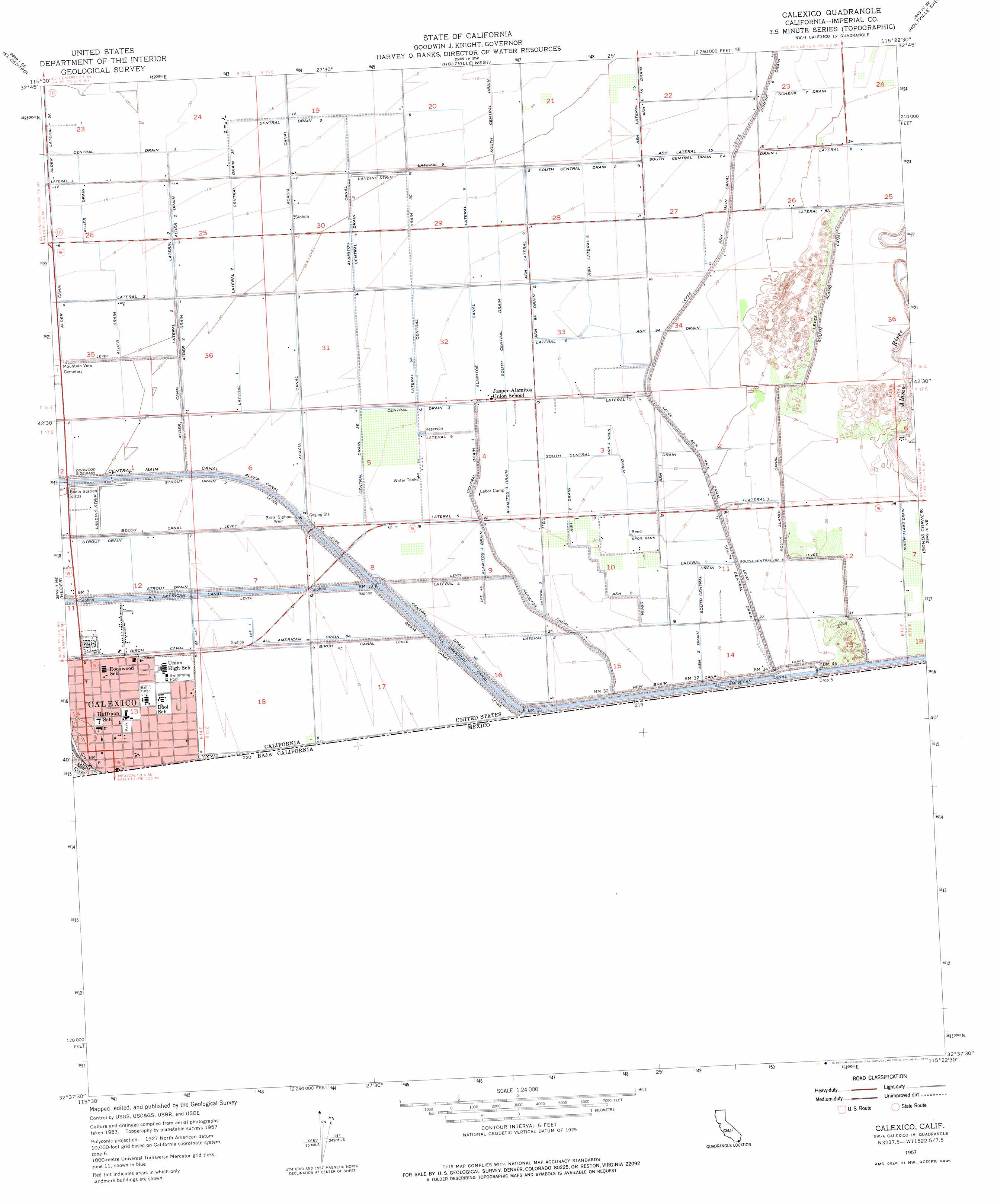
USGS Topo Quad 32115f4 - 1:24,000 scale
| Topo Map Name: | Calexico |
| USGS Topo Quad ID: | 32115f4 |
| Print Size: | ca. 21 1/4" wide x 27" high |
| Southeast Coordinates: | 32.625° N latitude / 115.375° W longitude |
| Map Center Coordinates: | 32.6875° N latitude / 115.4375° W longitude |
| U.S. State: | CA |
| Filename: | o32115f4.jpg |
| Download Map JPG Image: | Calexico topo map 1:24,000 scale |
| Map Type: | Topographic |
| Topo Series: | 7.5´ |
| Map Scale: | 1:24,000 |
| Source of Map Images: | United States Geological Survey (USGS) |
| Alternate Map Versions: |
Calexico CA 1957, updated 1958 Download PDF Buy paper map Calexico CA 1957, updated 1976 Download PDF Buy paper map Calexico CA 1957, updated 1976 Download PDF Buy paper map Calexico CA 1976, updated 1980 Download PDF Buy paper map Calexico CA 2012 Download PDF Buy paper map Calexico CA 2015 Download PDF Buy paper map |
1:24,000 Topo Quads surrounding Calexico
Brawley Nw |
Brawley |
Alamorio |
Holtville Ne |
Glamis Nw |
Seeley |
El Centro |
Holtville West |
Holtville East |
Glamis Sw |
Mount Signal |
Heber |
Calexico |
Bonds Corner |
Midway Well Nw |
> Back to 32115e1 at 1:100,000 scale
> Back to 32114a1 at 1:250,000 scale
> Back to U.S. Topo Maps home
Calexico topo map: Gazetteer
Calexico: Canals
Alamitos Canal elevation 1m 3′Alamitos Canal Lateral Eight elevation 4m 13′
Alamitos Three Drain elevation 6m 19′
Alder Canal Lateral Two elevation 1m 3′
Alder Drain elevation -3m -10′
Alder Two Drain elevation 0m 0′
All American Drain Eight A elevation 4m 13′
Ash Four Drain elevation 6m 19′
Ash Lateral Nine elevation 4m 13′
Ash Lateral Six elevation 5m 16′
Ash Nine A Drain elevation 7m 22′
Ash Three Drain elevation 7m 22′
Ash Two Drain elevation 6m 19′
Brair Canal elevation 5m 16′
Brair Siphon Weir elevation 4m 13′
Central Drain Three elevation -4m -14′
Central Drain Three elevation 1m 3′
Central Drain Three C elevation 1m 3′
Central Drain Three E elevation 5m 16′
Central Drain Three E elevation 4m 13′
Central Drain Three F elevation -2m -7′
Drain One elevation 5m 16′
Eight A Lateral elevation 2m 6′
Lateral Eight elevation 5m 16′
Lateral Five elevation 7m 22′
Lateral Five elevation 5m 16′
Lateral Five A elevation 10m 32′
Lateral Four elevation -4m -14′
Lateral Four elevation 5m 16′
Lateral Four A elevation 6m 19′
Lateral Nine elevation 0m 0′
Lateral One elevation 3m 9′
Lateral One elevation 2m 6′
Lateral Six elevation 4m 13′
Lateral Six elevation 10m 32′
Lateral Six A elevation 3m 9′
Lateral Three elevation -1m -4′
Lateral Three elevation 9m 29′
Lateral Three elevation 7m 22′
Lateral Two elevation 7m 22′
Lateral Two elevation 7m 22′
Lateral Two elevation 0m 0′
New Brair Canal elevation 7m 22′
Schenk Seven Drain elevation 5m 16′
Schenk Six Drain elevation 4m 13′
South Alamo Drain elevation 9m 29′
South Central Drain elevation 1m 3′
South Central Drain Five elevation 7m 22′
South Central Drain Six elevation 9m 29′
South Central Drain Two elevation 2m 6′
South Central Drain Two-A elevation 4m 13′
Stout Drain Two elevation 2m 6′
Calexico: Parks
Border Park elevation 1m 3′Cortez Park elevation 4m 13′
Crummett Park elevation 2m 6′
Emerson Park elevation 1m 3′
Heber Dunes State Vehicular Recreation Area elevation 10m 32′
Kennedy Gardens Park elevation 1m 3′
Rockwood Plaza elevation 1m 3′
Calexico: Populated Places
Calexico elevation 1m 3′Calexico: Post Offices
Calexico Post Office elevation 1m 3′Calexico digital topo map on disk
Buy this Calexico topo map showing relief, roads, GPS coordinates and other geographical features, as a high-resolution digital map file on DVD: