El Centro Topo Map California
To zoom in, hover over the map of El Centro
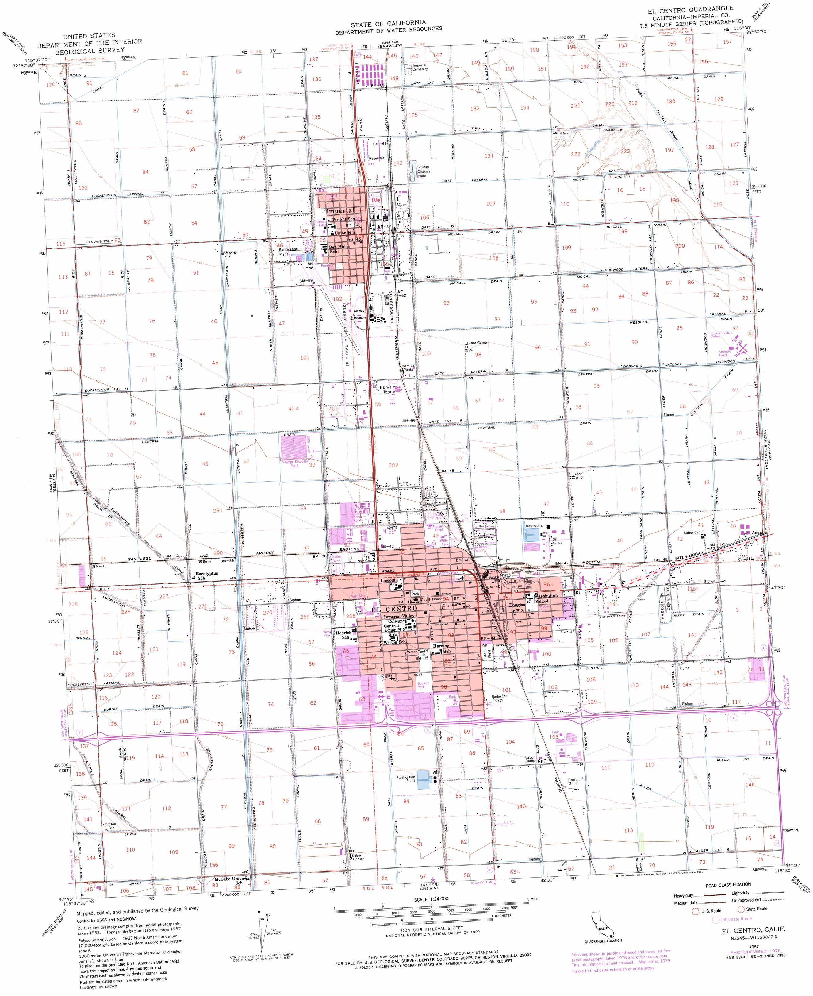
USGS Topo Quad 32115g5 - 1:24,000 scale
| Topo Map Name: | El Centro |
| USGS Topo Quad ID: | 32115g5 |
| Print Size: | ca. 21 1/4" wide x 27" high |
| Southeast Coordinates: | 32.75° N latitude / 115.5° W longitude |
| Map Center Coordinates: | 32.8125° N latitude / 115.5625° W longitude |
| U.S. State: | CA |
| Filename: | o32115g5.jpg |
| Download Map JPG Image: | El Centro topo map 1:24,000 scale |
| Map Type: | Topographic |
| Topo Series: | 7.5´ |
| Map Scale: | 1:24,000 |
| Source of Map Images: | United States Geological Survey (USGS) |
| Alternate Map Versions: |
El Centro CA 1957, updated 1958 Download PDF Buy paper map El Centro CA 1957, updated 1958 Download PDF Buy paper map El Centro CA 1957, updated 1973 Download PDF Buy paper map El Centro CA 1957, updated 1980 Download PDF Buy paper map El Centro CA 1957, updated 1980 Download PDF Buy paper map El Centro CA 1976, updated 1980 Download PDF Buy paper map El Centro CA 2012 Download PDF Buy paper map El Centro CA 2015 Download PDF Buy paper map |
1:24,000 Topo Quads surrounding El Centro
Kane Spring |
Westmorland West |
Westmorland East |
Wiest |
Amos |
Superstition Mountain |
Brawley Nw |
Brawley |
Alamorio |
Holtville Ne |
Plaster City |
Seeley |
El Centro |
Holtville West |
Holtville East |
Yuha Basin |
Mount Signal |
Heber |
Calexico |
Bonds Corner |
> Back to 32115e1 at 1:100,000 scale
> Back to 32114a1 at 1:250,000 scale
> Back to U.S. Topo Maps home
El Centro topo map: Gazetteer
El Centro: Airports
Douthitt Strip elevation -13m -43′Imperial County Airport elevation -16m -53′
El Centro: Areas
Stark Field elevation -12m -40′El Centro: Canals
Acatia Drain Six A elevation -13m -43′Acatia Lateral Eleven elevation -17m -56′
Alder Canal elevation -8m -27′
Alder Drain Eleven elevation -12m -40′
Alder Lateral Eleven elevation -11m -37′
Alder Lateral Seven elevation -13m -43′
Alder Lateral Six elevation -6m -20′
Central Drain Four elevation -16m -53′
Central Drain Seven elevation -17m -56′
Central Drain Six elevation -15m -50′
Central Drain Ten elevation -9m -30′
Central Drain Three elevation -10m -33′
Central Drain Three elevation -15m -50′
Central Drain Three A elevation -9m -30′
Central Drain Three H elevation -12m -40′
Central Main Canal elevation -17m -56′
Dahlia Canal elevation -9m -30′
Dahlia Drain elevation -19m -63′
Dahlia Lateral elevation -8m -27′
Dahlia Lateral Eight elevation -20m -66′
Dandelion Canal elevation -16m -53′
Date Canal elevation -8m -27′
Date Drain elevation -10m -33′
Date Drain Three-B elevation -8m -27′
Date Lateral Eight elevation -19m -63′
Date Lateral Five elevation -16m -53′
Date Lateral Nine elevation -20m -66′
Date Lateral Seven elevation -18m -60′
Date Lateral Seven-A elevation -19m -63′
Date Lateral Six elevation -17m -56′
Date Lateral Ten elevation -20m -66′
Dogwood Canal elevation -11m -37′
Dogwood Canal elevation -17m -56′
Dogwood Lateral Eight elevation -18m -60′
Dogwood Lateral Six elevation -19m -63′
Dogwood Lateral Ten elevation -19m -63′
Dogwood Lateral Ten A elevation -20m -66′
Dolson Drain Four elevation -23m -76′
Dubois Drain elevation -9m -30′
Dubois Drain One elevation -8m -27′
Ebony Canal elevation -15m -50′
Elder Lateral Two elevation -7m -23′
Eucalyptus Canal elevation -11m -37′
Eucalyptus Lateral 10 elevation -16m -53′
Eucalyptus Lateral Eleven elevation -14m -46′
Eucalyptus Lateral Five elevation -9m -30′
Eucalyptus Lateral Four elevation -10m -33′
Eucalyptus Lateral Seventeen elevation -17m -56′
Eucalyptus Lateral Two elevation -8m -27′
Evergreen Canal elevation -8m -27′
Evergreen Lateral Three elevation -12m -40′
Heber Drain elevation -10m -33′
McCall Drain Five elevation -21m -69′
McCall Drain Five A elevation -19m -63′
McCall Drain Five B elevation -19m -63′
McCall Drain Four elevation -31m -102′
McCall Drain One elevation -35m -115′
McCall Drain One B elevation -25m -83′
Newside Canal elevation -17m -56′
Newside Drain elevation -19m -63′
North Central Drain One elevation -17m -56′
North Central Drain Two elevation -17m -56′
Rice Drain elevation -17m -56′
Rice Drain One elevation -16m -53′
Rose Canal elevation -32m -105′
Rose Drain Two A elevation -27m -89′
Rose Lateral Three elevation -33m -109′
Rose Lateral Two elevation -32m -105′
Wildcat Drain elevation -7m -23′
El Centro: Dams
El Centro Wpp 2016 Dam elevation -14m -46′El Centro: Parks
Adams Park elevation -13m -43′Bucklin Park elevation -10m -33′
California Mid-Winter Fairgrounds elevation -17m -56′
City Park elevation -18m -60′
Desert Gardens Park elevation -10m -33′
Emerson Park elevation -17m -56′
Evans Park elevation -18m -60′
Fraizer Field elevation -14m -46′
Irving Park elevation -19m -63′
McGee Park elevation -13m -43′
North Park elevation -13m -43′
Swarthout Field elevation -14m -46′
West Main Park elevation -12m -40′
West Park elevation -10m -33′
El Centro: Populated Places
El Centro elevation -12m -40′Imperial elevation -18m -60′
Wilsie elevation -10m -33′
El Centro: Post Offices
El Centro Main Post Office elevation -13m -43′Imperial Post Office elevation -18m -60′
El Centro digital topo map on disk
Buy this El Centro topo map showing relief, roads, GPS coordinates and other geographical features, as a high-resolution digital map file on DVD: