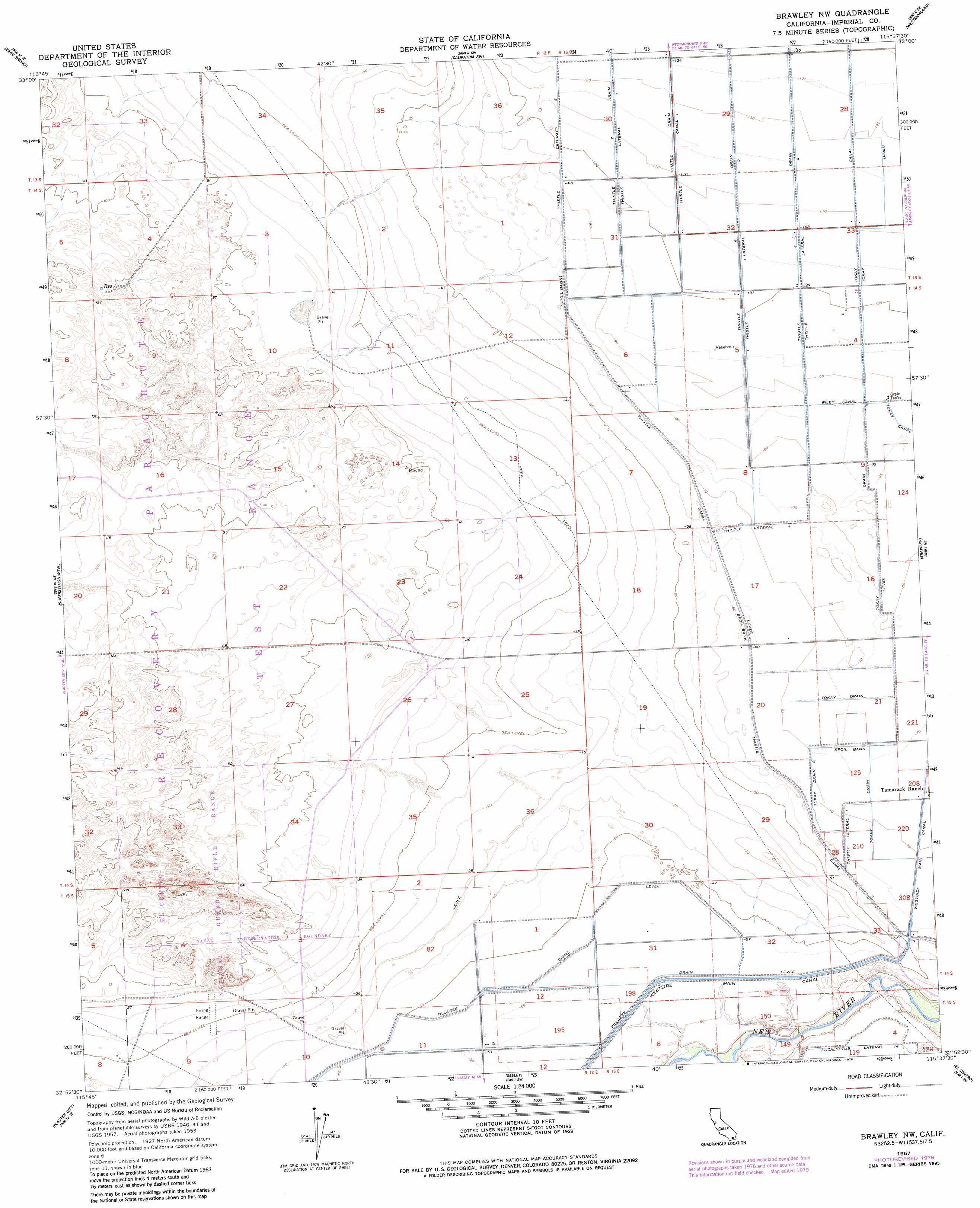
Brawley Nw Topo Map California
To zoom in, hover over the map of Brawley Nw
USGS Topo Quad 32115h6 - 1:24,000 scale
| Topo Map Name: | Brawley Nw |
| USGS Topo Quad ID: | 32115h6 |
| Print Size: | ca. 21 1/4" wide x 27" high |
| Southeast Coordinates: | 32.875° N latitude / 115.625° W longitude |
| Map Center Coordinates: | 32.9375° N latitude / 115.6875° W longitude |
| U.S. State: | CA |
| Filename: | o32115h6.jpg |
| Download Map JPG Image: | Brawley Nw topo map 1:24,000 scale |
| Map Type: | Topographic |
| Topo Series: | 7.5´ |
| Map Scale: | 1:24,000 |
| Source of Map Images: | United States Geological Survey (USGS) |
| Alternate Map Versions: |
Brawley NW CA 1957, updated 1958 Download PDF Buy paper map Brawley NW CA 1957, updated 1979 Download PDF Buy paper map Brawley NW CA 1957, updated 1979 Download PDF Buy paper map Brawley NW CA 2012 Download PDF Buy paper map Brawley NW CA 2015 Download PDF Buy paper map |
1:24,000 Topo Quads surrounding Brawley Nw
Kane Spring Nw |
Kane Spring Ne |
Obsidian Butte |
Niland |
Iris |
Harpers Well |
Kane Spring |
Westmorland West |
Westmorland East |
Wiest |
Plaster City Nw |
Superstition Mountain |
Brawley Nw |
Brawley |
Alamorio |
Painted Gorge |
Plaster City |
Seeley |
El Centro |
Holtville West |
Coyote Wells |
Yuha Basin |
Mount Signal |
Heber |
Calexico |
> Back to 32115e1 at 1:100,000 scale
> Back to 32114a1 at 1:250,000 scale
> Back to U.S. Topo Maps home
Brawley Nw topo map: Gazetteer
Brawley Nw: Canals
Fillaree Canal elevation -15m -50′Riley Canal elevation -25m -83′
Thistle Canal elevation -33m -109′
Thistle Drain elevation -33m -109′
Thistle Five Drain elevation -32m -105′
Thistle Four Drain elevation -32m -105′
Thistle Lateral Eight elevation -27m -89′
Thistle Lateral Five elevation -30m -99′
Thistle Lateral Four elevation -30m -99′
Thistle Lateral One elevation -18m -60′
Thistle Lateral Seven elevation -33m -109′
Thistle Seven Drain elevation -30m -99′
Tokay Canal elevation -32m -105′
Tokay Drain elevation -32m -105′
Tokay Drain One elevation -22m -73′
Tokay Drain Two elevation -19m -63′
Brawley Nw digital topo map on disk
Buy this Brawley Nw topo map showing relief, roads, GPS coordinates and other geographical features, as a high-resolution digital map file on DVD: