In-Ko-Pah Gorge Topo Map California
To zoom in, hover over the map of In-Ko-Pah Gorge
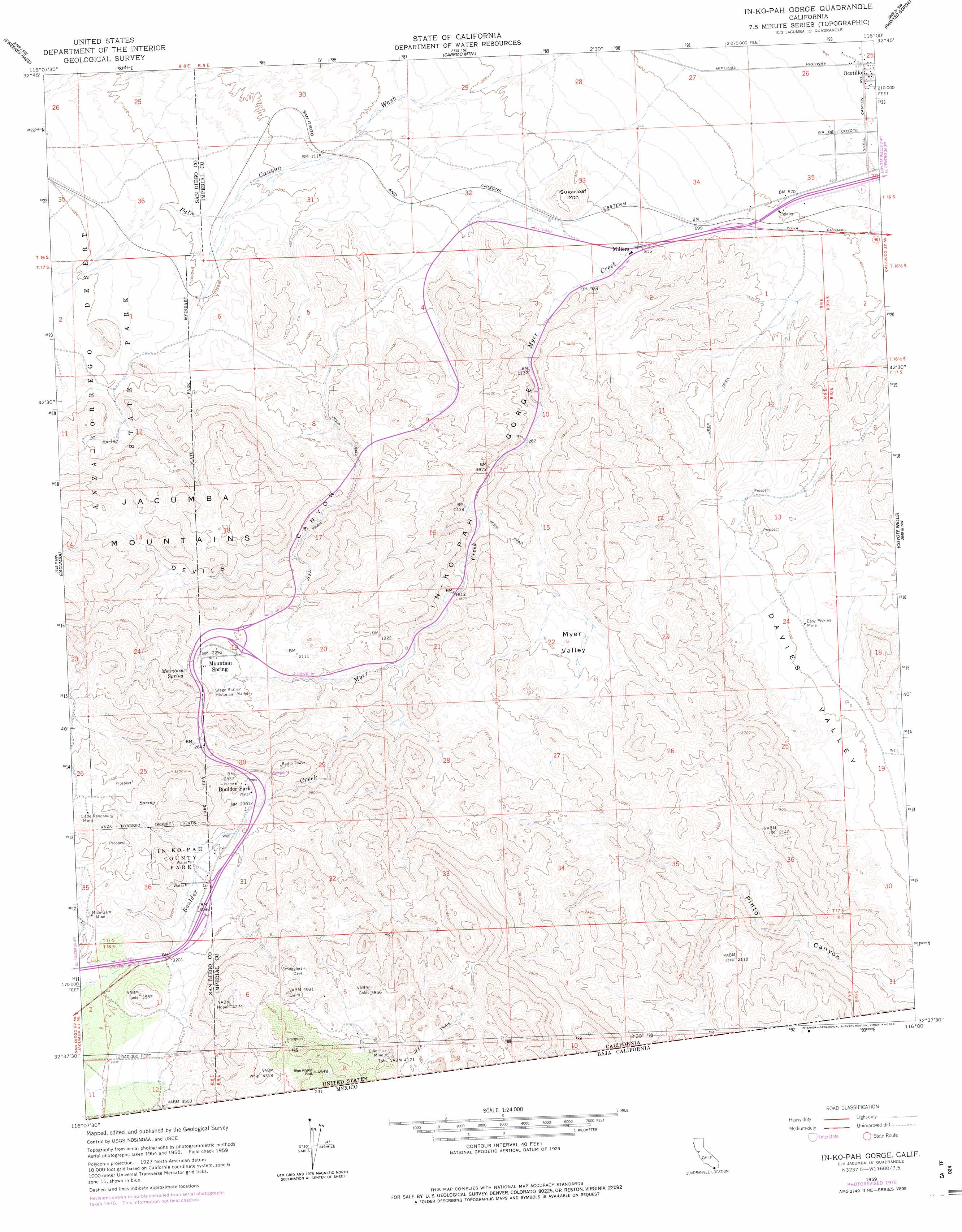
USGS Topo Quad 32116f1 - 1:24,000 scale
| Topo Map Name: | In-Ko-Pah Gorge |
| USGS Topo Quad ID: | 32116f1 |
| Print Size: | ca. 21 1/4" wide x 27" high |
| Southeast Coordinates: | 32.625° N latitude / 116° W longitude |
| Map Center Coordinates: | 32.6875° N latitude / 116.0625° W longitude |
| U.S. State: | CA |
| Filename: | o32116f1.jpg |
| Download Map JPG Image: | In-Ko-Pah Gorge topo map 1:24,000 scale |
| Map Type: | Topographic |
| Topo Series: | 7.5´ |
| Map Scale: | 1:24,000 |
| Source of Map Images: | United States Geological Survey (USGS) |
| Alternate Map Versions: |
In-ko-pah Gorge CA 1959, updated 1961 Download PDF Buy paper map In-ko-pah Gorge CA 1959, updated 1969 Download PDF Buy paper map In-ko-pah Gorge CA 1959, updated 1978 Download PDF Buy paper map In-ko-pah Gorge CA 1997, updated 2003 Download PDF Buy paper map In-Ko-Pah Gorge CA 2012 Download PDF Buy paper map In-Ko-Pah Gorge CA 2015 Download PDF Buy paper map |
1:24,000 Topo Quads surrounding In-Ko-Pah Gorge
Agua Caliente Springs |
Arroyo Tapiado |
Carrizo Mountain Ne |
Plaster City Nw |
Superstition Mountain |
Sombrero Peak |
Sweeney Pass |
Carrizo Mountain |
Painted Gorge |
Plaster City |
Live Oak Springs |
Jacumba |
In-Ko-Pah Gorge |
Coyote Wells |
Yuha Basin |
Tierra Del Sol |
||||
> Back to 32116e1 at 1:100,000 scale
> Back to 32116a1 at 1:250,000 scale
> Back to U.S. Topo Maps home
In-Ko-Pah Gorge topo map: Gazetteer
In-Ko-Pah Gorge: Mines
Easy Pickins Mine elevation 355m 1164′Little Randsburg Mine elevation 1059m 3474′
Mica Gem Mine elevation 1006m 3300′
In-Ko-Pah Gorge: Parks
In-Ko-Pah County Park elevation 956m 3136′Mountain Springs County Park elevation 742m 2434′
Stage Station Historical Marker elevation 735m 2411′
In-Ko-Pah Gorge: Populated Places
Boulder Park elevation 891m 2923′In-Ko-Pah Gorge: Springs
Mountain Spring elevation 706m 2316′In-Ko-Pah Gorge: Streams
Boulder Creek elevation 538m 1765′Myer Creek elevation 136m 446′
In-Ko-Pah Gorge: Summits
Sugarloaf Mountain elevation 298m 977′In-Ko-Pah Gorge: Valleys
Davies Valley elevation 361m 1184′Devils Canyon elevation 340m 1115′
In-Ko-Pah Gorge elevation 259m 849′
Myer Valley elevation 464m 1522′
In-Ko-Pah Gorge digital topo map on disk
Buy this In-Ko-Pah Gorge topo map showing relief, roads, GPS coordinates and other geographical features, as a high-resolution digital map file on DVD: